
by Abby Seadler Tuesday, April 3, 2012
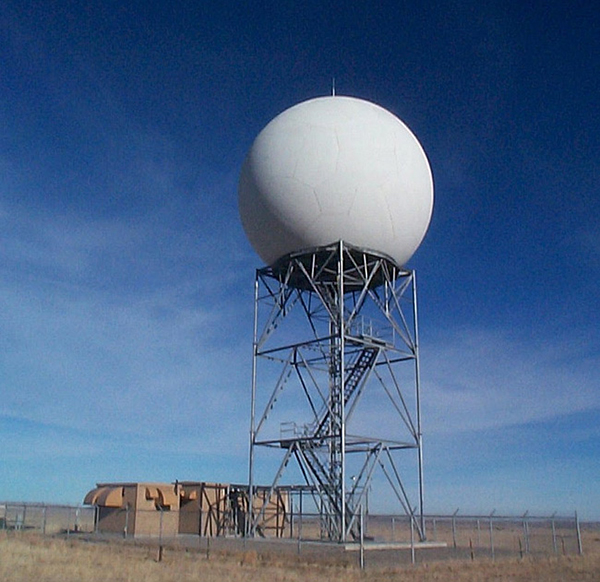
Image of Doppler radar. There are currently 155 WSR-88D Doppler radar in the U.S. including Guam and Puerto Rico. NOAA
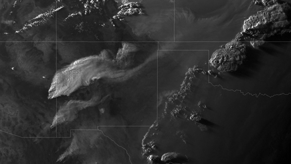
Satellite imagery of massive wildfire smoke plumes over Arizona, New Mexico, Colorado, Texas and Oklahoma. NOAA
Abby Seadler is the member society services manager for the American Geosciences Institute and contributing science policy writer for EARTH. Abby Seadler
It doesn’t take a geoscientist to know that severe weather impacts our lives. Tornadoes, hurricanes, windstorms, solar storms, droughts … the list goes on. Last year shattered records — hundreds dead in the Southern tornadoes, three of the largest forest fires in state histories, and at least 15 dead in Oklahoma City alone due to record high temperatures. This year is off to a roaring start as well. Although folks up in Michigan may have enjoyed June temperatures in early March, the people in Tornado Alley certainly didn’t need an early start to their spring — experiencing 57 tornadoes ahead of schedule in February. No, it doesn’t take a geoscientist to know that these severe weather events have equally as severe consequences. But it does take a geoscientist to tell Congress exactly what we should do to predict these threats.
NOAA monitors and predicts the weather for the United States, and also gathers global weather and climate data essential for protecting not only lives, but also livelihoods. The House Science, Space and Technology committee convened a hearing on March 28 to better understand how NOAA procures its weather data, and how current budget restrictions could impact its ability to effectively predict severe weather. Policymakers wanted to know which instruments best help NOAA predict severe weather and if the government could save money by contracting private companies to do these tasks instead of NOAA. The answer, of course, is complicated.
First, NOAA has a number of weapons in its data-gathering arsenal to forecast severe weather. It employs in situ devices such as Doppler radar for mesoscale predictions on Earth’s surface, and satellites that help us see the bigger picture. Radar technologies are primarily used for warning systems and can provide important real-time data on storm structure that increase lead times and decrease false alarm rates. NOAA then uses two kinds of satellites, geostationary (the kind that hover over one spot more than 35,00 kilometers above Earth’s surface), and polar orbiting (the kind that make nearly polar orbits roughly 14 times per day) satellites. According to NOAA, geostationary satellites provide continuous monitoring of atmospheric “triggers” for severe weather, and also help monitor storm development and track their movements. Polar orbiting satellites, among many other things, help predict weather forecasts two to ten days in advance.
All of these instruments and data-gathering techniques complement each other. Information gathered from satellites accounts for 94 percent of the data we use in weather models that predict and track storms. Doppler radar allows scientists unprecedented precision in monitoring existing storms. For example, Doppler radar offers scientists the ability to detect rotation within a thunderstorm, which is often a precursor to the development of tornadoes. Satellites do not offer that capability. Therefore, the tortuous question to answer is: Would you rather spend money to ensure that we can see a storm coming days in advance and to create a more comprehensive picture of our global weather and climate patterns, or spend money to examine storms with more precision in order to accurately predict the path and magnitude of storms that are already formed or forming?
Second, NOAA already has contracts with private companies to facilitate some of its data gathering, and is currently purchasing some of its atmospheric data from commercial satellites. Representatives from three companies testified at the hearing: AirDat LLC touted its TAMDAR (Tropospheric Airborne Meteorological Data Reporting) systems, ITT Exelis explained its involvement in creating cutting-edge satellites with NOAA, and GeoMetWatch noted how it helps NOAA operate geostationary hyperspectral imaging and sounding systems. NOAA could rely more heavily on these commercial operators to facilitate and gather more of its data in the future.
Two bills were introduced last year to help mitigate severe weather: The Hurricane and Tornado Mitigation Investment Act of 2011 (H.R. 2067), and the National Hurricane Research Initiative Act of 2011 (S. 692). The first act was referred to the House Committee on Ways and Means back in June, and the second was sent to the Senate Committee on Commerce, Science and Transportation last May.
It is crucial that the United States continue to fund research for severe weather monitoring and mitigation. Though there is definitely a role for private companies in these endeavors (and probably a growing role in the future), there are certain R&D functions that only a government organization such as NOAA can fill.
© 2008-2021. All rights reserved. Any copying, redistribution or retransmission of any of the contents of this service without the expressed written permission of the American Geosciences Institute is expressly prohibited. Click here for all copyright requests.