
by Nick Luchetti Friday, June 21, 2013
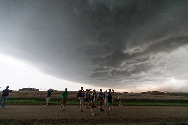
Virginia Tech students witness a supercell in person near Hays, Kan. Trevor White
In this series of three posts, Nick Luchetti, an undergraduate meteorology student at Virginia Tech, describes the thrills and emotions he experienced while chasing supercell storms and tornadoes in the Great Plains this past spring.
This past May, I had the incredible opportunity to fulfill a personal dream of chasing tornadic storms across the Great Plains. As a meteorology student at Virginia Tech, I had been waiting several years for this journey. The meteorology program at Virginia Tech offers a Great Plains field course intended to improve students' real-time forecasting and navigation skills in unfamiliar environments.
Over five days of chasing, we successfully intercepted several supercell thunderstorms, which included rotating updrafts and wall clouds, incredible shelf clouds and associated gust fronts, intense lightning strikes and grapefruit-sized hail. Storms such as these as are nearly impossible to describe in words; you really do have to experience them with your own eyes to grasp their sheer intensity and the fear they can create.
Studying the genesis of a tornado is the last frontier of meteorology. Unfortunately (from a scientific point of view), although we positioned ourselves perfectly on several rotating supercells, we did not once see a tornado stretch to the ground. (Some of the storms we filmed did indeed produce tornadoes, but not in our vicinity. And we were about two hours south of the storm cell that eventually produced the Moore, Okla., tornado on May 20.) Despite the portrayals of tornado chasing on reality TV shows, it is actually incredibly difficult to witness a tornado. Tornadoes simply occur too infrequently to be easily observed (as well as for the needed research to be conducted). Through this series of posts, I hope to provide an insider’s look at the realities of chasing storms.
Getting to the Great Plains
If you are not passionate about storms, this sort of trip is not for you. Ninety-five percent of chasing is driving, with the goal being to position yourself to intercept a storm. Over a nine-day stretch, our team traveled more than 8,000 kilometers through 11 states while spending more than 90 hours inside a van. Granted, we traveled from Blacksburg, Va., just to get to where we were going, which accounted for several days and several thousand kilometers, but even local Great Plains chasers sometimes have to travel long distances through multiple states just to position themselves for potential storms. Even on a chase day, you might travel for hours to catch storms firing off in another state.
Chase Day
Chase mode feels like a blur. You lose any sense of the time of day, or even what day it is, what county you are in or the name of the last town through which you passed. You start thinking about days of the week in terms of severe weather outlooks (Day 1 outlook, Day 2 outlook, Day 3 outlook, etc.) It truly is a wild feeling.
Three key atmospheric ingredients are needed for severe thunderstorms: instability, represented by the Convective Available Potential Energy (CAPE), moisture (i.e., high dew points), and a source of lift such as a front, dry line or vorticity wave. After locating an area with these three ingredients, smaller scales are studied to look for tornadic ingredients. For long-lived supercells capable of producing a tornado, one of the key ingredients is wind shear. We look for areas with strong upper- and lower-level wind shear, and observe curvature in the wind field with height, which is crucial for rotating storms. We also look for areas of high low-level moisture and low-level cloud bases using tools such as Theta E values and Lifting Condensation Levels. The lower the cloud base and the more moisture near Earth’s surface, the more likely a funnel cloud is to stretch to the surface.
Once an area with a high tornado potential is targeted, the drive begins. To decipher the best position for a storm intercept, forecasters use up-to-the-minute meteorological model outputs, reading local weather offices’ Hazardous Weather Outlooks (HWO) and Area Forecast Discussions (AFD) while choosing navigation routes. And when picking a final destination, another important consideration is the terrain. Some areas are not well-suited for chasing tornadoes. For instance, it’s best to stay away from areas that lack interconnected networks of roads, which allow for easy entrances to and exits from storm zones. Areas with abundant tree cover are also avoided because the trees obstruct our view of storms and of funnel clouds that may potentially stretch to the ground as tornadoes. Additionally, metropolitan cities are avoided for multiple reasons. First, trying to outrun storms in highly congested areas is extremely dangerous. And second, our chase team adds three more vehicles to the mass of people who may be trying to flee the storm. (This no-city rule is not followed by all chase teams, but it is a strict rule observed by the Hokie Storm Chasers.)
Once positioned where we think storm initiation will occur, we wait. We monitor visible satellite imagery to detect where cumulus clouds bubble up. Once cumulus clouds initiate, the chase team then waits for cells to show up on the base reflectivity radar. As a cell appears on the radar, the forecast models are dismissed; our singular focus at this point is to position ourselves around the most discrete storm cell.
The chase is on …
© 2008-2021. All rights reserved. Any copying, redistribution or retransmission of any of the contents of this service without the expressed written permission of the American Geosciences Institute is expressly prohibited. Click here for all copyright requests.