
by Timothy Oleson Tuesday, October 16, 2012
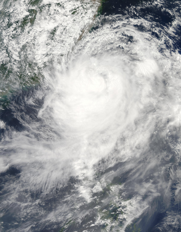
Typhoon Morakot passes over Taiwan on Aug. 7, 2009. It was followed by two large earthquakes, one later in 2009 and one in 2010. NASA image by Jeff Schmaltz, MODIS Rapid Response Team, Goddard Space Flight Center
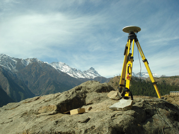
Researchers have correlated the timing of slight ground motions in the Himalayas using GPS measurements, including from this GPS station near Simikot in northwestern Nepal, to cyclic variations in seismicity beneath the mountains and the annual monsoon. Thomas Ader
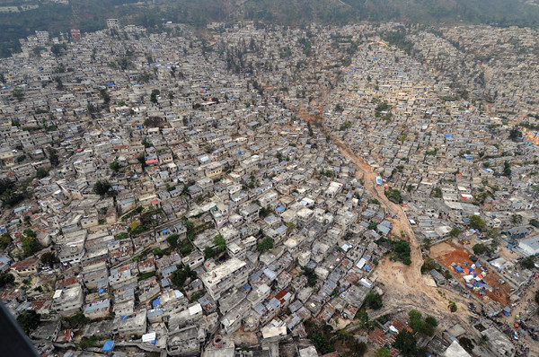
An aerial view of Haiti's capital, Port-au-Prince, about two months after a magnitude-7 earthquake struck nearby. A landslide is evident among crowded hillside houses and buildings. U.S. Navy photo by Senior Chief Mass Communication Specialist Spike Call
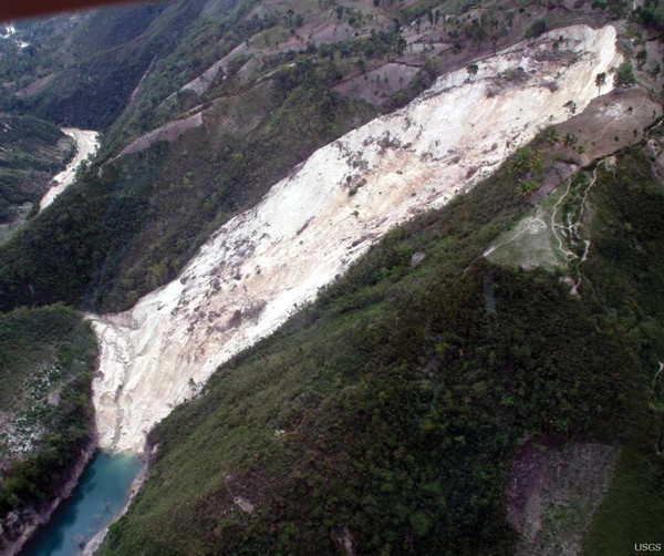
A landslide near Haiti's southern coast erodes tremendous amounts of sediment from the mountains, a process that can change the stress loads on faults. U.S. Geological Survey
The U.S. Geological Survey’s website states it in no uncertain terms: “There is no such thing as ’earthquake weather.'”
Not too surprising, right? After all, how could the seemingly insignificant stresses imposed on the planet’s surface by mere weather instigate seismic shaking far underfoot? (Meteorologists measure atmospheric pressures in kilopascals; geophysicists measure tectonic pressures in mega- and gigapascals.) Earthquakes and heavy rainstorms do occasionally produce comparable results on the planet’s surface, devastating landscapes and impacting humans, but it’s hard to imagine any more of a connection between such disparate phenomena. The physical processes involved operate in different realms — below- versus above-ground — and predominantly on very different timescales: Stress builds on faults over the course of years, in some cases hundreds to thousands of years, whereas storm systems persist only for days or, in the case of seasonal monsoons, a few months.
Yet, from at least the time of Aristotle, some people have professed links between atmospheric conditions and seismic shaking. And as the ability to record Earth’s rumblings has continued to improve, efforts to demonstrate such links scientifically have persisted into the present century.
Last December, the annual meeting of the American Geophysical Union in San Francisco, Calif., featured a session inspired, at least in part, by the topic. Two presentations during a session entitled “Climate Loads as Forcers of Seismic and Volcanic Processes” suggested that heavy rains were possibly to blame for observed patterns of seismicity in different parts of the world. The session caught the attention of other scientists and the media alike.
The first presentation described an apparent negative correlation between annual variations in seismicity beneath the Himalayan Mountains and the South Asian monsoon, which dumps roughly 80 percent of India’s annual precipitation on the subcontinent between June and September. Whereas this study looked at a catalog of mostly small- to moderate-sized events, the second study, more provocatively, suggested links between especially wet tropical storms and subsequent large earthquakes. Among those cited were the devastating 2010 Haiti earthquake and a series of damaging temblors in Taiwan over the last half century, which were preceded by large storms.
The ensuing media headlines, including “Heavy Rainfall Can Cause Earthquakes” and “Severe Weather Triggers Earthquakes,” were cringe-worthy proclamations for many scientists who are wary of anything implying that earthquakes may be predictable. Not surprisingly, the projects have encountered varying levels of skepticism from other seismologists and geophysicists over whether the observed seismicity patterns can really be linked to heavy rains.
Even the researchers behind the work are quick to point out that their results mean little for earthquake prediction and that they are talking about triggers, rather than causes, that affect the timing of earthquakes bound to happen eventually due to ever-accumulating tectonic stress. (This is a distinction akin to saying that whereas a good whack from a wrecking ball might trigger the collapse of an aging building, the cause would be structural weaknesses and, ultimately, gravity).
Nonetheless, the new research offers insights and opportunities to better understand the complex interplay of forces that control earthquakes, they suggest, which can only help seismic hazard mitigation and preparation in the future. And along with other recent efforts to illuminate the subsurface effects of surficial processes, these studies are a far cry from former explanations of earthquake weather.
“The old notion of earthquake weather … was very prevalent — the idea that earthquakes and weather were related somehow,” says Susan Hough, a seismologist at the U.S. Geological Survey in Pasadena, Calif., who has written extensively about the history of earthquake prediction. The ancient Greeks are usually credited with espousing the first relation between weather and seismicity. In the fourth century B.C., Aristotle is said to have surmised that trapped subterranean winds caused earthquakes when they shifted about or, in the case of large earthquakes, broke through the ground to escape into the atmosphere.
In more recent times, people have thought, for example, that earthquakes are more likely when it is hot and dry due to the seemingly frequent co-occurrence of such conditions, particularly in California, Hough says. But, she notes, “it’s usually hot and dry” in California and if you look at the numbers, you see proportionally more quakes on hot and dry days versus on cool and wet days, just as expected. There have also been studies “here and there that make an association between typhoons and/or hurricanes” and earthquakes, she says.
For the most part, these studies have not held up under scientific scrutiny, and earthquake researchers have set them aside as intriguing but unfounded ideas. But in the last decade, new efforts to identify effects of weather-related, or in some cases climate-related, processes on seismicity have drawn new interest. Shifting masses of seawater due to, for example, oscillations in El Niño patterns in the Pacific Ocean, have been tentatively linked to increased seismicity in the underlying seafloor. A 2009 study in Nature noted a connection in Japan between changes in atmospheric pressure during typhoons and the occurrence of so-called “slow” earthquakes, which often go undetected because they release energy slowly over longer periods than regular quakes. And then there are the two most recent contributions looking at links with the South Asian monsoon and wet tropical cyclones.
Each of these modern efforts has made use of increasingly sensitive instrumentation capable of recording subtle seismic signals and crustal movements that were once beyond detection. Thus, although researchers' interpretations based on observed records of seismicity and ground motion may still be debated considerably, the validity of the records themselves is less so.
One location where researchers have compiled a record of seismicity and ground motion in the last couple of decades is northern India and Nepal. Where the northward-bound Indian Plate collides with and subducts below the Eurasian Plate at a rate of about 20 millimeters per year, roughly 2,000 earthquakes occur annually along the Main Himalayan Thrust (MHT) Fault. The vast majority of these earthquakes are small and barely felt by local populations, says Thomas Ader, a graduate student in Caltech’s Seismological Laboratory, but there are the occasional large earthquakes of magnitude 5 to 6 or even higher. Many of the houses in the region “are made of mud or bricks and are really tall. And so when you have a magnitude-6 earthquake, it’s pretty devastating,” he says.
Thanks to the Himalayas, much of the Indian subcontinent is also deluged under a meter or more of rain each year during the annual summer monsoon. The mountains deflect moisture-laden air coming ashore from the Indian Ocean upward into the atmosphere, causing water vapor to cool, condense and precipitate.
“When you look at the seismicity [along the MHT], you see that you have more seismicity in the winter than you do in the summer … you see that there seems to be a response to the load due to the monsoon,” says Ader, who along with his advisor, Jean-Philippe Avouac, and other collaborators is investigating the apparent monsoon-earthquake correlation. It’s actually a negative relationship, or anti-correlation, as the seismicity appears to peak six months after the monsoon. The seismicity and monsoonal trends also coincide with small but significant north-south ground motions, which the group has measured using GPS instruments installed above the MHT in Nepal.
Their hypothesis is that the tremendous excess of monsoonal rainwater that collects on the Indian Plate — which has been measured by the Gravity Recovery and Climate Experiment (GRACE) spacecraft — weighs it down enough to pull it away from the Eurasian Plate slightly, temporarily relieving a small portion of the stress mounting on the MHT. As the rainwater drains away and evaporates in the dry winter season, the plate rebounds and tension on the fault is increased, triggering more earthquakes.
Ader notes that the changes of stress on the fault due to the weight of the water are “extremely small,” just 3 kilopascals, compared to the hundreds of megapascals of pressure that prevail at depth on the fault. Despite the small magnitude of the added stress, “we see changes in the seismicity rate on the order of about 10 to 20 percent” in most years, he says.
So far, the group has found no other explanation for the observed seismicity patterns. Interestingly, Ader says, the stress change induced by the monsoon rains is about the same size as that from solid-Earth tides, which gently tug on the planet’s solid layers under the gravitational pull of the sun and moon — similar to ocean tides — and which are thought to trigger some small earthquakes. The monsoon and the tides both place periodic loads on the MHT, adding a (roughly) fixed amount of stress at regular intervals. But whereas changes in earthquake frequency correspond with the monsoon, which lasts several months and occurs annually, there is no such correlation in their data with Earth tides, which oscillate back-and-forth twice a day. The apparent dependence of seismicity along the MHT on the duration of loading is one among a number of complexities that Ader and his collaborators are attempting to simulate with computer models in an effort to improve the understanding of earthquake physics.
“If you can have a good enough physical model of how earthquakes are triggered, then maybe you’re going to be able to … find the parameter that’s going to help you say, ‘Oh, there’s going to be an earthquake soon,’” Ader says. It’s too early to tell whether their results will contribute to such a revelation, he says, because there is still so much they don’t understand about controls on fault behavior and because the observations of seismicity are from a relatively short record — 1995 to the present — of predominantly small, magnitude-3 and -4 temblors. “What you want to see is if fairly big earthquakes also follow the trend,” he says. “Like if you look at magnitude 5 and above, do you have more fives in the winter than in the summer? The problem is now we don’t have enough magnitude 5s in the catalog.”
Based on the record of large earthquakes that have struck Taiwan in the last half century, a different team of researchers suggests that they have begun to piece together another weather-related trigger for seismicity: especially wet typhoons that have dumped up to several meters of rain on the island — not over months — but days. Before they turned their attention to Taiwan, however, says Shimon Wdowinski, a geophysicist at the University of Miami, “we started looking at this relation after the 2010 Haiti earthquake, which occurred 18 months after a very severe hurricane season in Haiti.” In 2008, the island was slammed with rain from four tropical cyclones, including hurricanes Fay and Gustav.
With Igor Tsukanov of Florida International University, Wdowinski used remote sensing data and digital elevation models to estimate erosion rates of the mountains in the vicinity of the earthquake, which had its epicenter about 25 kilometers west of the country’s heavily populated capital, Port-au-Prince. They found that during the last 35 years, erosion rates were about 6 millimeters per year — far surpassing longer historical averages and possibly due to the rampant deforestation of the mountains. Much of this resulting sediment accumulated over time in the nearby Momance River Delta. The heavy rains of 2008, they suggested, caused myriad landslides and even more rapid erosion — between 20 and 25 millimeters per year — and were strong enough to transport much of the accumulated sediment offshore and out of the delta. This unloading of mass removed some of the pressure on the underlying Léogâne Fault Zone, effectively causing it to rupture earlier than it would have otherwise.
Although the pieces fit together, it was only one example of a multistep process involving heavy rains leading to landslides, erosion and mass transport and, eventually, removal of enough stress off a fault to trigger it to rupture. “It’s very hard to prove these relationships with only one example,” Wdowinski says, so he and Tsukanov went looking for another setting to study. “We need mountains, tectonic forces and heavy rain, which usually comes as cyclones,” he says. They found those ingredients in Taiwan.
Sitting atop a complex subduction zone where the Eurasian Plate and the Philippine Plate converge, Taiwan experiences frequent earthquakes, particularly in its mountainous inland areas. Over the last 50 years, all large mainshock earthquakes of magnitude 6 or greater with hypocenters beneath Taiwan’s mountains — seven in total — have occurred within about one to four years of especially wet typhoons that poured at least a meter of rain on the island in a short time span. Most recently, Typhoon Morakot, which dumped nearly 3 meters in 100 hours in August 2009, was followed by a pair of large earthquakes, one later that year and another in 2010. The island’s most devastating earthquake in recent history, the magnitude-7.6 Chi-Chi earthquake that killed an estimated 2,400 people in 1999, was preceded by Typhoon Herb in 1996, which dumped about 2 meters of rain.
“It’s a very pronounced signal that these magnitude-6 and above [earthquakes] occur after wet typhoons,” Wdowinski says, adding that more common magnitude-5 and above events also occur in the same window after wet storms at about three times the background rate. The mechanism is essentially the same as that proposed for Haiti: The storms cause landslides — more than 20,000 during and after Morakot alone — that move sediment from atop faults.
“By unloading the system, it makes it easier for the forces applied by tectonic plates to actually rupture the fault and cause an earthquake,” Wdowinski says. In modeling the changes in pressure due to the storm-driven sediment unloading, he and Tsukanov found that the stress changes involved were “fairly small”— up to 1.5 kilopascals — yet comparable to other reported triggers due to seasonal effects or solid-Earth tides. The delays between the typhoons and the earthquakes may represent the lag time between erosion of sediment from highland areas and the final transport of this material into the ocean, Wdowinski says.
“I think after the work in Taiwan, it’s easier to explain [our mechanism] because we stand on more solid ground. We have observations showing these very strong relations between the timing of the earthquakes with respect to the wet typhoons,” he says.
The instigating factor in earthquake triggering is pressure, or stress, transmitted through rock to a fault. If the clamping stress, oriented perpendicular to a fault surface and which acts to hold the fault in place, is overcome by the shear stress, which forces the two sides of a fault to slide parallel against each other, then the fault will rupture.
Most of our understanding of the triggering process relates to how one quake sets off others by altering stress on neighboring faults. Large earthquakes, for instance, are known to trigger large and small aftershocks within the vicinity of a mainshock, as well as small tremors — below about magnitude 3 — at a distance. (Whether one large earthquake can trigger another far around the planet is still debated, although recent statistical analyses suggest it does not.)
But, says Andy Freed, a geophysicist at Purdue University, “any time you have a change in pressure on the surface of the Earth, you are going to influence that clamping force,” even if only by a minute amount. “This concept of small stresses causing big things to happen is well studied … there are a lot of people in the community who believe that the observations of where and when earthquakes occur are pretty strong evidence for this,” Freed says.
Freed and his colleagues have investigated how the Mississippi River — which has unloaded vast amounts of material from the central U.S. since its formation following the last glacial retreat in North America — may have altered stress in the New Madrid Fault Zone. Faults in this area famously ruptured in the early 19th century, causing damage over a 600,000-square-kilometer area. Freed says he is not yet convinced of the link between erosion and the New Madrid earthquakes; post-glacial rebound and other processes that might also instigate quakes are also occurring. But, he says, this river transport mechanism is similar to, albeit much longer-term than, the proposed weather-related loading and unloading processes.
“There are plausible mechanisms that would link [weather and seismicity],” Hough says. “Basically, anything that changes the pressure on the surface of the Earth can potentially affect the stress at depth … If you have heavy rains, then that adds a load.” But these connections are difficult to prove, she says.
Both Ader and Wdowinski have encountered skepticism in the scientific community. In part, it has come from scientists who suggest that even though heavy rains might indeed instigate earthquakes, they do so by a different mechanism: Rather than unloading of surface pressure, the trigger may be water seeping through the saturated ground and down into faults where it affects seismicity by lubricating the fault.
Faults are known to contain fluid, Ader says, and adding more water will decrease the friction and make them more susceptible to rupture. But “the problem with this theory is the timing,” he says. The Himalayan earthquakes are likely occurring in the MHT at a variety of depths — which are unfortunately not well-constrained at this point, he says — meaning that water seeping slowly through many kilometers of rock would reach faults at different depths at very different times. Thus, seismicity following the rains “would be much more spread out [through time] … whereas we see something that really follows the monsoon nicely.”
In the case of Taiwan, Wdowinski says, rainwater seeping into shallow faults, increasing water pressure and triggering the faults is a valid alternative explanation. “As long as there is no dispute about the observations — that there is a higher rate of seismicity within the few years after the very wet typhoons in Taiwan” — either erosion or an increase in water pressure can explain the trend, he says.
Where the level of skepticism over the monsoon- and tropical cyclone-related triggering hypotheses differs is over the magnitude of the earthquakes proposed to be induced: relatively small in the former case compared to relatively large — magnitude 5 and above — in the latter.
The stress relieved on a fault is much greater during a large earthquake, and it takes a much longer time to build that stress back up again, Freed says. Thus, most of the time, small faults will be closer to failure than large faults, and small faults “are going to be very susceptible to changes in pressure,” he says. “Can a small change in pressure due to a storm or a landslide associated with a storm cause a magnitude-6 or -7 earthquake to occur? Yes, if that earthquake was very, very close to going, then that could be the final thing.” But, Freed says, “I don’t think the data are yet there to say that, statistically, you’re in any more danger now from a big earthquake than you were before the storm.”
Interestingly, Hough says, if the frequency of small earthquakes were modulated slightly by small pressure changes, “you would expect that big earthquakes would modulate too” because they are all governed by the same set of physical laws. But unlike small earthquakes, which occur all the time, “there are relatively few [large earthquakes] and whether or not you can identify any clear tendency is just going to be a matter of small number statistics.”
Wdowinski says that the statistical analyses he and Tsukanov have performed suggest the likelihood of the observed pattern of seismicity and wet tropical storms in Taiwan occurring by random chance is between just 1 and 5 percent. Not so much in Haiti, but in Taiwan, he says, “I feel more comfortable saying that there is a higher likelihood for these magnitude-6 and above earthquakes to occur after a very wet typhoon.”
Still, he points out that prediction is not on the table yet and that the best solution is for people to recognize that they live in tectonically active areas and be prepared for the inevitable shaking, whenever it comes.
Regardless of whether the links between heavy rains and seismicity, or any forms of “earthquake weather,” are ultimately borne out by more sensitive instrumentation, longer records and better statistics, the research is “helping us understand how the machinery works,” Hough says. “The general quest to understand how earthquakes are triggered is worthwhile,” she says, because “if you can understand the kinds of pressure changes … that modulate earthquakes, you’re just getting a better sense of how and why earthquakes happen.”
© 2008-2021. All rights reserved. Any copying, redistribution or retransmission of any of the contents of this service without the expressed written permission of the American Geosciences Institute is expressly prohibited. Click here for all copyright requests.