
by Julia Rosen Monday, December 15, 2014
In 45 seconds, everything changed. What had been a towering mountainside collapsed into a pile of rubble; what had been a deep reservoir of placid water became a lethal flood; what had been a valley of small Italian villages was leveled to a barren outwash plain. The Vajont landslide, which occurred 50 years ago on Oct. 9, 1963, killed more than 2,500 people and riveted the world’s attention on the plight of this small mountain valley and the engineers who built a dam across it. The disaster also provided the tragic impetus that spurred the growth of a new field of science: engineering geology.
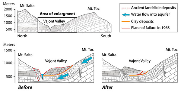
Kathleen Cantner, AGI, after Semenza et al., Bulletin of Engineering Geology (2000).
The Vajont (or Vaiont in English) catastrophe resulted from the fateful intersection of economic needs, political ambition and geologic instability. Although construction of the Vajont Valley Dam did not begin until 1959, the project was conceived during Benito Mussolini’s reign in the 1920s as a way to modernize the sleepy northeastern corner of Italy and provide hydropower for Milan and other growing cities.
Engineers identified the deep, narrow gorge where the Piave River flows through the Vajont Valley as an ideal place for a dam. The valley cuts through limestone along the axis of a syncline (a concave-upward fold in layered rock), so the strata along its walls rest at steep angles, shallowing toward the valley floor. Engineers predicted this structure would have a stabilizing effect that they referred to as “chair-like” — lower slopes would hold the steep upper slopes in place.
This assessment was largely correct, at least for the dam location that was originally proposed in the 1920s. However, after decades of consideration while the chaos of World War II precluded construction, planners instead opted for the greater capacity offered by another natural constriction farther down the valley. Here, the north slope of Mt. Toc spilled over toward the southern flank of Mt. Salta immediately above a narrow slot canyon leading down to the wide Piave River valley. Built here, a dam just 160 meters wide and 250 meters tall could trap 150 million cubic meters of water behind it. Unfortunately, the project was already underway by the time geologists identified the origin of this constriction: an ancient landslide of Mt. Toc.
This information came to light when the Adriatic Energy Corporation (whose acronym is SADE in Italian) hired a team to survey the area during the dam’s construction. A German engineer named Leopold Müller and two Italian geologists, Eduardo Semenza and Franco Giudici, studied the valley and concluded that the slopes above the reservoir were unstable and that the ancient slide could move again. However, their warnings fell on deaf ears; by then, dam construction was nearly completed.
To quell the public’s growing anxiety, SADE assured residents that any potential landslides would be small and could be managed by careful manipulation of water levels in the reservoir. The dam operators knew that raising the water levels could increase the risk of landslides because it would elevate the water table, saturating the soils that held the mountainside in place and lubricating old fractures.
In October 1960, six months after engineers began filling the reservoir, a fracture more than two kilometers long ripped open along the mountainside, and scientists began to measure ground movements of millimeters per day on the south side of the reservoir. A month later, with the reservoir only half full, 700,000 cubic meters of earth from the south shore collapsed into the lake, producing a two-meter wave and prompting engineers to lower the water level again.
After the slide, dam operators cautiously resumed filling the reservoir, hoping that a gradual approach would stave off further instability. Based on the surveys he conducted during construction, Müller advised that the slope would be weakest during the first inundation, and promoted a plan of raising and lowering the water multip"e times before filling the reservoir permanently.
By 1961, it became clear that Müller’s plan had not worked. Residents reported increased earthquake activity, and the south wall continued to encroach on the reservoir now at rates exceeding two centimeters per day. Engineers and geologists recognized that a large slide was possible, and that, in Müller’s words, preventing it lay “beyond human bounds.” As a precaution, SADE installed a tunnel to allow water from the reservoir to reach the turbines in the event that a landslide formed a natural dam upstream of the power plant, dividing the reservoir in two. They also lowered the water level again and agreed to keep it 25 meters below the top of the dam, which seemed an ample margin of safety to prevent floodwaters from overtopping its walls.
On Oct. 9, 1963, the water level had somehow crept above the 25-meter threshold. But the buffer would have offered little protection anyhow from the 260 million cubic meters of hillslope that collapsed into the reservoir that night. The wave generated by the colossal landslide of Mt. Toc’s north slope ran 250 meters up the opposite wall of the valley, killing residents of a small alpine village.
The water then careened over the top of the dam, cascaded down the 250-meter face and dropped another 250 meters into the valley below. The pastoral villages of the Piave Valley were swept away in a matter of minutes, killing families as they slept and leaving those who survived homeless and displaced. Many of the fatalities occurred in Longarone, a small village that still stands in the shadow of the Vajont Dam, which survived the disaster unscathed. The bypass tunnel is now used to generate hydroelectric power.
Public discourse after the fact was sharply divided. SADE and the Italian government maintained that the catastrophe was “an act of God,” while others contended that the early warnings of geologists laid the blame on preventable human error. In 1968, a trial took place in the city of L’Aquila in the central Italian region of Abruzzo, far removed from the carnage of the Piave Valley, and SADE engineers were given a light sentence. The company itself was never sued for damages. (Recently, L’Aquila was again the site of a trial involving geologic hazards when geologists were found guilty of manslaughter for failing to adequately warn the public prior to the 2009 earthquake that killed more than 300 people there.)
The need to understand the physical cause of the slide galvanized a generation of engineering geologists who studied the event exhaustively. They concluded that the ancient landslide reactivated along thin clay layers within the limestone. The interface between these layers and the ancient slide material became saturated by rising water levels in the reservoir, and was further weakened by the presence of two previously unknown aquifers separated by the impermeable clays. These aquifers likely experienced pressure differences at the time of the slide, contributing to the instability. The astonishing speed of the slide itself — which happened in less than a minute — remains poorly understood; the strength of the sliding layer must have decreased dramatically to account for the observed slide velocities of 30 meters per second, but scientists still debate how this might have happened.
Overall, the scientific literature is equivocal about whether the scope and severity of the landslide could have been predicted. Eduardo Semenza, one of the original geologists to map and warn of the ancient landslide on Mt. Toc before the disaster, stated in a 2005 paper that Müller “identified many of the problems but did not have the benefit of the detailed investigations that would be undertaken today.” However, most geologists agree that insufficient studies took place before the project began. The tragedy of Vajont helped standardize the far more rigorous geologic characterizations of construction sites that are common around the world today.
This month, engineers and geologists from around the world will gather at the Vajont Conference in nearby Padua to commemorate the 50th anniversary of the disaster, to reflect on the advances in geologic hazard assessments that have happened since, and to be reminded of the tremendous importance of understanding the impact of human activities on the landscape.
© 2008-2021. All rights reserved. Any copying, redistribution or retransmission of any of the contents of this service without the expressed written permission of the American Geosciences Institute is expressly prohibited. Click here for all copyright requests.