
by Bethany Augliere Thursday, October 20, 2016
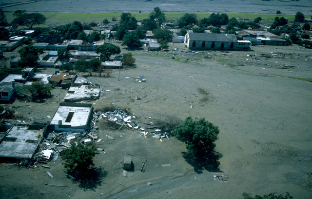
The 1985 eruption of Nevado del Ruiz in Colombia unleashed deadly lahars that swept through Armero, killing 20,000 people in that town alone. Credit: U.S. Geological Survey.
On Nov. 13, 1985, at a little after 9 p.m. local time, Nevado del Ruiz, a volcano about 130 kilometers from Colombia’s capital city of Bogotá, erupted, spewing a violent mix of hot ash and lava into the atmosphere. Less than three hours later, the earth rumbled as mudflows towering nearly 30 meters high swept through the countryside, several villages and eventually the town of Armero, where it killed 70 percent of the town’s residents. All-told, these mudflows, called lahars, killed more than 23,000 people.
Although it wasn’t considered a large eruption, heat melted snow and ice from a glacier capping the volcano and unleashed three lahars — a mixture of rock, volcanic debris, mud and water. The lahars roared down the volcano’s flanks at 30 kilometers per hour, picking up everything in their path, including trees and vehicles, as well as sediment and water from the rivers whose paths they followed. Ultimately, the lahars pulverized and entombed the towns in their wake. The next day, several more eruptions occurred.
The 1985 eruption of Nevado del Ruiz was Colombia’s worst natural disaster, the second-deadliest volcanic disaster of the 20th century (behind the 1902 eruption of Mount Pelée in Martinque) and the fourth-deadliest in recorded history.
In many ways, the eruption did not come as a surprise, wrote Barry Voight, then a geologist at Penn State University, in an analysis of the event. But, despite that, emergency management failed, causing unnecessary loss of life.
In the wake of the tragedy, two agencies — the U.S. Geological Survey (USGS) and the U.S. Agency for International Development’s Office of U.S. Foreign Disaster Assistance — came together to launch the international Volcano Disaster Assistance Program (VDAP) to track and monitor the world’s 1,550 potentially active volcanoes. Since its inception 30 years ago, VDAP has aided in more than 30 international crises, including the 2007 eruption of Nevado del Huila in Colombia, during which 4,000 people were safely evacuated.
“Ruiz is an absolutely seminal event in modern volcanology by virtue of demonstrating the hazards of long-reaching lahars from snow- and ice-clad volcanoes,” says Jeffrey Marso, a geologist with USGS and VDAP team member who went to Colombia in the days after the eruption. “We now know,” he says, “that a relatively small eruption on a high snow- and ice-clad volcano can produce lahars that threaten populations many tens of kilometers away.”
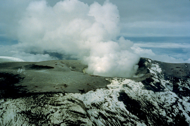
The summit crater of Nevado del Ruiz in late November 1985. Credit: U.S. Geological Survey.
Nevado del Ruiz is a large stratovolcano, similar to Washington’s Mount St. Helens and Mount Rainier, reaching more than 5,300 meters above sea level and topped by glaciers. “Nevado” means “snow-capped.” It’s one of the northernmost volcanoes in the Andean Volcanic Belt, a volcano chain running along the western coast of South America. Ruiz is the second-highest volcano in Colombia and sits in the Los Nevados National Park, which is home to seven other volcanoes.
In recorded history, Ruiz had two notable eruptive events. In 1595, three Plinian eruptions killed 636 people when a lahar swept down the nearby river valleys. In 1845, 250 years later, mudflows again flooded the upper valley of the Lagunillas River, killing more than 1,000 people.
Ruiz began stirring again nearly a year prior to the 1985 eruption, with early activity marked by earthquakes and fumarolic activity. In November 1984, climbers on the mountain reported gas emerging from the summit crater. In December, three earthquakes were felt within 20 to 30 kilometers of Ruiz. This activity continued into the next year.
So, in early 1985, emergency planning began. Geothermal researchers for the Central Hidroeléctrica de Caldas (Chec) visited the summit in January and noticed a new pit in the bottom of the crater had developed. In response, a civic committee formed in the closest large city, Manizales, with the support of Chec and local government, to monitor Ruiz. But, on Feb. 23, the region’s only seismograph broke.
In March, three geologists, including John Tomblin, a seismologist from the United Nations Office of Disaster Relief, visited the area at the request of Colombia’s civil defense agency. “The abnormal activity at Volcán Ruiz corresponds to typical precursory events for an eruption of magnitude,” Tomblin concluded, after witnessing vapor columns hundreds of meters high. He recommended the immediate installation of a seismograph and the preparation of a hazard map.
In the meantime, the Colombian Institute of Geology and Mining (INGEOMINAS) requested seismographs, other equipment and technical expertise from local companies as well as several countries, including the U.S., Costa Rica, Ecuador and Mexico. A Colombian electric company and Costa Rica sent seismographs and some other equipment, and USGS sent additional equipment to help operate the seismographs. The USGS Deputy Chief for Latin America wrote in a note to the United Nations Disaster Relief Organization: “The opportunity is clear, and it is unfortunate that we can spare no one from the Hawaii or Cascades Observatories. … If the volcano is to blow, let us hope that both we and the Colombians are prepared.”
On Aug. 8, the Swiss Disaster Relief Corps and Swiss Seismological Service sent seismologist Bruno Martinelli to provide technical support. The four seismographs sent by Costa Rica and the Colombian electric company had been poorly located, he noted in written communication. Once they were relocated, he wrote, “the seismic system could be considered to be suitable for monitoring the volcano.”
On Sept. 11, Ruiz blew gas and steam in a phreatic eruption for seven hours, but no magmatic eruption followed. It caught the attention of the government, however, which began to develop a response plan. Scientists began working to develop a draft of a volcanic hazard map. The dangers of lahars were obvious. Martinelli viewed the map before leaving and wrote: “The danger of lahars, especially along the Rio Azufrado and Lagunillas, was the guiding theme of this work.”
On the night of the deadly eruption, everything should have been in place to evacuate. Before leaving Manizales in September, Martinelli commented that he “was convinced that everything would be done to limit the possible damage.”
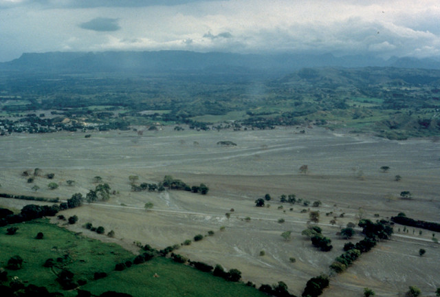
Lahars devastated the region, destroying everything in their paths: homes, agricultural fields, schools and roads. Credit: U.S. Geological Survey.
At 3 p.m. on Nov. 13, 1985, Ruiz sent up steam and gas in another phreatic eruption. Then it settled, and the rain started. This had happened before without a major eruption and “there was no clear instrumental indication in the following hours that a bigger eruption was coming,” Marso says. “In general, the Colombians knew an eruption was possible, but didn’t have hours and hours of warning that it was coming,” he says. Local authorities met, but with no way to forecast the next eruption, no clear, authoritative evacuation was ordered. Six hours later, the situation turned serious when a magmatic eruption started. Once an eruption starts, Marso says, “there’s a fixed time frame for evacuation — at that point, the clock was ticking.”
In Manizales, scientists and officials detected the eruption as soon as it began at 9:09 p.m. However, Marso says, “it turns out there was just too little time.” After a 20-minute magmatic eruption, it took just an hour for the first lahar to reach the closest town of Chinchiná. There, a thousand people lost their lives, and 200 houses and three bridges were destroyed. The first lahar reached Armero about 11:30 p.m., with more lahars following; there, they killed more than 20,000 of the town’s 29,000 residents and left another 5,000 injured.
The lahars destroyed everything in their paths: roads, bridges, farm fields, aqueducts and telephone lines. They wiped out 50 schools, two hospitals and more than 5,000 homes. The region lost 60 percent of its livestock, 30 percent of grain and rice crops, and half a million bags of coffee. About 7,500 people were left homeless.
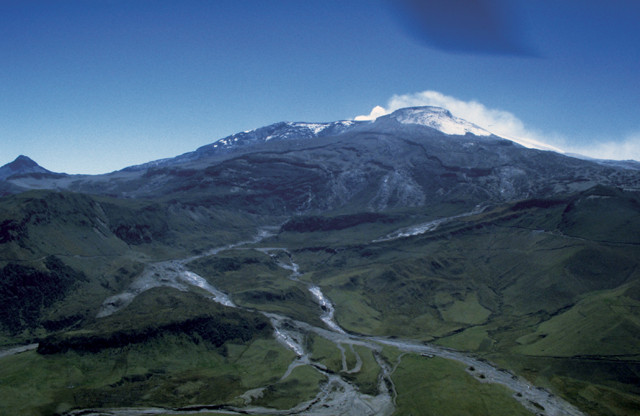
The lahars descended through the steep, narrow drainages and river canyons on Nevado del Ruiz at speeds reaching 50 kilometers per hour. Credit: U.S. Geological Survey.
Marso, who arrived a couple of days after the eruption with two other scientists, describes it as a frenetic and chaotic time. “There was a lot of ash and mud on the landscape,” he says. The U.S. military came to aid in search and rescue operations. “Once we got there, our primary focus was to quickly establish monitoring, because at that point, we didn’t really know what had happened — or what could happen,” Marso says. Even after the eruption, he says, some 90 percent of the ice was still at the summit. If more, or larger, eruptions were to occur, even more people — including those involved in search and rescue — would be endangered. “We spent quite a lot of time flying, putting instruments in the field.” Eventually, other scientists across disciplines showed up to study the volcano.
Volcano emergency management is not easy, Marso says. It takes communication and trust among scientists, local residents and government officials. “In the case of Ruiz, it almost worked perfectly,” says Marso, until it didn’t. In the aftermath, researchers realized that one of the biggest problems was that Armero and the towns nearest the volcano were without power so communication broke down; the scientists had no ability to alert the townspeople to evacuate. With two hours and 21 minutes between the eruption and the first lahar reaching Armero, the town could have been evacuated if communication systems had worked.
“A good partnership between science and civil authorities is essential to protecting people,” Marso says. The Ruiz eruption was a lesson for the world, and resulted in the formation of VDAP. Before Ruiz, a few scientists had been pushing to make a response team happen, but the question was how to fund it, Marso says. “Ruiz made it easier.” Now, VDAP maintains a response team and cache of equipment to respond quickly.
When Mount Pinatubo in the Philippines began to awaken in April 1991, VDAP responded. At the time, most officials thought that Pinatubo was not active and that an eruption would not be dangerous. However, by the third week of April, VDAP sent in a three-person team with monitoring gear. In collaboration with local scientists from the Philippine Institute of Volcanology and Seismology (PHIVOLCS), the team set up a network of seismometers and various instruments around Pinatubo to determine if an eruption was imminent. At the same time, scientists worked to understand the eruptive history of Pinatubo.
As activity increased, and an eruption became more likely, the teams developed response plans and hazard maps. When Pinatubo erupted on June 15, the surrounding area had already been evacuated. In total, about 300 people were killed, but 5,000 could have been. Pinatubo was the second-largest eruption of the 20th century (behind the 1912 eruption of Alaska’s Novarupta), but the combined PHIVOLCS-USGS team had forewarned emergency managers, who had moved most people out of harm’s way.
Colombia, in particular, did not want this kind of tragedy to repeat itself and made serious efforts to prevent it from happening again, Marso says. In 2007, Nevado del Huila — the highest volcano in Colombia — reactivated. VDAP assisted the local INGEOMINAS volcano observatory (now called the Servicio Geológico Colombiano) to improve the monitoring network. In 2008, when the volcano erupted at 9:45 p.m., more than 4,000 people were evacuated from the nearby town of Belalcázar. When a lahar swept through the town less than an hour later, no one was killed. “It was an amazing success, and a testament to the work done in Colombia, with assistance from the U.S., VDAP and other organizations, to see that crises do not become disasters,” Marso says. In 2008, “the Colombians got it absolutely right.”
Nevado del Ruiz hasn’t produced a catastrophic eruption since 1985, though it remains active. Early in 2016, a magnitude-2.9 earthquake occurred under the volcano. And, throughout this year, Ruiz has ejected occasional ash emissions, some reaching up to 1 kilometer high. Today, Marso says, “it’s probably one of the best-monitored volcanoes in the world.”
© 2008-2021. All rights reserved. Any copying, redistribution or retransmission of any of the contents of this service without the expressed written permission of the American Geosciences Institute is expressly prohibited. Click here for all copyright requests.