
by Lucas Joel Friday, October 23, 2015
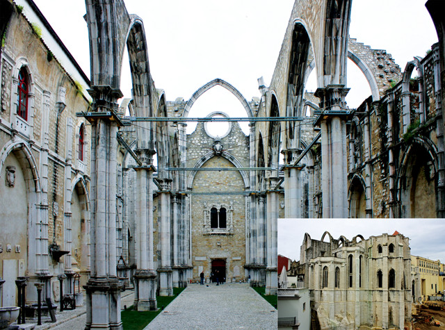
Much of Carmo Convent, including most of the nave, was destroyed in 1755, but the church still stands today as an archaeological museum and a reminder of the damaging earthquake. Credit: both: Trevor Huxham, CC BY-NC-ND-2.0.
Today, the Carmo Convent in Lisbon, Portugal, stands half destroyed; the walls remain, but the roof has been gone for 260 years. On the morning of Nov. 1, 1755, the church was packed with people attending mass for All Saints’ Day, a Catholic holiday. At about 9:30 a.m., the ground heaved, and the church’s roof fell. A magnitude-8.7 earthquake had struck. Churchgoers not crushed by falling debris fled into the streets. Across the city, candles, stoves and oil lamps fell, igniting fires that eventually burned down about half the city. Along with the shaking, the fires drove people to the banks of the Tagus River — Lisbon’s main river — and to the city’s harbor, where many boarded ships in search of safety. About 45 minutes after the shaking began, however, a 5- to 10-meter-tall tsunami entered the Tagus from the Atlantic Ocean, smashing ships against one another and against the sea walls surrounding the city.
The quake, known as the “Great Lisbon Earthquake,” killed an estimated 70,000 people, making it the worst natural disaster in recorded European history. Shaking caused church bells to clang as far away as Austria, and along the coast of Morocco the tsunami breached 8-meter-high walls. The event, recounted in several eyewitness reports, sparked shifts in Western philosophical thought, and helped give birth to the field of seismology.
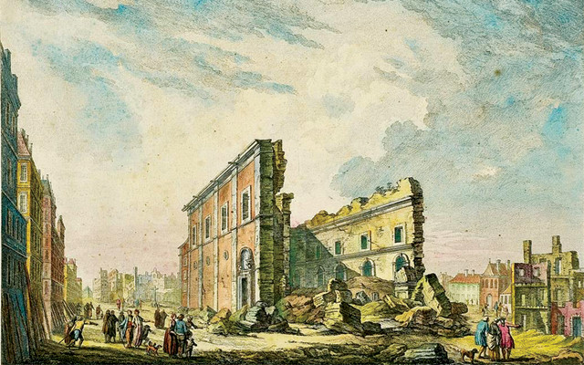
The ruins of St. Paul's Church following the quake. Credit: Jacques-Philippe Le Bas.
On the morning of the Great Lisbon Quake, Rev. Charles Davy was writing a letter on the first floor of his apartment when the shaking began. In his account, Davy describes first feeling a “tremble with a gentle motion,” which he found surprising due to the lack of wind that day. Then “the whole house began to shake from the very foundation,” followed by a large noise underground. “All this passed in less than a minute … and it naturally occurred to me that the noise might possibly be the forerunner of an earthquake,” Davy wrote.
The quake’s epicenter was about 200 kilometers southwest of Lisbon, most likely along the complex tectonic boundary between the African and Eurasian plates, which also includes subducting Atlantic Oceanic crust. Here, the African Plate moves northward at about 4 millimeters per year, while the oceanic crust subducts beneath the Straits of Gibraltar.
“This particular plate boundary is moving very slowly, making it hard to pinpoint exactly where the Lisbon quake’s origin was,” says Marc-André Gutscher, a geophysicist at the University of Western Brittany in France. However, he says, “the quake, in order for it to have generated a tsunami, had to deform the seafloor, so it needs to have been shallow, likely between 10 and 30 kilometers depth.” A shallow hypocenter also explains why the quake was felt at such great distances, Gutscher says.
Later in his account, Davy describes how, after the initial shaking, his house was “instantly stunned with a most horrid crash, as if every edifice in the city had tumbled down at once. The house I was in shook with such violence, that the upper stories immediately fell.” Three major shocks struck in the ensuing 10 minutes, and large fissures — some reportedly 5 meters wide — opened near the city’s center.
The first shock Davy felt came from primary earthquake waves, or “P” waves. These were followed by secondary, or “S” waves, which arrive after P waves because they move more slowly through Earth. S waves generally cause more shaking and, thus, damage than P waves, and they are what Davy most likely experienced when his apartment building collapsed.
Davy emerged from the destroyed building, climbed over the ruins of St. Paul’s Church, and headed to the Tagus River. Buildings continued to fall around him, and people who had survived the initial jolts filled the streets. Cries of “misercordia meu Dios!” (“mercy, my God!”) came from all around, Davy recalled. Then the third shock arrived, “and completed the ruin of those buildings which had already been much shattered.” A parish church atop nearby St. Catherine’s Hill crumbled, killing or wounding those who had retreated there. Flames spread across Lisbon. Fallen debris blocking narrow streets made it difficult to access and extinguish the flames.
Other accounts also describe three distinct jolts. This has confounded seismologists like Gutscher because the third jolt seems to have occurred many minutes after the initial jolts caused by the P and S waves. According to Gutscher, the third jolt implies that there may have been more than one fault that ruptured that day along the African and Eurasian plate boundary. “The P and S waves could explain the initial shaking events,” such as those Davy experienced in his apartment, Gutscher says. “But it can’t explain the third, which happened several minutes after the first two. This suggests that probably at least two faults were involved,” which may mean two different quakes were triggered. Seismologists are still studying this event, hoping to determine exactly what happened during the Great Lisbon event in order to better assess the future seismic risk to the region.
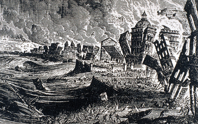
This wood engraving from 1887 depicts Lisbon along the bank of the Tagus River, with houses "exploding into fire, turbulent water, sinking ship, people fleeing," as was described at the time. Credit: Kozak Collection, NISEE, University of California, Berkeley.
Davy watched Lisbon’s destruction from near the Tagus. Then he says he heard more cries: “The sea is coming, we shall all be lost!” Davy saw “at some small distance, a large body of water, rising as it were like a mountain. It came on foaming and roaring … we all immediately ran for our lives as fast as possible.” The water in the Tagus had receded, exposing the riverbed. A tsunami was about to make landfall. At about 10:10 a.m., the tsunami hit, destroying the harbor and sweeping away thousands.
The tsunami also traveled across the Atlantic: a 3- to 5-meter-high wave struck Antigua, while a 1- to 2-meter-tall wave swept onto the shores of many other Caribbean islands. Today, sediments still record the tsunami’s effects. In the Bay of Cádiz in southern Spain, a sand spit called Valdelagrana preserves coarse-grained washover sands dating to roughly 260 years ago — coeval with the 1755 quake. The spit, which is very rarely breached, even by the strongest storms, preserves similar deposits that date to about 218 B.C., when Romans ruled the region. In the marine sedimentary record, coarse-grained sandy turbidites deposited in abyssal plain settings occur during the same time intervals. “Others have shown that there have been about 15 turbidite sequences deposited in the region over the past 35,000 years,” Gutscher says. “If it turns out each turbidite sequence was deposited due to an earthquake, then that would mean earthquakes there of that size have a recurrence interval between 1,500 and 2,000 years.”
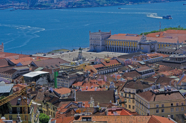
This city square, Praça do Comércio, otherwise known as the Terreiro do Paço, is the former site of the royal palace in Lisbon. It was destroyed in the earthquake and not rebuilt at the same location. Instead the former palace grounds became part of the new city center. Credit: Ken and Nyetta, CC BY 2.0.
After the earthquake, Portugal’s King Joseph I commissioned Sebastião José de Carvalho e Melo — later given the title Marquis de Pombal — to supervise and coordinate recovery efforts. Corpses were buried en masse or ferried out to sea to avoid an epidemic, and new building practices were put into place; prior to construction, models of buildings were first built and tested to gauge their resistance to earthquake shaking, which was simulated by groups of Portuguese troops marching around the models. Today, many buildings in Lisbon stand as some of the world’s first structures built to be earthquake-resistant.
Pombal also ordered surveys to be sent to parishes across the country. The questions in the survey included: How many aftershocks were felt? What kind of damage was caused? How long did the earthquake last? Did the shaking come from one direction? What happened to the wells and water? The answers to these questions have helped modern seismologists construct isoseismal maps, which depict the varying levels of shaking in a region during an earthquake. Shaking levels correlate with the Modified Mercalli Scale, which seismologists use today to describe shaking intensities on a scale from I to XII, I being barely detectable and XII denoting extreme shaking. Researchers currently think that the shaking in Lisbon in 1755 reached level X, while cities in Morocco experienced level-IX shaking. The strongest shaking, reaching level XI, occurred near the Algarve along Portugal’s southern coast, indicating the quake’s epicenter was near this region. Pombal’s investigations into the nature of the earthquake — along with the instigation of new building practices — are thought by some to mark the beginnings of the scientific study of seismology.
When the shaking and the burning subsided in Lisbon, Davy, who survived, wrote that “this extensive and opulent city is now nothing but a vast heap of ruins; that the rich and poor are at present upon a level.” Today, though, buildings erected under Pombal’s governance — designed with earthquakes in mind — stand in many of Lisbon’s downtown squares, and the roofless Carmo Convent is one of the only reminders of the city’s destruction.
© 2008-2021. All rights reserved. Any copying, redistribution or retransmission of any of the contents of this service without the expressed written permission of the American Geosciences Institute is expressly prohibited. Click here for all copyright requests.