
by Sara E. Pratt Thursday, February 20, 2014
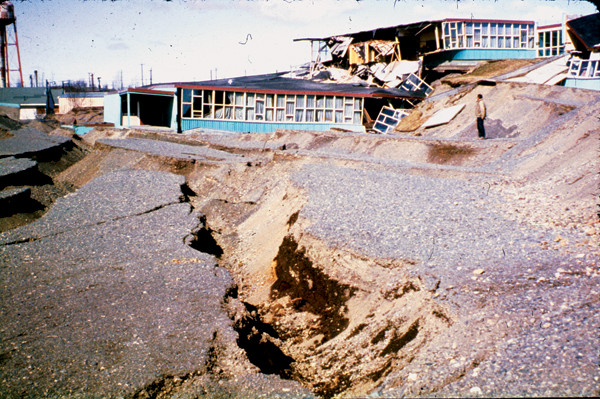
Government Hill Elementary School in Anchorage was destroyed by the Government Hill landslide during the earthquake. USGS Photographic Library
During the Cold War, many Americans lived in fear of the day their town would be shaken by an atomic bomb blast. On Good Friday 1964, some Alaskans thought that day had come.
At 5:36 p.m. on March 27, 1964, a magnitude-9.2 earthquake, the most powerful quake ever recorded in North America, struck 22.5 kilometers beneath Prince William Sound, where the Pacific Plate is subducting beneath the North American Plate along the 3,400-kilometer-long Aleutian Trench. The massive quake — second in size globally to only the 1960 magnitude-9.5 quake in Chile — and the tsunamis it generated killed 131 people.
Intense ground shaking continued for almost five minutes as the 800-kilometer-long rupture propagated, releasing the equivalent seismic energy of a cascade of nearly 2,000 magnitude-7 quakes. The ground shaking — which was felt over an area of more than 1.3 million square kilometers — was so intense and long-lived that some survivors later said they first thought the Soviet Union had dropped a nuclear bomb on Anchorage, 120 kilometers northwest of the epicenter.
Significant tectonic deformation occurred over an area of more than 200,000 square kilometers, leaving an estimated $500 million in property damage ($3.75 billion in 2013 dollars). On the Modified Mercalli intensity scale — which ranges from I (not felt and no damage) to XII (widespread destruction and high death toll) — the 1964 Alaska quake registered an XI.
The quake caused noticeable vertical displacement, with uplift reaching 10 meters in some areas east of Kodiak and subsidence of almost 3 meters elsewhere. The town of Portage, at the head of Turnagain Arm, sunk nearly 2 meters, causing the shoreline to advance 3.4 kilometers farther inland and swamping the town.
In Anchorage, buildings swayed, trees smacked the ground, and fissures opened in the streets, swallowing vehicles whole and ejecting geysers of sand and water. The J.C. Penney department store, the Four Seasons apartment building, and Government Hill Elementary School collapsed. The apartment building and school were unoccupied, but two people died and one was injured at J.C. Penney.
The quake triggered avalanches, rockfalls, landslides and slumps over a widespread region. Most of the failure occurred in a single sedimentary stratum, the Pleistocene-aged glaciolacustrine Bootlegger Cove Formation composed of interspersed clay, sand and silt layers. Later geological analyses concluded that the prolonged shaking had induced soil liquefaction in the formation’s silt and sand lenses, destabilizing the overlying layers and the structures built upon them.
Along Knik Arm, a branch of Cook Inlet, massive landslides wiped out entire neighborhoods, including the Turnagain Heights subdivision, where a local doctor, Perry Mead, his wife Wanda, a teacher, and their five children lived. At the time of the quake, the children were home alone while their father was at work and their mother was doing the shopping for the Easter holiday weekend. When the shaking began, the four older children fled the house, but after realizing their 2-year-old brother was still inside, 12-year-old Perry Jr. re-entered the house to get him just as the bluff collapsed into Knik Arm. The bodies of the two children were never found.
In all, 131 people were killed: 115 in Alaska and 16 in Oregon and California. Although tragic, for a quake this size, the death toll was low. Despite massive and widespread destruction of buildings, homes, roads, bridges and railways, only nine of the 131 fatalities were directly caused by the earthquake. Authorities attributed this to three factors: most of the affected area was sparsely populated, most structures were built of wood, and the quake struck during the fishing offseason and on a Friday evening before the Easter holiday weekend when most schools and offices were empty.
The larger death toll was caused by the subsequent tsunamis, both local ones generated by landslides and the main open-ocean tsunami generated by seafloor uplift.
Eighty-two people were killed by the local tsunamis, massive waves generated by landslides both above and below the water line in harbors, bays, inlets and fjords. Local tsunamis struck the towns of Seward, Whittier, Kachemak Bay and the port town of Valdez, which experienced two tsunamis. The highest wave height, 67 meters, was recorded in Shoup Bay in Valdez Inlet.
The tsunamis were especially destructive in Valdez, the U.S.’s northernmost ice-free port at the time, which lay 80 kilometers east of the epicenter. On the day of the quake, the first supply ship to arrive in Valdez after the spring thaw, the S.S. Chena, had docked at 4 p.m., and longshoremen had begun unloading cargo. Twenty-eight people were on the dock, including some of the longshoremen’s children, who had come down to see the ship because the crew would often toss out candy to onlookers. Two of the Chena’s crew members were filming the scene with their 8-millimeter cameras when the earthquake and subsequent tsunami struck, providing some of the only film of the catastrophe as it unfolded. (Clips of the actual footage are included in a film that can be viewed on YouTube at: http://bit.ly/1dLSBvl.)
The footage shows water first being sucked out of the harbor and then the devastating inundation that followed, and captures evidence of the submarine landslide, including a maelstrom forming in the harbor, which swallowed part of the dock and sucked the Chena down with it. The waves sloshing in and out of the harbor severely pitched the ship and repeatedly slammed it to the bottom of the harbor. Two longshoremen working inside the ship were crushed to death by sliding cargo and a third was critically injured, requiring the later amputation of both feet. Although the ship and her crew survived, something the captain later called “miraculous,” the longshoremen on the dock and their children did not.
The Valdez waterfront was home to both Standard Oil’s and Union Oil’s tank farms, which exploded and burned for two weeks, belching black soot into the sky and exacerbating the apocalyptic scene. Tidal bores, carrying chunks of ice and debris, continued arriving into the early morning hours the next day.
With 31 dead, Valdez had the most fatalities of any town, but the native village of Chenega — on an island in Prince William Sound where the first waves struck within minutes of the quake and the maximum wave height reached 27.3 meters — lost the largest proportion of its population, with 23 of its 76 residents killed.
In Seward, a 1,000-meter stretch of waterfront slid into Resurrection Harbor, triggering a local tsunami that wiped out oil tanks, spreading burning oil on the water’s surface. Twenty minutes later, the larger main tsunami struck, killing many fishermen who had gone down to the harbor to check on their boats after the quake and first inundation.
The main tsunami was generated when the Aleutian Fault — where the North American Plate was locked by friction against the subducting Pacific Plate — ruptured. The North American Plate, which was being compressed and shortened by the subduction, rebounded, uplifting the seafloor 15 meters. The shock unleashed a wave that propagated across the Pacific Ocean and even into other ocean basins.
Traveling south, the main tsunami waves struck Oregon, where Monte and Rita McKenzie of Tacoma, Wash., were camping with their four children at Beverly Beach State Park near Newport, Ore. The children were tucked into sleeping bags when the first wave hit. At first, the parents were able to gather the children, but the family was separated again by subsequent waves. All four McKenzie children were swept away and killed, along with the family dog. Twelve more people were killed when the waves hit Crescent City, Calif., where the offshore bathymetry and shape of the harbor notoriously focus tsunami waves. (The town was also the site of a fatality from the March 2011 Tohoku earthquake and tsunami.) In 1964, four waves ranging up to 7 meters in height surged into Crescent City, destroying the main business district and igniting a Texaco oil tank farm, which burned for three days. Total damage to the town was estimated at $7.5 million ($55 million in 2013 dollars).
Damage was noted as far away as Louisiana, where waves swamped and sunk several fishing boats. Small but detectable water-level changes were recorded in Antarctica.
After the currents subsided, boats that had weathered the tsunami at sea returned to harbors to rescue residents who, though wet and injured in some cases, had made it to higher ground and had survived the freezing night with whatever supplies they had been able to grab. In the days following the disaster, military and civilian defense personnel arrived in Alaska, establishing field hospitals and kitchens, and evacuating residents from the hardest-hit towns.
It took months to clean up the debris and years to rebuild the infrastructure damaged by the quake. Today, in Anchorage, one can still see the effects on the landscape. Part of the Turnagain Heights slide was turned into a memorial called Earthquake Park. Many of the native villages along the sound were rebuilt on higher ground, as was Valdez, which was moved to a new location at a cost of $37.5 million dollars ($277 million in 2013 dollars) and is again functioning as a vital oil transportation hub.
In 1964, plate tectonics was still a new idea and not fully understood. The Alaskan quake — the visible uplift, subsidence and ground deformation and the unseen but measured seismic signals — provided invaluable data to geologists assembling the theory of plate tectonics. In one study of the quake, U.S. Geological Survey geologist George Plafker suggested that “underthrusting of the oceanic crust and mantle beneath the continental margin” could explain the observed deformation and stress, elucidating the process of subduction. The event contributed to the nascent understanding of megathrust earthquakes, the threat they pose and the need to monitor them. In 1964, there were only two seismometers in Alaska; today, there are hundreds of seismic and GPS stations.
Perhaps one of the largest impacts of the earthquake and resulting tsunamis, however, was the establishment, in 1967, of the West Coast and Alaska Tsunami Warning Center in Palmer, Alaska. The initial mission of the center, part of NOAA and the National Weather Service, was monitoring earthquakes and providing tsunami warnings for Alaska, California, Oregon, Washington, and British Columbia, Canada. It was later expanded to all U.S. states, Puerto Rico and the Virgin Islands, and Canadian provinces with coastlines, with the exception of Hawaii, where the Pacific Tsunami Warning Center is located. In October 2013, the Alaskan center was renamed the National Tsunami Warning Center to reflect its larger role in detecting and warning of tsunamis, especially destructive tsunamis with a global reach like the one experienced on March 27, 1964.
© 2008-2021. All rights reserved. Any copying, redistribution or retransmission of any of the contents of this service without the expressed written permission of the American Geosciences Institute is expressly prohibited. Click here for all copyright requests.