
by Allison Mills Friday, May 8, 2015
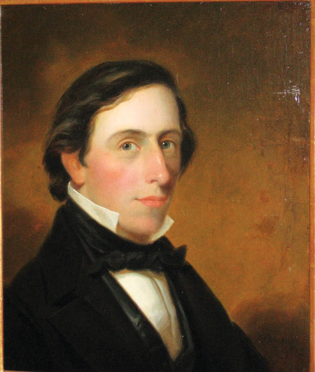
Douglass Houghton's survey of the geology of Michigan's Upper Peninsula led to the nation's first major mining boom. Credit: Painting by Alva Bradish, University of Michigan Archives.
On the morning of June 1, 1840, Michigan’s first state geologist, Douglass Houghton, stepped onto a small barge about to set sail on Lake Superior. The step marked the beginning of the first geological survey of the Keweenaw Peninsula — the northernmost portion of Michigan’s Upper Peninsula, which juts out into the center of the lake. Houghton and his crew would spend the summer exploring Michigan’s Upper Peninsula and recording the region’s geologic resources, including rich copper deposits known only locally at the time. That would change, however, after Houghton’s team detailed its findings in an 1841 report that spurred the nation’s first major mining boom.
Copper from the Keweenaw Peninsula drew not only Houghton and his surveyors, but also a rush of thousands of miners and their families to the remote, rugged land in 1843 and 1844. The deposit, comprising amygdaloidal lodes and veins of native copper, is the largest of its kind in the world. During the century and a half following the boom, millions of metric tons of copper were extracted. Today, native copper and a suite of unusual minerals still abound in this region known as the “Copper Country.”
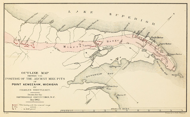
This map of the Keweenaw Peninsula, produced in 1862, details both contemporary mines and earlier mining pits dug by Native Americans. Credit: Charles Whittlesey, Smithsonian Institution.
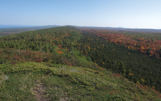
Conifers and maples carpet a ridge formed during rifting of the mid-continent about 1.1 billion years ago. Credit: Drew Cramer.
The Keweenaw area that Houghton explored contains rocks of extreme age, both old and young. Remnants of the Precambrian, older than 1 billion years, and the Pleistocene, less than 3 million years in age, abut in many locations. But it’s the abundance of native copper that makes the local rocks unique: To this day, it remains the only deposit in the world from which native copper has been mined commercially.
The mineral resources of the Keweenaw are thought to have been emplaced during mid-continent rifting, which occurred about a billion years ago and formed what is now the Lake Superior Basin. The rift extends more than 1,500 kilometers and is about 150 kilometers wide. The ancient valley is now filled with thick volcanic flows, a few intrusive dikes and a swath of sedimentary rocks. Although the forces that drove the rifting were complex and continue to be debated, the rocks of the Keweenaw Peninsula leave no doubt that a major geologic event occurred there.
The most notable rifting features are steep ridges that form the spine of the peninsula. Glaciers later carved away the softer rocks, leaving behind resistant, elevated basaltic lava flows. The Greenstone lava flow is one of the largest flows in the world, up to 400 meters thick and running for 90 kilometers along the peninsula. A remnant of the same flow, emplaced on the other side of the rift valley, is exposed to the north on Isle Royale, nearly a hundred kilometers away.
After rift volcanism in the basin ended, the igneous flows and dikes were eroded, reworked and deposited in numerous sedimentary layers that make up much of the Keweenaw Peninsula. Clastic sediments were laid down as conglomerates, then immature sandstones, then a thin, shaly sandstone, all topped by a thick, mature sandstone. The strata were so immensely thick that the area actually subsided under their weight.
Within these sedimentary layers were fissures, gas pockets and pores where copper precipitated from metal-rich hydrothermal fluids. As the copper filled in the gaps, intricate dendrites, which look like metal trees, formed in some spots. Elsewhere, crystalline copper filled in cavities. Copper “skulls” — bowl-shaped basins of metal removed from around large cobbles — are a hallmark of the local conglomerates. Some of the world’s best specimens of native copper have been pulled from the district’s mines. Crystalline silver, copper-filled calcite crystals, chalcocite, copper arsenides and many secondary copper minerals have also been mined from the area. Other minerals in the region are collected for use as gems, including datolite, greenstone (also known as chlorastrolite — Michigan’s state gem) and Lake Superior agates.
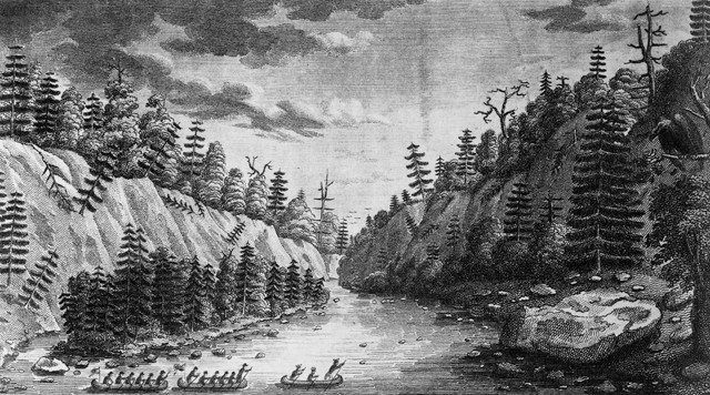
The Ontonagon Boulder (at right), comprised entirely of native copper, took on epic proportions in Henry Schoolcraft's sketch, which shows the stone towering over six-man canoes. Credit: Philip J. Kucera collection.
Copper was just a rumor when Michigan became a state at noon on Jan. 26, 1837. Even so, a mere two hours later, a bill was introduced to form a state geological survey and within a month, Douglass Houghton was appointed the first state geologist with a salary of $3,000 a year."
Houghton’s skill as a geologist was undeniable, but his true talent lay in his ability to promote the value of geological resources within the state legislature. And, at the time, the state government was looking for any reason to see its new acquisition of the Upper Peninsula — considered the shoddy end of a deal to end the 1835 “Toledo War” over the border between Ohio and Michigan — in a positive light.
Houghton’s official report on the Keweenaw’s copper was released in 1841, by which time he had known about the ore for nearly a decade. During the summer of 1832, Houghton had joined Henry Schoolcraft’s expedition following the shores of the Upper Peninsula. Schoolcraft, a mineralogist, toured Lake Superior on an 1819 expedition and was the first scientist to make note of the region’s pervasive copper.
However, the shiny metal had been mined for thousands of years by indigenous tribes in the Great Lakes region, and the Keweenaw is the earliest known site of metalworking in North America. Not much is known about these early groups living on the Keweenaw, but a few artifacts from their time there remain, including a 4,000- to 6,000-year-old <a href=“http://www.mtu.e"u/news/stories/2013/november/ancient-copper-spear-point-special-exhibit-seaman-mineral-museum.html”>copper spear point found on a beach in 2011 and evidence of mining-related pollution dating back 8,000 years. More recently, Ojibwe tribes dug numerous pits that still dot the peninsula’s shores and ridges.
The Ojibwe also first introduced Schoolcraft to the Ontonagon Boulder in 1819. The boulder is pure copper, weighing a hefty 1.4 metric tons. Awed by its size and metallic composition, Schoolcraft drew a sketch that represented the boulder as far bigger than it actually was. In response, when Houghton saw it decades later, he claimed that the Ontonagon Boulder was a “mere stone, a large pebble.”
Both Julius Eldred, a store owner from Detroit, and the U.S. War Department disagreed with Houghton’s assessment of its value, however. Eldred successfully removed and transported the boulder to Detroit in 1843, w"ere he put it on public display, charging an admission fee. Several years later, the federal government confiscated and moved it to Washington, D.C., leaving it in possession of the War Department. Eventually, the U.S. National Museum took ownership, and today, it rests at the Smithsonian National Museum of Natural History.
Although less enthralled by the Ontonagon Boulder, Houghton was impressed by a site dubbed La Roche Verte, or “green rock” in French. What Houghton saw at La Roche Verte, which is located near present-day Copper Harbor, was a substantial vein of copper ore running through amygdaloidal basalt along the shore. The vein strikes away from land and most of it is beneath the waters of Lake Superior. The site’s apt name originated from the swirling blue-green streaks of oxidized copper minerals in the rock, primarily chrysocolla, a hydrated copper cyclosilicate. Although this brilliant green coloration — which was what sold Houghton on the mining potential in the Keweenaw — is still visible today to an extent, much of the original formation is gone due to the number of souvenir rock samples hacked off over the years.
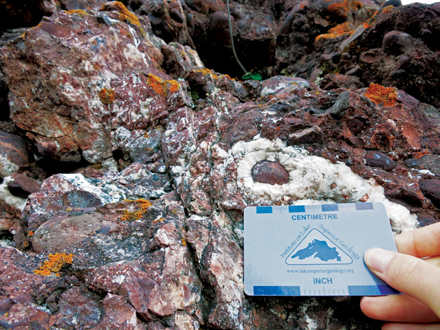
One of the most distinct rock layers in the Keweenaw is the Copper Harbor Conglomerate, which contains rounded cobbles enveloped in calcite, copper and prehnite. Credit: Allison Mills.
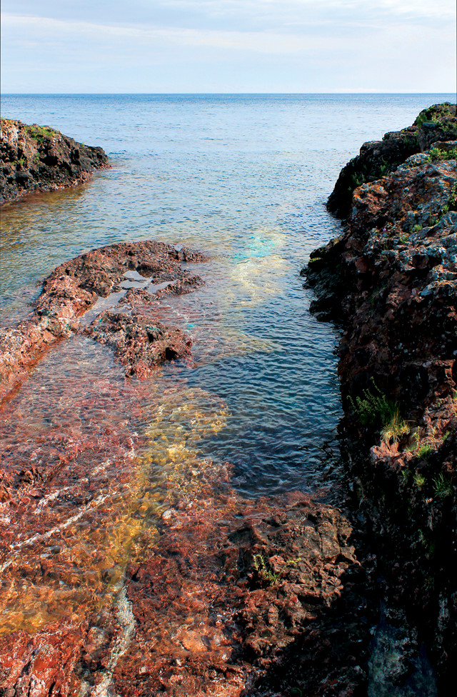
Houghton and his crew landed near present-day Copper Harbor at a site called La Roche Verte, or "the green rock." The blue-green coloration seen at the water's edge is weathered copper. Credit: Frank Hutton, Handmade Images.
As he sailed around Lake Superior in the summer of 1840, Houghton and his team observed a number of copper-bearing rocks in the Keweenaw. His geological survey report, detailing descriptions and locations of the Ontonagon Boulder, La Roche Verte and many other green rocks, was released in 1841 and quickly made headlines. The miners showed up soon after.
The Keweenaw mining boom was unprecedented in the United States. The copper rush predated Sutter’s Mill and the influx of gold-seeking 49ers to California by several years, making it the first major mining boom in the country. Miners from around the world came to the Keweenaw — Italians, Germans, Chinese, Croatians, Poles and Irish among them. Over time, the Finnish community became well-established, perhaps prominently shaping the notable Upper Peninsula, or “Yooper” (as in UP-er), accent of the area’s contemporary residents.
Cornish miners from southwest England also settled in the region and were sought after by mining companies for their particular prowess in copper mining. When Butte, Mont., became a burgeoning mining town later in the 19th century, the largest copper mining companies sent over spies and recruiters to convince the experienced Cornish and Keweenaw copper miners to move west.
The miners and their families built numerous settlements around the peninsula. Some remain, others are rubble, and a few are preserved through the National Park Service’s Keweenaw Heritage Sites. The boomtown of Calumet, then called Red Jacket, was once on the shortlist to become Michigan’s capital city; today the town has a population of about 700 and lies hundreds of kilometers from the city that beat it out to become capital, Lansing. Today, the ghost towns, old mine hoists and stately downtown buildings are reminders of a bygone era.
Even with the mining boom, which lasted through the 1920s, the region remained isolated. Mining was not an easy life, and the Keweenaw settlers had to contend with the harsh reality of short summers and winter snowfalls often topping five meters or more. Still, despite the hardships of climate and early pioneer life, more than 5 million metric tons of copper have been removed from Keweenaw rocks since the 1840s.
Houghton, who had cautioned speculators about booms and their inevitable busts, and sought to continue his surveying work amid the land grab he helped spur, never saw the survey or the mining boom come to full fruition. He died in 1845 in a boating accident just off Eagle Harbor, Mich., while pursuing his geological research in the Keweenaw. Houghton’s legacy lives on, however, in the very name of the Copper Country and in the name of the largest city on the peninsula, Houghton, Mich.
© 2008-2021. All rights reserved. Any copying, redistribution or retransmission of any of the contents of this service without the expressed written permission of the American Geosciences Institute is expressly prohibited. Click here for all copyright requests.