
by Sam Lemonick Wednesday, July 6, 2016
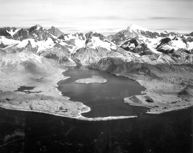
A giant wave was generated in Lituya Bay, Alaska, on July 9, 1958, by a rockslide from the cliff at the head of the bay. The wave destroyed the forest over the light areas to a maximum height of 524 meters. The fishing boat Badger, anchored in the cove at lower left, was carried over the spit in the foreground. The Sunmore, near the bay's entrance, was sunk; the Erdie, anchored near the lower right, rode out the wave. Credit: U.S. Geological Survey.
The recent disaster in Japan demonstrates the incredible destructive power of a megatsunami in a heavily populated area. But a record-breaking tsunami of a different sort occurred in 1958, in a remote part of Alaska known as Lituya Bay — and was witnessed by only six people, two of whom died. The giant tsunami and the unusual geometry of the bay combined to produce the largest wave run-up ever recorded — deluging the steep forested hills along the edges of the bay to a height of 524 meters. The wave was a powerful reminder of the forces nature can unleash.
Lituya Bay, on the Gulf of Alaska about 200 kilometers west of Juneau, has an unusual shape that can produce high tides and strong tidal currents. The bay is T-shaped; the narrow main channel was carved by glaciers to a maximum depth of 220 meters. At the mouth of the bay, the opening is only about 10 meters deep. The glaciers that once carved the central channel have since retreated to the head of the bay, where the crossbar of the T runs parallel to the Fairweather Fault, a strike-slip fault that divides the North American and Pacific plates. Three glaciers flow into the bay: the Lituya and North Crillon glaciers at the northwest and southeast arms of the T, respectively, and the Cascade Glacier between them.
At about 10:15 p.m. on July 9, 1958, a magnitude-7.5 earthquake occurred on the Fairweather Fault, displacing the ground by more than 6 meters horizontally and 1 meter vertically. The earthquake triggered a massive landslide into the waters at the head of the bay. The rock dumped onto the bay’s seafloor formed a large crater; shortly afterward, the impact generated a giant wave. The wave swept through the main channel at 180 kilometers per hour.
Aerial photographs taken after the tsunami show the power of the wave. The shores of the bay are densely forested — except for visible “trimlines,” swaths of shoreline laid bare, with trees hundreds of meters high on the shores, and nearly 2 meters in diameter, sheared off at their bases by the force of the water. Many of these trees were stripped of their branches and bark. Barnacles were ripped from rocks. Mining equipment left at a camp on the shore was washed away, as was a cabin on an island in the bay and a lighthouse at its mouth.
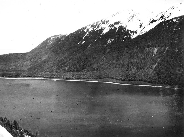
North shore of Lituya Bay in 1953, showing wave trimlines from previous tsunamis in 1853-54 and 1936. Credit: U.S. Geological Survey.
Six people were in Lituya Bay the night of July 9. Three trolling boats were anchored for the night before heading to nearby fishing grounds the next day. Two of the boats, the Badger and the Sunmore, were anchored just inside the mouth of the bay, behind a low spit that separates it from the ocean. A third, the Erdie, was anchored about two kilometers into the bay.
Aboard the Badger, Bill Swanson was shaken awake by the earthquake. He saw the mountains at the head of the bay shaking and rockslides tumbling down their faces, according to a 1960 U.S. Geological Survey (USGS) report about the megatsunami. Swanson also claimed to be able to see Lituya Glacier, normally hidden behind the turn the T-shaped bay takes to the northwest. “I know you can’t ordinarily see the glacier from where I was anchored,” he said in an interview with Alaska Sportsman magazine in 1958. “But I know what I saw that night too.”
The glacier, he said, had “risen several hundred feet” and slid forward so that it was visible from his position. “It was jumping and shaking like crazy,” shedding blocks of ice from its face into the water. After a while, the glacier fell back out of sight. Then Swanson saw the wave coming. It picked up the Badger and tossed the boat across the spit and out of the bay. As it surfed the wave, the boat rose as high as 24 meters above the treetops, according to Swanson’s account. Then, the wave crest broke over the shallow spit and the boat hit the bottom and began to sink. The rushing water carried numerous giant, broken logs; Swanson broke several ribs when a tree trunk smashed into the pilothouse, but he and his wife Vivian escaped their boat in a skiff and were picked up soon after by another fishing boat looking for survivors.
Closer to the head of the bay, on the Erdie, Howard Ulrich and his 8-year-old son were also awakened by the earthquake and saw the shaking and rockslides at the head of the bay. In the 1960 USGS report, Ulrich reported hearing a deafening crash a couple of minutes after he first felt the earthquake. “It was not a wave at first. It was like an explosion,” he said. He confirmed Swanson’s assertion that the wave originated from the northwestern inlet of the T, where Lituya Glacier spills into the bay; the wave, he said, splashed up the mountain slopes as it came around the corner and spread out as it entered the main body of the bay to a height of about 30 meters.
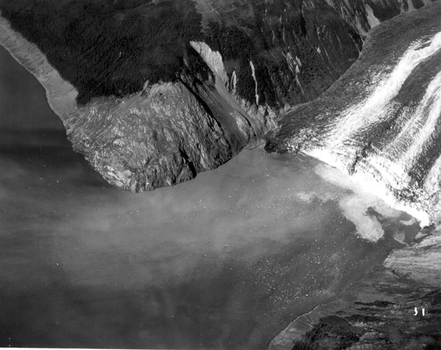
The head of Lituya Bay in August 1958. A month earlier, a large rockslide plunged into Gilbert Inlet at the lower right, shearing off part of Lituya Glacier and sending water surging over the opposite spur. The trimline slopes down to the right, across scars of slides that occurred before the 1958 earthquake. Credit: U.S. Geological Survey.
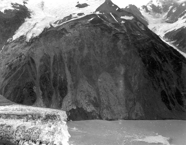
The northeast wall of Gilbert Inlet in August 1958 shows the scar of the rockslide that generated the megatsunami. From just below the snowfield in the upper center, the rocks fell about 1,000 meters into the bay. The front of Lituya Glacier is at the lower left corner. Credit: U.S. Geological Survey.
Ulrich realized he couldn’t haul back the anchor fast enough to get free of the bottom and instead paid out as much chain as he could in the hope that he could ride out the wave. The chain snapped as the tsunami lifted up the boat. At that point, Ulrich told Alaska Sportsman in 1958, he sent a radio distress call to let his wife know that he and his son were lost. Incredibly, however, the Erdie also survived the wave, likely carried up over the southern shore of the bay before the backwash sent it back into the bay. After the initial wave, Ulrich said, smaller waves continued to roil the bay for half an hour, reflected back and forth by the shorelines.
The third boat, the Sunmore, was not so lucky. Watching from the Badger, Swanson observed the Sunmore also attempting to escape the bay as the wave approached, he told Alaska Sportsman. But the Sunmore vanished beneath the wave, taking husband and wife Orville and Mickey Wagner with it.
The precise cause of the giant tsunami of 1958 remained unclear for decades. Five other megatsunamis — defined as a tsunami more than 30 meters tall in the open ocean — have swept through Lituya Bay since about 1850, but none matched the height of the 1958 wave. The author of the 1960 USGS report, geologist Don Miller, noted that he initially thought the earthquake’s motion had created the wave, but after seeing the size of the rockfall he was convinced that the landslide was the cause. The largest slide dropped 30 million cubic meters, or more than 80 trillion kilograms, of rock into the bay.
Several scientists have since modeled the conditions of that day in Lituya Bay to try to determine what happened. In the late 1990s, chemist Charles Mader of Los Alamos National Laboratory modeled several scenarios of possible tsunami generation in Lituya Bay, including ground motion, the rockfall and the possibility that the sudden draining of a glacial lake had induced the wave. Mader concluded that the falling rock alone wasn’t enough to generate the observed wave.
Oceanographer George Pararas-Carayannis of the University of Hawaii in Manoa proposed a new landslide hypothesis in 1999. Pararas-Carayannis suggested that such a large landslide dropping from a height of almost 1,000 meters along a nearly vertical slope would have struck the bottom of the inlet, sending up a wall of displaced water. Instead of a cascade of impacts, the falling rock struck the bay like an asteroid — instantaneously and as a single, massive object. Mader later confirmed that this scenario could indeed have produced the observed wave.
© 2008-2021. All rights reserved. Any copying, redistribution or retransmission of any of the contents of this service without the expressed written permission of the American Geosciences Institute is expressly prohibited. Click here for all copyright requests.