
by Elizabeth Goldbaum Wednesday, June 29, 2016
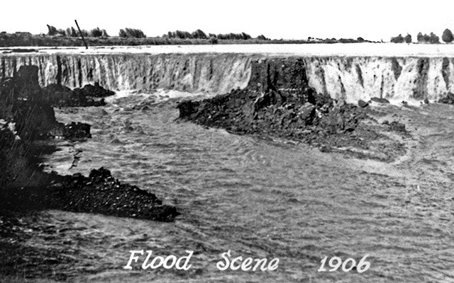
The erosive power of the floodwaters was immense. The river repeatedly scoured channels that created waterfalls, which cut back through the ground, eroding soil at a rate of about 1,200 meters per day and carving gorges 15 to 25 meters deep and more than 300 meters wide. It's estimated the flood formed more than 60 kilometers of channels and eroded 300 million to 340 million cubic meters of soil and rock, which was carried into the Salton Sea. Credit: Imperial Irrigation District.
On a scorching summer day in 1905, in the middle of a desert, the Colorado River, which had broken free from an irrigation canal and found its way to the lowest point around — the Salton Sink — swamped the Southern Pacific Railroad. Bounded by the Mojave Desert to the north and the Sonoran Desert to the south, the sink lies 70 meters below sea level at the bottom of the Salton Trough. By the time the railroad sealed the breach 18 months later, the Salton Sea stretched 58 kilometers long and 42 kilometers wide, making it California’s largest lake.
The shock of water in the parched desert recreated an old lake that had disappeared about 200 years before. The Salton Sea, past and present, owes its existence to the geological events that created the trough in which the water sits. But humans, from Native Americans centuries ago to ambitious turn-of-the-century entrepreneurs to modern-day farmers, have also shaped the desert lake, sometimes inadvertently. Just as the ancient lake disappeared, so too is the current one disappearing — slowly revealing a toxic, dusty wasteland. Restoration efforts are underway, as humans now try to save the lake they accidentally created.
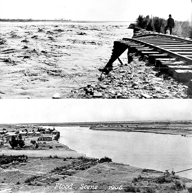
In early 1905, following torrential rains, the Colorado River broke through an irrigation canal and washed out farms, fields and roads on its way to the Salton Sink. In summer, it also washed away the Southern Pacific Railroad tracks that ran through the sink. The railroad would spend the next year and a half fighting back the river. Credit: both: Imperial Irrigation District.
The most recent predecessor to today’s Salton Sea was Lake Cahuilla, which filled the basin as recently as the 1700s. But the Salton Basin has filled, dried out and filled again many times through geologic history. “We can show that it’s been wet for 80 percent of the past 15 million years,” says Doug Barnum, a biologist at the U.S. Geological Survey’s Salton Sea Science Office in Palm Springs, Calif.
The basin lies in the Salton Trough, an active pull-apart basin that includes the Coachella and Imperial Valleys in Southern California and the western half of the Mexicali Valley and the Colorado River Delta in Mexico. The trough lies between two parallel fault zones — the San Andreas to the east and the San Jacinto to the west — which accommodate extension from the spreading East Pacific Rise.
The fate of any body of water in the trough is tied to the fickle nature of the Colorado River, which has changed course — and the location of its delta — many times. Before impoundment, the river, which drains much of the southwestern United States, was a fearsome agent of erosion. As the river meandered south, it downcut through the Colorado Plateau, scouring trillions of tons of fine silt and sand and carving the Grand Canyon in the process.
Over the next few million years, as massive sediment deposits built up at the mouth of the river, the river’s outlet and delta migrated back and forth between the Salton Trough to the north and the Gulf of California to the south. About 400 years ago, Lake Cahuilla formed when the river diverted from the gulf back into the trough.
In 1853, geologist William Blake, who’d joined an expedition to survey the West for a possible railroad route, identified evidence in the sedimentary record of an ancient lake: wave-cut benches, ancient sandy shorelines, deposits of mussel shells found high in the surrounding hills, and former high-water marks of calcium carbonate tufa. The ancient lake covered approximately three times the surface area of the present-day Salton Sea.
Blake named Lake Cahuilla after the native Cahuilla people he met there. Their ancestors, numbering perhaps 10,000, had lived around the ancient lake, which was continuously fed by the Colorado River and, at its maximum, was the largest freshwater lake in California. In the 19th century, the Cahuilla people survived in the dry, desert environment by using ditch irrigation to channel water from springs around the Imperial Valley to grow corn, barley and vegetables.
Blake saw the same potential for farming the Imperial Valley that the Cahuilla had, and suggested irrigating the region with water brought in by channels from the Colorado River. Although Blake proposed the idea in 1857, it was not until 40 years later, after multiple failed attempts, that it was successfully implemented.
Oliver Wozencraft, a physician from San Francisco who moved to the area in 1857, also identified evidence that the Colorado River had occasionally overflowed into the Salton Basin and started a campaign to irrigate the desert. In 1859, Wozencraft asked Congress to give him title to 6 million acres, including the entire Salton Basin, arguing that he needed the rights to the land in order to secure financing for the project. However, before Wozencraft gained the title, the Civil War broke out and consumed Congress’ attention.
Thirty years later, Charles Rockwood, an engineer who had worked on railroad and irrigation projects, decided the easiest way to transport the water would be to recreate the river’s ancient path. Rockwood solicited funding for the project, but it was considered too risky. In 1900, when engineer and irrigation expert George Chaffey took over Rockwood’s company, the project was finally realized.
Chaffey bought a dredger and cut a canal to divert water from the Colorado River into a natural overflow channel called the Alamo River. In June 1901, the Imperial Valley began receiving water and agriculture flourished, with early settlers and farmers buying up tracts of now irrigable land.
The irrigation system was initially successful, but as the canals silted in, new cuts in the banks had to be made farther downstream, in Mexico. In 1905, torrential rainfall swelled the river, causing it to break through the man-made irrigation canals and drain to the north, where it overwhelmed the tracks of the Southern Pacific Railroad. “In the struggle for supremacy between the Southern Pacific Railroad and the Salton Sea the waters have won,” announced an article in the Los Angeles Herald on July 26, 1905.
Although the railroad company lost the battle, it eventually won the war. The president of Southern Pacific Railroad, E. H. Harriman, sought assistance from President Theodore Roosevelt, who then asked Congress to help the railroad company staunch the floods pouring into the Salton Sea. Thousands of men were employed to force the river back into its channel. After many failed attempts, the final successful effort involved using railcars to move rocks continuously over three weeks from quarries up to 180 kilometers away, dumping the rocks into the breach until they created a dam that finally held back the river on Feb. 7, 1907. nbsp;
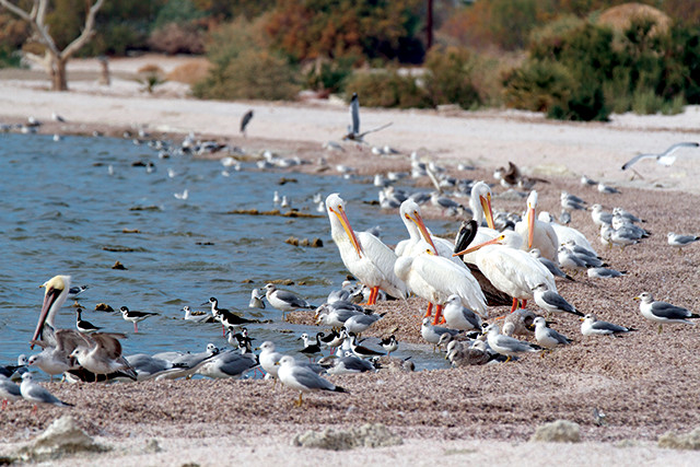
Birds migrating between Patagonia and Alaska take refuge in the Sonny Bono Salton Sea National Wildlife Refuge in the southern part of the Salton Sea. Many also reside along the lake full time. Credit: TPatel Photos, CC BY-NC-ND 2.0.
A man-made disaster may have formed the Salton Sea, but the presence of a massive lake in the middle of a desert has been a boon to fish and bird communities, the size and diversity of which have evolved over the last 100 years, often in response to the lake’s changing water quality.
Between 1905, when the lake started filling, and the early 1940s, the Salton Sea was predominantly freshwater and hosted few fish and bird populations. Over the following decades, however, cut off from freshwater inputs from the river, the water became as salty as the ocean. Marine fish species introduced to the lake in the 1960s flourished, which attracted birds migrating along the Pacific Flyway between Alaska and Patagonia.
Since then, the Salton Sea has continued to become more and more saline. While saline-tolerant tilapia have thrived, many fish have died off in this salty environment, which is also subjected to pollution and eutrophication events that sap oxygen from the water. The finger-length desert pupfish, the only fish native to the Salton Sink, is now listed as endangered by the state and federal government. The brown pelican, which heads to the Salton Sea from nesting areas in Baja California, is also listed as endangered.
To minimize disturbances to nearby crops and protect habitat for migratory birds, the Salton Sea Migratory Waterfowl Refuge (now called the Sonny Bono Salton Sea National Wildlife Refuge) was established in the southern portion of the Salton Sea in 1930. In 1954, California established the Imperial Wildlife Area.
For the past few decades, almost all of the water inputs to the Salton Sea have come from agricultural runoff, Barnum says, which has contributed to poor water quality. Water runoff from agriculture is laden with salt, excess nutrients, pesticides and fertilizers. “Everything that comes in stays here,” Barnum says. “The only thing that leaves is water during evaporation.” Furthermore, inflow from the nearby Alamo, New and Whitewater rivers is heavy with silt, agricultural runoff and other pollution. “When [the river water] comes in, it looks like chocolate milk,” Barnum says.
By 2017, irrigation flows will have diminished even further, as the 2003 Quantification Settlement Agreement, which stipulates how every drop of water from the Colorado River is spoken for, is phased in, limiting the amount of Colorado River water that goes to Imperial Valley farmers.
“As long as we have agriculture in this area, we’ll always have water going to the Salton Sea, but it won’t be the high amount of water that we’ve seen in the past,” says Jessica Lovecchio, a biologist with the Imperial Irrigation District. As the lake shrinks, 65,000 to 75,000 acres of previously submerged land will emerge and dry, possibly releasing significant amounts of dust that could pose human health risks, she says. The Imperial Irrigation District has proposed a few pilot projects, including soil tilling and enhancing native vegetation, to reduce airborne dust before it becomes a hazard, Lovecchio says.
The future of the Salton Sea remains controversial. After maintenance flows by the Imperial Irrigation District diminish beginning in 2017, the lake’s elevation is predicted to drop roughly 8 meters by 2040 (the maximum depth currently is about 16 meters). While some groups have accepted the lake’s eventual evaporation, others want to pump water from the Pacific Ocean to raise water levels, though that would further raise salinity.
Currently, the U.S. Army Corps of Engineers and the California Natural Resources Agency are finalizing a plan — called the Salton Sea Species Conservation Habitat Project — to restore the Salton Sea’s shallow water habitat, which supports fish and wildlife. Additionally, the nonprofit EcoMedia Compass has started a campaign called “SOS — Save Our Sea” to restore the Salton Sea to prevent potential severe health risks from dust and maintain wildlife habitat. Regardless of such efforts, the Salton Sea could be facing extinction once again.
© 2008-2021. All rights reserved. Any copying, redistribution or retransmission of any of the contents of this service without the expressed written permission of the American Geosciences Institute is expressly prohibited. Click here for all copyright requests.