
by Laurie J. Schmidt Monday, August 1, 2016
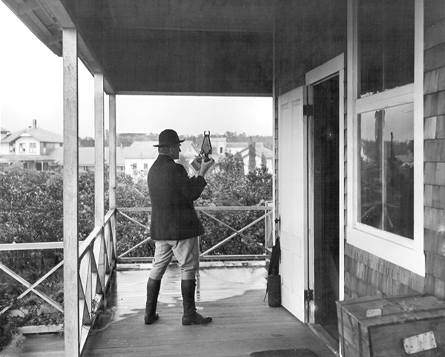
Thomas A. Jaggar Jr., seen here in 1916, prompted the establishment of the Hawaiian Volcano Observatory and served as its director from 1912 until 1940. Credit: USGS HVO.
Living on the fringe of an active volcano in Hawaii is a precarious venture. Because Hawaii’s shield volcanoes aren’t prone to explosive activity, you’re typically not threatened by violent eruptions such as would occur at Mount St. Helens, for example. On the other hand, the slow-moving, unpredictable lava flows can still overtake your home, even if it has avoided years of previous eruptions.
Fortunately, for the last 100 years, residents who live adjacent to Kilauea Volcano on the Big Island of Hawaii have had the Hawaiian Volcano Observatory (HVO) watching their backs. Perched on the rim of Kilauea’s summit caldera, HVO’s scientists monitor the volcano’s activity through aerial surveillance and on-ground fieldwork — providing eruption updates that help keep island residents and visitors out of harm’s way.
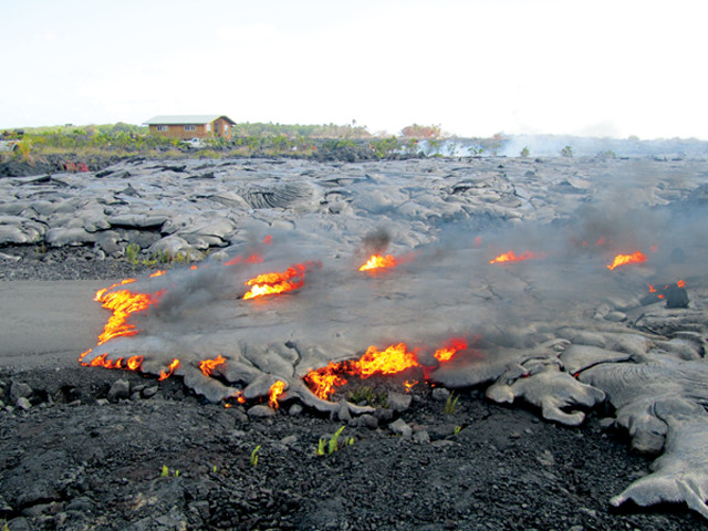
Kilauea is one of the most active volcanoes in the world. For the past 29 years, a nearly continuous eruption from the Puu O`o vent has channeled lava from the volcano’s east rift zone to the sea via lava tubes. Since the eruption began in 1983, lava has covered about 120 square kilometers near Kilauea’s east flank.
The first descriptions of eruption activity at Kilauea were recorded as early as 1823, when English missionary William Ellis wrote about his observations of the volcano’s summit region. But in 1909, a visit by Thomas A. Jaggar Jr., a geologist at MIT, sparked an interest in monitoring Kilauea — an interest that would prompt the establishment of HVO just a few years later and usher in the first comprehensive volcano monitoring program in the United States.
Jaggar wasn’t just interested in the physics of volcanoes; he was also a staunch proponent of emergency preparedness. On a quest to understand the geologic processes that led to volcano and earthquake disasters, he embarked in 1902 on an eight-year exploration of active volcanoes in places such as the Caribbean, Italy, the Aleutian Islands, and Japan. After an earthquake near Italy’s Mount Etna killed about 72,000 people in 1908, Jaggar was convinced that systematic studies of volcanic and seismic activity and their accompanying hazards must be supported.
The following year, after visiting two active volcanoes in Japan, Jaggar made a stop in Hawaii, where he gave a lecture on volcano hazards to local businessmen. After the lecture, prominent Honolulu lawyer Lorrin A. Thurston approached Jaggar about the idea of building a scientific observatory at Kilauea. To support the venture, the Hawaii Volcano Research Association (HVRA) was formed, with financial backing from Thurston and other Honolulu businessmen.
The HVRA established an observing station on the rim of Halemaumau Crater on Kilauea’s summit caldera, and by October 1910, monitoring instruments had been purchased and shipped to Hawaii. But Jaggar wasn’t able to return to Hawaii as quickly as he had hoped, so he called upon Frank Perret, an American volcanologist who was known for his studies of Italian volcanoes, to assist with the observatory in Hawaii. Perret arrived at Kilauea in July 1911 and began studying the lava lake in Halemaumau Crater, lowering sensors from cables that stretched across the crater to record lava temperatures in the lake.
On Jan. 17, 1912, Jaggar finally returned to Hawaii and began his long tenure as director of the observatory. Although the beginning of HVO wasn’t marked by an official ribbon-cutting ceremony, its founding date is usually cited as being sometime between July 2, 1911, when Perret arrived, and July 1, 1912, when Jaggar received his first paycheck.
From 1912 to 1919, HVO was managed by the HVRA with funding support from MIT. Operations were transferred to the U.S. Weather Bureau in 1919, and then to the U.S. Geological Survey (USGS) in 1924. During the Great Depression, the National Park Service took over management of the observatory, but USGS resumed administration of HVO in 1947. Jaggar served as director of HVO until he was forced to retire in 1940, after President Franklin Roosevelt had already deferred his mandatory retirement for two years. He then became a professor at the University of Hawaii.
In addition to Kilauea, HVO also monitors Hawaii’s other three active volcanoes — Mauna Loa and Hualalai on the Big Island and Haleakala on Maui — and is currently one of five volcano observatories in the United States, which together comprise the USGS Volcano Hazards Program. (The others are Alaska, California, Cascades and Yellowstone.)
When eruption activity threatens to impact human infrastructure, HVO works closely with both Hawaii Volcanoes National Park and Hawaii County Civil Defense to provide information needed to make evacuation decisions. “We try very hard to make sure everyone is well informed about what the volcano is doing,” says Mike Poland, a geophysicist at HVO since 2005.
Advancing lava has almost completely buried the town of Kalapana, seen here in 2010. Credit: M. Patrick, USGS HVO.
And Kilauea’s current eruption phase has provided ample opportunity to test this cooperation. Between 1983 and 1990, lava flows destroyed a visitor center in Hawaii Volcanoes National Park, several roads, and about 180 homes in the town of Kalapana and in the Royal Gardens subdivision, which is situated adjacent to Kilauea’s east rift zone. (The last remaining home in Royal Gardens succumbed to lava on March 5 of this year.) Between April and June 1990, advancing lava almost completely buried the town of Kalapana and covered a large section of Highway 130, which once served as a coastal entrance to the national park. HVO provided up-to-the-minute information about lava movement that aided Hawaii County Civil Defense in making decisions about evacuations and road closures.
During its first 100 years, HVO has generated a wealth of data and observations related to volcanic activity, much of which would have been impossible to collect anywhere else. In the 1950s, HVO scientist Jerry Eaton designed and installed an electronic seismic network — which dramatically improved scientists’ ability to detect and locate earthquakes — as well as a system of tiltmeters that tracked magma storage and movement. Data generated by these two innovations contributed to a greater understanding of Kilauea’s plumbing and led to the first theoretical model of how Hawaiian volcanoes worked.
According to Poland, continuous GPS networks at Kilauea have been instrumental in mapping Kilauea’s magma plumbing system and forecasting changes in eruptive activity. In 2000, the network detected a sudden movement of the south flank toward the sea that lasted about two days. “We now know the south flank experiences ‘slow earthquakes’ like those in Cascadia, where the volcano lurches seaward by about 3 to 5 centimeters over the course of one to two days,” Poland says. “If this happened all at once, it would cause about a 5.5-magnitude earthquake.”
HVO is also one of the few places where continuous gas emissions are tracked daily, which has helped scientists understand hazards related to volcanic gases. Volcanic smog (“vog”) is air pollution that results when eruptions emit sulfur dioxide and other gases; it can cause health impacts to humans such as headaches, watery eyes, breathing problems, and flu-like symptoms. Although vog usually only affects the Big Island, local wind patterns sometimes carry it to neighboring islands.
Kilauea’s continuous eruption and its relative accessibility make HVO an ideal natural laboratory for volcanologists around the world. “For the past 29 years, you can count on eruptive activity at Kilauea,” Poland says. “So for scientists who want to evaluate a hypothesis about volcanic activity or test a new monitoring technique, Kilauea is at the top of the list of places to go.”
In addition, through the Center for the Study of Active Volcanoes at the University of Hawaii in Hilo, HVO contributes to an international training program that brings volcanologists from developing countries to Hawaii. “There is a long history of scientists coming to Hawaii to learn more about volcanoes, and then taking that knowledge and applying it elsewhere,” Poland says.
Today, much of the research at HVO focuses on the summit eruption, which Poland says is unique in Kilauea’s recorded history. “It’s a long-lived lava lake that is erupting copious amounts of gas and some tephra, but very little lava,” he says. “And it’s so close to HVO that studying the eruption is relatively easy.” Poland has also been working on gravity monitoring at Kilauea. He and his colleagues are installing continuous gravimeters and recording signals that may indicate convection in the magma chamber that occurs on the scale of mere minutes. He hopes to eventually turn the process into a real-time monitoring technique that would provide information not available from other measurement methods, such as seismic observations and GPS.
HVO is celebrating its centennial with lectures and guided hikes throughout 2012, and a new illustrated publication that highlights the observatory’s history and accomplishments (available at http://pubs.usgs.gov/gip/135). To view Kilauea in real-time via USGS/HVO webcams, visit http://hvo.wr.usgs.gov/cams.
© 2008-2021. All rights reserved. Any copying, redistribution or retransmission of any of the contents of this service without the expressed written permission of the American Geosciences Institute is expressly prohibited. Click here for all copyright requests.