
by Meg Marquardt Wednesday, July 6, 2016
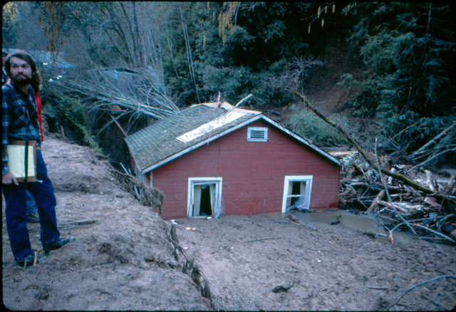
A debris flow blocked a creek in Santa Cruz County. As the water and mud were diverted, a creek bank collapsed, dropping a house into the creek. Credit: California Geological Survey.
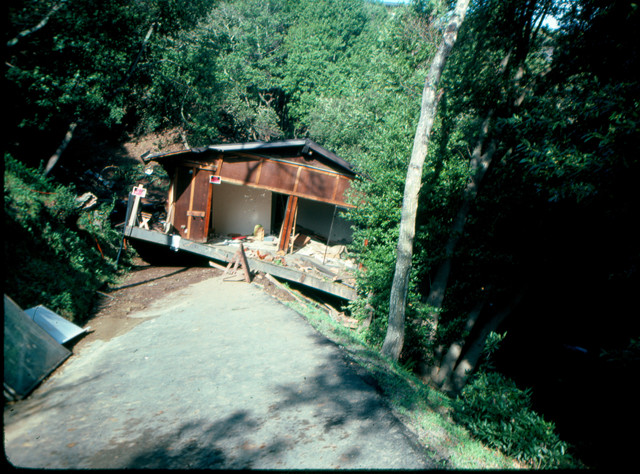
The debris flows in some regions were so fast and massive that they transported homes dozens of meters. Credit: California Geological Survey.
When a storm battered California’s San Francisco Bay Area in early January 1982, the rain was intense, but not without precedent. The region had historically endured heavy rains during the winter months, with individual storms sometimes bringing more than half the annual average rainfall in a single 36-hour span. But a collection of unique factors in 1982 created a recipe for a landslide disaster. First, two weather fronts merged, bringing copious amounts of rain to an already saturated region. Second, the rising population had resulted in a construction boom in the iconic hills of the Bay Area. During three days of relentless rain from Jan. 3–5, 1982, a record 18,000 individual landslides occurred, killing at least 25 people.
Landslides come in two basic forms: deep and shallow. Deep slides can change a face of a mountain, moving large amounts of earth and rock. They tend to be more catastrophic than shallow slides, often taking out whole hillsides. Shallow slides — also known as debris flows and mudslides — generally consist of surface sediment, topsoil and loose rock debris. They tend to leave only small scars on hillsides as they are pushed along by flooding. They occur with almost no warning. Prior to 1982, city officials considered deep slides to be the biggest threat to the Bay Area.
Landslides were not a new phenomenon for the Bay Area, which encompasses San Francisco, Oakland and San Jose, as well as many smaller cities and the surrounding rural areas, including the hills of Wine Country. With the Cascade Range to the north and the Sierra Nevada to the west, the region is a mass of hills and valleys, covering about 18,000 square kilometers. At least six different terranes were cobbled together over millions of years, including sedimentary, igneous and metamorphic rocks of varying strengths. Multiple faults run through the region as well.
Records of landslides stretch back to the mid-1800s, when the gold rush brought about the first booming settlement of the area. But it was the building boom of the 1970s that set the stage for a landslide disaster.
With a growing seaside economy and beautiful vistas, the Bay Area’s population had grown steadily since the late 1800s and skyrocketed after World War II. Between 1970 and 1980, the U.S. Census shows that population increased by 600,000 inhabitants throughout the region, bringing the total population to 5.2 million by 1980. In the same decade, an estimated 46,000 homes were built each year. As the population grew, builders had to turn away from the low slopes near the coast and start carving away whole sections of hills to meet the demand for new homes and businesses. As each year passed, landslides became more common. At first, the slides were small, but still noticeable enough for city and state officials to begin to log their occurrence.
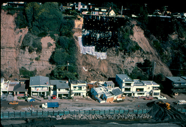
An image of a debris flow in Rio Del Mar near Santa Cruz. The entire cliff collapsed on the homes below. Credit: California Geological Survey.
The danger of landslides is always higher from October to May, when California faces the brunt of winter storms. There are two distinct types of storms during those months: long-term steady rains with lower precipitation rates, and short deluges that can drop more than 6 millimeters of rain an hour. The long-lasting systems can rain over a region for weeks on end, slowly saturating the ground. But short storms, which typically last about three days, tend to appear during otherwise abnormally dry weather. The last such storm to strike the Bay Area prior to 1982 hit on Jan. 20–21, 1967, but even though it brought more than 60 millimeters of rain, the weeks before and after were dry, minimizing potential landslide damage.
In winter of 1981–1982, however, a mix of long- and short-lived storms occurred. The Bay Area had seen steady but moderate rainfall in November and December. When heavy rains started on Jan. 3, dropping up to 20 millimeters of precipitation an hour, the ground was already saturated. The floods began, and with them, landslides.
The majority of the slides were “soil slip slides,” where only the surface of the ground moves. Case studies of the event by the U.S. Geological Survey (USGS) described slide scars about a meter deep that extended several hundred meters downhill. But even though they were shallow and short-lived, the slides gathered speed and mass quickly. The displaced dirt rose to heights of three meters and struck homes with enough force to rip them from their foundations. Some homes were moved up to 50 meters away from their original location, pushed along by slides moving up to 40 kilometers per hour.
There were larger slides as well — or perhaps several small slides triggered at the same time that combined into one large flow. For example, just after the rain stopped on Jan. 5, about 459,000 cubic meters of rock and soil slid from a mountain above the town of Love Creek, killing 10 people who were trapped in their homes.
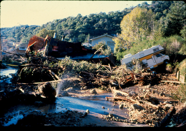
Though shallow debris flows are smaller than a deep landslide, they can still do plenty of damage to property, such as this home in San Rafael. Credit: California Geological Survey.
In the end, more than 18,000 individual slides were documented in the span of three days — and most occurred without any warning. In total, 33 people died as a result of the storm. Though reports conflict as to how many fatalities were caused directly by landslides and not by flooding or other means, a 300-page account published in 1988 by the USGS reports that 25 people died as a result of home collapses and other slide damages. The worst destruction happened in heavily populated areas, especially in the newly developed suburbs. The soil on the hills was already loose from the new construction, making the hillsides particularly susceptible to erosion and displacement. An estimated 7,800 homes and businesses were damaged, amounting to more than $66 million (in 1982 dollars) in damages.
The landslides of the 1982 storm prompted intense investigation of the continued threat to the Bay Area. The 1988 USGS report identified the merging storms and the new construction as the main culprits behind the disaster, noting that, “with respect to the specific hazard of debris flows, for example, little information of use for planning was available anywhere in the region before the storm of January 1982.”
Today, 7.15 million people live in the Bay Area in more than 2.7 million homes, some of which were built over the foundations of the homes ripped away during the 1982 landslides. Since that time, steps have been taken to prevent a landslide’s element of surprise. The Association of Bay Area Governments today works with the California Geological Survey to supply historic and real-time data to residents about the potential landslide threats. One map in particular singles out the regions that currently face the highest risk of debris flows, illustrating how much emphasis is now placed on the shallow slides that caused so much damage in 1982.
The maps can be found at http://quake.abag.ca.gov/landslides/.
© 2008-2021. All rights reserved. Any copying, redistribution or retransmission of any of the contents of this service without the expressed written permission of the American Geosciences Institute is expressly prohibited. Click here for all copyright requests.