
by Bethany Augliere Thursday, November 8, 2018
On Dec. 7, 1988, Armenia, which was then part of the Soviet Union, was struck by the strongest recorded earthquake in the Caucasus region in 1,000 years, and one of the most lethal of the 20th century. Credit: NGDC/NOAA.
Thirty years ago this month, on Dec. 7, 1988, a magnitude-6.8 earthquake shook the northern region of the then-Soviet republic of Armenia. At 11:41 a.m., the earthquake damaged nearly a third of the small country and destroyed the town of Spitak near the epicenter.
The quake, known as the Spitak earthquake, killed between 25,000 and 60,000 people, injured up to 130,000, and left more than 500,000 homeless. Two-thirds of the victims were under 18. Hospitals and schools collapsed, and electrical and water supplies were cut off. While most electrical substations were repaired within a week, electricity was not restored to many residences for months, according to a 1991 report by engineers for the Electric Power Research Institute.
It was the strongest recorded earthquake in the Caucasus region in 1,000 years, the most destructive quake in the world since the 1976 Tangshan earthquake in China, and one of the most lethal of the 20th century. Despite Cold War tensions, Soviet leader Mikhail Gorbachev, who was in the U.S. on the day of the quake visiting the United Nations and meeting with President Ronald Reagan, asked for humanitarian aid from the United States within days of the event. The U.S. — and the world — responded.
The 1988 earthquake ruptured along the western segment of the Pambak-Sevan thrust and fold belt in northern Armenia. Credit: K. Cantner, AGI.
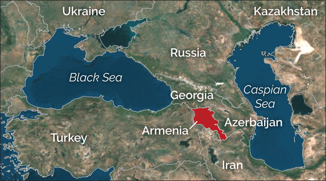
Armenia is a small country about the size of Maryland that borders Turkey to the west, Iran to the south, Azerbaijan to the east and Georgia to the north. Areas to the southwest of Armenia, such as the northeastern Mediterranean coast, Turkey and Iran, are quite seismically active: More than four quakes with magnitudes greater than six have struck Turkey in the 20th century alone.
Northern Armenia comprises a mountainous plateau interspersed with populated river valleys and is home to a portion of the Caucasus Mountains, which sit along an active seismic belt spanning from the Alps in southern Europe to the Himalayas in Asia. This mountain system began to form during the Late Triassic, largely from the tectonic collision between the Arabian Plate and the Eurasian Plate. In northern Armenia, the 600-kilometer-long Lesser Caucasus Mountains experience north-south compression as the two plates converge, giving rise to seismic active in recent times: a magnitude-5 earthquake hit Spitak in 1967, a magnitude-5.7 earthquake struck Leninakan (now Gyumri) in 1926, and a magnitude-5.3 event hit Kirovakan in 1911. But the region had no historic record of seismic events above magnitude 5.7 and thus it had received little attention in seismic hazard studies. Few seismologists thought an earthquake as powerful as the one in 1988 was possible in the region, according to a 1989 review paper published in Nature.
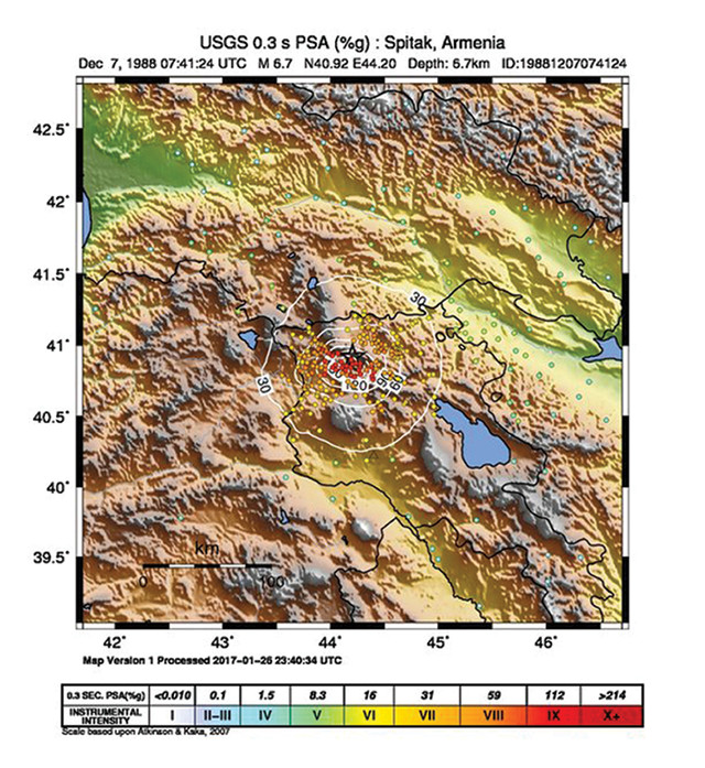
The magnitude-6.8 earthquake induced extreme ground shaking. Credit: USGS.
On Dec. 6, 1988, a magnitude-3 earthquake hit northern Armenia, though it received little attention because of the perceived lack of serious seismic risk in the area. The next day, it became obvious that this small event was a foreshock. On the morning of Dec. 7, the mainshock hit, strongly shaking the region for 30 seconds. It was followed four minutes later by a magnitude-5.9 aftershock; together these quakes caused extensive damage across a 400-square-kilometer area. The town of Spitak was demolished; the nearby towns of Kirovakan and Leninakan also experienced heavy destruction, while rumbles were felt in Azerbaijan and Georgia. Dozens more aftershocks occurred over the next several months.
Surface ruptures caused by the main shock were observed up to 13 kilometers from the epicenter, with vertical displacement averaging 1 meter but reaching as much as 1.6 meters in places.
Seismic analysis revealed a complex seismic waveform pattern “significantly more complex than those normally seen for an event of this size,” according to a 1993 study in Journal of Geophysical Research: Solid Earth. The rupture occurred between 5 and 7 kilometers deep within the Pambak-Sevan thrust and fold zone at the base of the Lesser Caucasus Mountains. It began when a reverse fault slipped, pushing one crustal block up relative to the adjacent block. A strike-slip component in the rupture meant that the blocks also moved laterally past each other, rather than just up or down. The complex quake involved two or more ruptures on different fault planes.
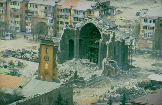
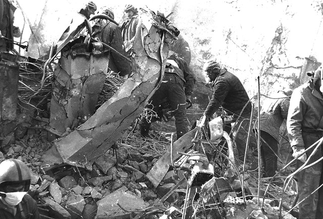
The towns near the epicenter of the earthquake experienced widespread building collapse, revealing a need for stronger building codes in the region. Credit: NGDC/NOAA.

Soviet leader Mikhail Gorbachev was attending a U.N. meeting in New York when the earthquake struck. He met with President Ronald Reagan and Vice President George H.W. Bush on Governors Island on Dec. 7, 1988. Despite Cold War tensions, Gorbachev asked for humanitarian aid, a first for the Soviet Union. Credit: National Archives.
Gorbachev was asleep in a New York hotel when the quake hit. He learned of the quake via a telegram from British Prime Minister Margaret Thatcher describing the situation, conveying sympathy and offering aid. Gorbachev cut short his trip to fly back to Moscow. “In the Armenian Republic, thousands of people have died,” Soviet Foreign Minister Eduard A. Shevardnadze said at a news conference on Dec. 8, 1988. “Despite the fact that all necessary measures are being taken … Mikhail Gorbachev believes that when a people is suffering, he has to be there and he himself has to lead the efforts.” The quake came on the heels of Gorbachev’s historic speech at the United Nations in which he called for an end to the Cold War and said that Soviet Troops would withdraw from Eastern Europe.
The world united with an outpouring of assistance for relief efforts, which was desperately needed. All the hospitals around Spitak were destroyed, and 80 percent of medical personnel were killed.
On Dec. 10, three days after the quake, three cargo planes carrying U.S. medical supplies and rescue teams, including dogs trained to sniff out survivors buried in the rubble, left Washington, D.C., and a military base in Italy, headed for the Armenian capital of Yerevan, about 100 kilometers from Spitak. This was the first time the Soviet Union had accepted help from the U.S. government since World War II.
In addition to government aid, American Armand Hammer, a philanthropist who headed Occidental Petroleum Corp., flew to Armenia on Dec. 10 with a planeload of medical supplies and a $1 million donation. The supplies included three kidney dialysis machines to help victims crushed by collapsing buildings who experienced kidney failure. “Crush syndrome,” which occurs when damaged tissues release toxins and alter blood chemistry leading to renal failure, is a common cause of death in large earthquakes. Additionally, the AmeriCares Foundation of New Canaan, Conn., sent a plane with 45 tons of medical supplies.
“Over the last two weeks, the hearts of the American people have gone out to the people of Armenia as they grappled with the earthquake disaster and its aftermath,” said President Reagan in a Dec. 22 speech in the White House. “Those of you who answered the appeal for help, who have assisted in the relief effort, and those who flew to the Soviet Union and sifted through the rubble, searching for life against all odds, carried with you a message from America. It was a message of peace.”
Relief didn’t just come from the U.S. India sent a 42-member medical team, France sent 200 rescue workers and doctors, Cuba sent blood donations and Pope John Paul II contributed $100,000. Red Cross flights brought materials from Eastern and Western Europe, and Britain sent firemen and rescue experts as well as two planes with more than 50 tons of food and medical supplies. International media reports noted criticism of the Soviet Union for its slow response and lack of preparedness. The country had no disaster contingency plans and rescue efforts were disorganized, which led to more deaths.
A lack of cranes hindered rescue efforts in the days after the Armenian earthquake. Credit: LoMit, CC BY-SA 4.0.
Despite the international relief efforts, the earthquake zone is still considered a disaster zone, and rebuilding has been slow, with recovery hampered by the collapse of the Soviet Union and subsequent war with Azerbaijan.
Even decades later, about 500 victims of the earthquake remain living in what was intended to be temporary, makeshift housing. Mental health studies have shown that many of the earthquake survivors still live with post-traumatic stress disorder. “Many of these psychological effects that were initially identified continued to persist in this population some 23 years later, affecting not only their mental health and quality of life, but in many cases their physical health as well,” said Haroutune K. Armenian, an epidemiologist at the UCLA Fielding School of Public Health, in an article in the school’s magazine in 2015.
The earthquake left deep scars on the land, as well as on the lives of survivors. Today in Armenia, Dec. 7 is a day of remembrance: Armenian Earthquake Memorial Day.
Since the Spitak earthquake, Armenia has made efforts to study and monitor the country’s seismic activity and improve emergency preparedness. The Armenian National Survey for Seismic Protection was founded in 1991, in addition to the Emergency Management Administration.
Post-earthquake studies have revealed that roughly once every 50 years, Armenia can expect an earthquake exceeding VII on the Medvedev-Sponheuer-Karnik (MSK) scale, which evaluates the severity of ground shaking, somewhat similar to the Modified Mercalli scale, and suggested that building code standards should be improved. In 1996 the seismic zoning maps were redrawn for the entire country, and in 1994, and again in 2006, the building codes were strengthened.
© 2008-2021. All rights reserved. Any copying, redistribution or retransmission of any of the contents of this service without the expressed written permission of the American Geosciences Institute is expressly prohibited. Click here for all copyright requests.