
by Allison Mills Monday, November 3, 2014
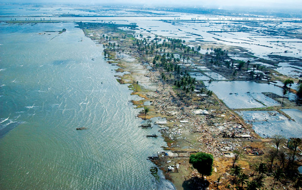
Destruction from the tsunami extended hundreds of meters inland and stretched for thousands of kilometers. Credit: Photographer's Mate 1st Class Jon Gesch, USN.
On Dec. 26, 2004, a magnitude-9.2 earthquake ruptured the seafloor off Indonesia, sending the most destructive tsunami in recorded history across the Indian Ocean. A wall of water and debris slammed the shores of South Asia; some witnesses described it as sounding like a freight train. Tourists and locals alike scrambled to safety inland and atop tall hotels, recording videos of the surging water that inundated their communities. Many were unable to reach higher ground.
This December marks the 10th anniversary of the natural disaster that killed more than 230,000 people, displaced millions and destroyed entire coastlines. Over the past decade, the Indian Ocean tsunami and its aftermath have driven researchers and governments worldwide to improve tsunami warning systems and led to the creation of the Indian Ocean Tsunami Warning and Mitigation System.
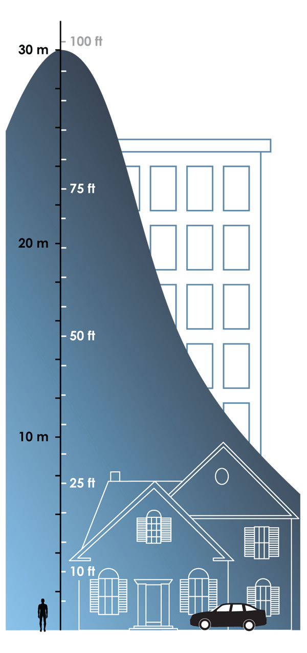
The tsunami reached heights of more than 30 meters in some places around the Indian Ocean. Witnesses say the surge of water was like a flood rather than a wave. Credit: Kathleen Cantner, AGI.
' Although 85 percent of the world’s tsunamis occur in the Pacific Ocean, they are frequent enough — and some are capable of reaching dangerous sizes — in the Indian Ocean to present a significant hazard. Earthquakes, the primary cause of tsunamis, are common throughout the countries rimming the Indian Ocean; the broad tectonic setting is primed for them as the Indian and Australian plates move north, colliding with the Eurasian Plate. The effects of extensive thrust faulting carry over to many other microplates nearby, and some local geologic settings are more active than others. ' Indonesia is one such earthquake hot spot: Magnitude-7 and above quakes occurred frequently throughout the 2000s, including three events over magnitude 8.5, for example. The chain of islands sits along the Sunda Trench, which is formed mostly by subduction of the Indian and Australian plates under the Eurasian Plate. It’s also where the Burma Microplate hits the Indian Plate to the north. Thrust-faulting here caused the December 2004 earthquake — releasing centuries of pent-up energy.
The 2004 Sumatra-Andaman quake registered at a magnitude greater than 9 (some estimates range as high as 9.3) and ruptured hundreds of kilometers along the Sunda Trench with a maximum displacement of 20 meters. Aftershocks continued through February 2005 across a zone that stretched more than 1,300 kilometers. ' The hypocenter of the earthquake was 10 kilometers below the surface and about 250 kilometers offshore of Sumatra. Witnesses in the Indonesian city of Banda Aceh, with a population of more than 200,000, reported five to six minutes of violent shaking and a few collapsed buildings during the main quake (the aftershocks caused more damage with subsequent, repeated shaking). It was the only city to report damage directly from the earthquake; most of the day’s damage would come from the tsunami waves generated by the quake.
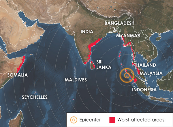
The Dec. 26, 2004, earthquake ruptured 250 kilometers offshore of Sumatra, Indonesia; tsunami waves traveled thousands of kilometers with enough power to kill hundreds of people and destroy villages as far away as the east coast of Africa. Credit: Kathleen Cantner, AGI.
The tsunami waves hit 11 countries around the Indian Ocean, stretching from Indonesia to India to Somalia. Unlike common wind- or current-driven waves, tsunamis do not travel with a rolling motion but rather with a vertical up-and-down pattern. This is because the ground motion during the earthquake displaces water, pushing the water column up and out of the way, and traveling across the ocean at speeds o’ 800 to 1,000 kilometers per hour, about the same as a commercial jet.
In deepwater, this fast-t’aveling wave is hardly noticeable; the displacement causes a small wave just a meter or so high. But this changes drastically as the tsunami approaches shore: Because the wave propagates through the whole water column, when it enters shallower water, it compresses, slows and rises up, packing its energy into less water. Sometimes, as was the case in the Indian Ocean in 2004, the pull of this rising wave is so great that the water recedes from beaches. Depending on the shore’s slope, water can be drawn out as far as a kilometer before it rushes back in.
Because tsunami waves don’t break and fold over in the ocean, like wind-driven waves, the water surges over land instead. This can be like a high tide moving in quickly but with minimal flooding, or it can be a wall of destruction that crashes inland for hundreds of meters. While dramatic, this first wall of water is not always the most dangerous. Tsunamis are usually part of a series of waves, called a tsunami wave train.
In Indonesia, Thailand, Myanmar and other countries close to the epicenter, huge waves washed over coastlines. The tsunami towered at 30 meters tall and sometimes higher, but witnesses say the waters were less wave-like and more like the surge from a powerful river or a sudden flood.
The waves swallowed boats offshore, tore up docks and washed over beaches within a minute, pushing debris farther inland into populated areas. Hotels, shops, homes and streets were flooded and ripped apart as cars, trees and parts of other buildings slammed into them. The force of the water and the debris created treacherous, fast-moving currents. These currents were just as strong when the tsunami waves retreated, drawing many people out to sea.
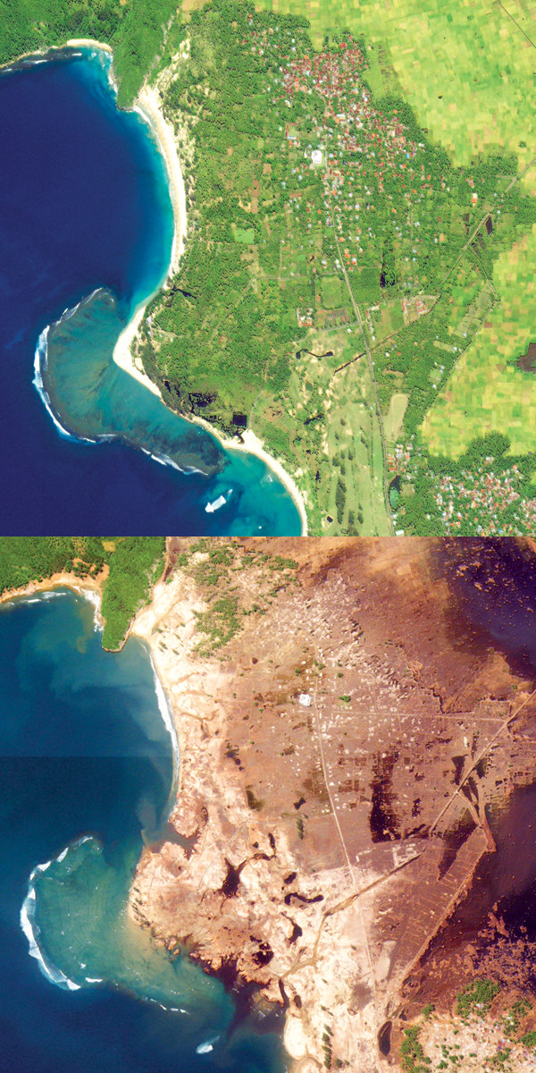
Satellite imagery shows before and after shots of coastal agriculture near Banda Aceh, Indonesia. Credit: NASA.
In low-lying coastal areas, the destruction reached hundreds of meters inland and damaged thousands of kilometers of coastline. The death toll reached nearly 230,000 lives. A number of foreign tourists were killed, especially in Thailand, although most victims were locals. Severe damage to roads and to electrical, communications and other infrastructure made providing relief to impacted areas difficult. In some places, drinking water was also contaminated, further impacting survivors. In total, about 1.7 million people were displaced and forced to live in temporary refugee camps for up to several years. Many lost their livelihoods when their shops, homes, fishing gear and other belongings were destroyed.
Coastal vegetation, coral reefs and other natural features were destroyed or damaged during the tsunami too. Animal deaths, however, were reportedly low; some researchers think this is because animals are more sensitive to their environments and can detect subtle shifts caused by earthquakes.
The earthquake and tsunami flooding also caused not-so-subtle liquefaction in some sandy areas. Liquefaction occurs when water-saturated sand is violently shaken — as it is during an earthquake — which causes the sand grains to become suspended in a quicksand-like slurry. Several engineers think liquefaction may have caused the destruction of a power plant in Indonesia as the ground was left unstable.
At the time of the Indian Ocean tsunami, the technology existed to detect such events and relay information globally within a few hours. However, the only tsunami warning system in place at the time was for the Pacific.
Tsunami warning systems are fairly simple, consisting of buoys at the ocean surface that can detect irregular wave movement and bottom sensors that can detect abrupt changes in sea level. As a tsunami passes the buoy, the signal is then relayed to satellites and transmitted across the world. The exact timing depends on how far out to sea the tsunami is generated and how fast it moves, but for basinwide tsunami threats, it’s generally a matter of minutes and at most hours between an earthquake and when a resulting tsunami hits shore, granting a window of time to get word out about the danger.
Following the tsunami in 2004, governments, researchers and activists demanded that an adequate monitoring system be put in place in the Indian Ocean. The result was an intergovernmental collaboration run through UNESCO, called the Indian Ocean Tsunami Warning and Mitigation System (IOTWS).
However, adequate technology and monitoring is only part of the solution. As earthquake geologist Kerry Sieh, director of the Earth Observatory of Singapore, said in an NPR interview from 2005, the challenge is getting the message out. Earthquake and tsunami warning systems are necessary, but they fail if there is no way to let people know about the dangers. For that reason, IOTWS runs an extensive education campaign and has helped countries develop internal tsunami warning systems.
Prior to the 2004 Indian Ocean tsunami, most beaches rimming the ocean had no signs posted about tsunami hazards or how to avoid them. And on Dec. 26, many people ran down to the beach to gawk as the sea retreated before the tsunami hit. Today, some beaches around the region do have posted signs, and IOTWS and sister programs have worked to educate people about such warning signs. The programs have shown some success. During the Samoa tsunami of 2009, advance warnings and information went out, which saved lives and prevented some unnecessary evacuations in Hawaii. However, the warning system was criticized for being too slow, and lives were still lost in Samoa.
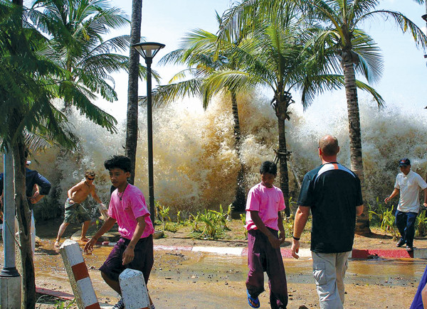
Onlookers watch as the tsunami strikes the seawall at Ao Nang, Thailand, which suffered minimal damage compared to other areas in Thailand. Credit: David Rydevik.
Even Japan, which has one of the most advanced and efficient tsunami warning systems in the world, was still overrun in March 2011 when the Tohoku tsunami struck. This tsunami is one of the best documented because of the rise of smartphones and social media.
With social media today, warnings may get out more quickly as the Pacific Tsunami Warning System uses Twitter and other outlets to spread its message. The IOTWS, following an earthquake and tsunami off Indonesia in 2012, reported better success and safety with the more widespread use of smartphones and social media. The issue of maintaining and improving warning systems remains an active part of the global discussion of tsunami hazards.
© 2008-2021. All rights reserved. Any copying, redistribution or retransmission of any of the contents of this service without the expressed written permission of the American Geosciences Institute is expressly prohibited. Click here for all copyright requests.