
by Terri Cook and Lon Abbott Thursday, January 5, 2012
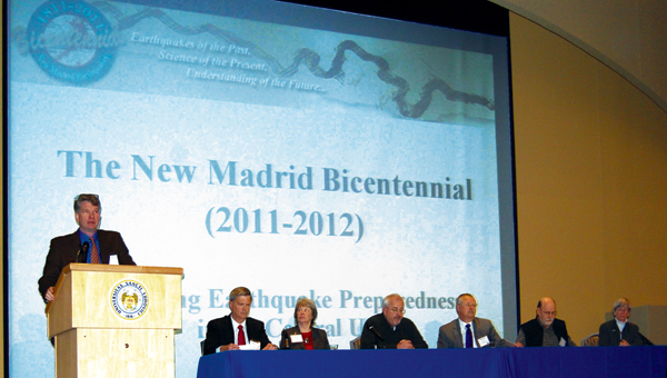
Central U.S. Earthquake Consortium (CUSEC) Executive Director Jim Wilkinson moderates a panel discussion during the 18th annual 'Earthquakes Mean Business' seminar on Feb. 11, 2011. Alisa Nave, CUSEC
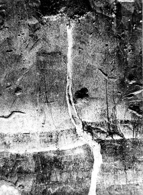
Fissures that formed during the 1811-1812 New Madrid earthquakes can be seen in this 1904 picture from Mississippi County, Mo. Fuller, M.L., U.S. Geological Survey Photographic Library
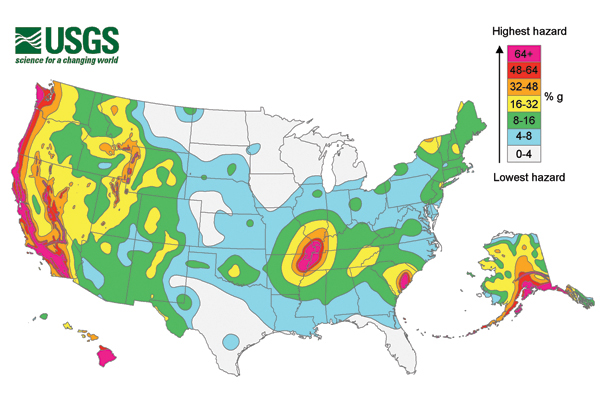
Seismic risk across the United States as estimated by the U.S. Geological Survey in 2008. Colors show the levels of estimated horizontal shaking. U.S. Geological Survey

Students demonstrate how to protect themselves during an earthquake in this 'Drop, Cover and Hold On' drill. Alisa Nave, CUSEC
This winter marks the bicentennial of a series of powerful intraplate earthquakes that occurred in the central United States over a two-month period beginning on Dec. 16, 1811. Named for New Madrid, one of the settlements on the Mississippi River, these tremors were among the largest historic earthquakes to occur east of the Rocky Mountains.
According to eyewitness reports, the earthquakes caused the ground to rise and fall, bent trees until their branches intertwined, and opened fissures in the ground. Landslides occurred along the steeper river bluffs and hillsides. Large areas of land were uplifted, while even larger areas subsided and were flooded by water, creating lakes and swamps. On the Mississippi River, huge waves overwhelmed some boats and washed others far onto shore. Channels were cut off and new ones formed. Entire islands disappeared. The area of damage extended across 600,000 square kilometers, affecting buildings as far away as Cincinnati, Ohio, St. Louis, Missouri, and parts of Kentucky and Tennessee. The area of strong shaking associated with these tremors was two to three times larger than the 1964 Alaska earthquake and 10 times larger than the better-known 1906 San Francisco event.
Two hundred years later, the New Madrid earthquakes remain enigmatic. Despite intensive study, there is still disagreement among scientists as to the earthquakes’ magnitudes, exact locations, causes and especially estimates of whether or not the New Madrid Seismic Zone still poses a substantial hazard.
Scientists rely on historical accounts and the geologic record to contextualize the 1811–1812 earthquakes. According to the U.S. Geological Survey (USGS), the first earthquake, estimated at magnitude 7.7, occurred in northeastern Arkansas just after 2 a.m. on Dec. 16, 1811. This was followed by a magnitude 7.0 aftershock later the same day. The second principal earthquake (about magnitude 7.5) occurred in Missouri on Jan. 23, and the last (about magnitude 7.7) occurred on Feb. 7 along the Reelfoot Fault in Missouri and Tennessee. Hundreds of aftershocks, with at least seven thought to exceed magnitude 6.0, were felt through mid-March.
In recent decades, researchers have been trying to learn more about the 19th-century events largely in an attempt to determine the future seismic risk in the region.
By studying seismic reflection profiles and ongoing microseismicity, researchers have found two large faults that moved in 1811–1812 lurking in the subsurface. Trenches dug across these faults and studies of sand blows — eruptions of water-saturated sand — document that the New Madrid Seismic Zone’s faults have produced clusters of major earthquakes, thought to exceed magnitude 7.0, several times in about the last 2,300 years. The last cluster comprised the events of 1811–1812. These clusters have an average recurrence interval of 500 to 600 years, suggesting that the zone releases energy at regular intervals.
Based on historical accounts of the shaking intensity, scientists have determined that two primary faults in the New Madrid Seismic Zone ruptured: the Cottonwood Grove and the Reelfoot. Today, the zone continues to experience about 200 microseismic earthquakes — events so small (typically less than magnitude 2.0) that they are not felt by people — each year. According to USGS, these ongoing earthquakes attest to high levels of stress in the region, indicating that the processes that produced large earthquakes in the past still exist.
However, how active those processes are is a matter of great debate. GPS data collected over the last 20 years reveal that present motion across the New Madrid Seismic Zone is, at most, 0.2 millimeters per year, and probably much less. Yet over the last 2,000 years the zone’s documented earthquakes have released stored energy at a rate of 1 or 2 millimeters per year — up to an order of magnitude difference. The lack of movement means that strain doesn’t appear to be accumulating on the faults, which would indicate that they are unlikely to rupture again in the future.
Based on this lack of accumulating strain, Purdue University’s Eric Calais and his colleagues, in a 2010 study in Nature, concluded that the standard seismic model does not apply to the New Madrid Fault Zone. Therefore, something other than tectonic processes must have caused the earthquakes.
A fundamental problem in determining the region’s potential seismic hazard is scientists’ lack of understanding of the physical processes controlling the recurrence of earthquakes in intraplate locations like the central United States. Geologists have a reasonably clear understanding of the mechanisms that trigger earthquakes at plate boundaries and have developed a “steady-state” model to explain them.
In this model, stress from shifting tectonic plates slowly accumulates, elastically straining the rocks. This strain can be measured with GPS technology. Each fault segment has a characteristic strength and can store energy for only so long. When the accumulated stress exceeds the strength of the rock, it ruptures, causing an earthquake. As the plates continue to move relative to one another, the cycle repeats itself, causing the same segment to fail at semi-regular time intervals with earthquakes of approximately the same magnitude. What is not clear is if this steady-state model, which forms a basis for seismic hazard estimation, also applies to intraplate faults such as those of the New Madrid Seismic Zone, where no differential plate motion exists to reapply stress after a big quake.
Calais and his colleagues, as well as several other researchers, suggest that at least in the New Madrid Seismic Zone, the steady-state model does not apply. Some have proposed that stress released by the retreat of the last ice sheet, called isostatic rebound, could have caused the earthquakes. Others have suggested that heating of the upper mantle or remote triggering by large earthquakes on other faults could be responsible for the New Madrid shaking.
Calais and his colleagues proposed yet another mechanism that is rapidly gaining traction in the scientific community that studies the New Madrid Seismic Zone: that the region’s seismicity was triggered by erosion. They modeled a scenario in which about 12 meters of soil were eroded by glacial meltwater in the Mississippi River Valley during the last glacial/interglacial transition period 16,000 to 10,000 years ago. That erosion, they found, which reduced the normal stress present in the upper crust, was enough to trigger earthquakes on pre-existing faults that lay close to failure equilibrium. This hypothesized mechanism explains both the absence of recent strain accumulation as measured by GPS as well as a four-orders-of-magnitude increase in slip rate that has been observed within the last 10,000 years. (Given that stresses induced by plate motions change on timescales of millions of years, this striking increase in slip so recently is not consistent with an underlying tectonic cause, Calais and his team reported.)
If the Calais model is correct, he and his team suggest that fault segments that have already ruptured are unlikely to fail again soon. Thus, seismic hazard in the New Madrid Seismic Zone may be minimal. Northwestern University seismologist and New Madrid expert Seth Stein goes even further. In his 2010 book, “Disaster Deferred,” he argued that the risks from the New Madrid Seismic Zone have been overestimated, resulting in a misallocation of funds for disaster preparedness and seismic research. However, not everyone agrees with this assessment. In fact, earlier this year the National Earthquake Prediction Evaluation Council — an advisory group to the Director of the USGS that was created by 1980 legislation reauthorizing the National Earthquake Hazards Reduction Program — convened an independent panel of experts to review the level of risk in the New Madrid Seismic Zone. The panel concluded that the zone is still at significant risk for damaging earthquakes, and that it is unlikely the processes driving earthquakes there have ceased.
Underscoring the controversy is a series of national seismic hazard maps generated by USGS. These maps, which are used to set everything from building codes to insurance rates, show the New Madrid Seismic Zone as having the highest potential hazard for severe ground shaking, on par with the tectonically hyperactive West Coast, including the Cascadia Subduction Zone and the San Andreas Fault Zone. In 2006, the USGS convened a workshop of experts to reassess this risk. The panel acknowledged that recent GPS data showed little to no ground motion at the surface, but the experts did not find sufficient evidence to lower the region’s rating given the historic seismicity, the evidence of violent ground shaking in the geological record, and the ongoing microseismicity.
Interestingly, even if Calais’ model is correct and the New Madrid region is not tectonically active, the model also implies that subtle stress changes, such as those caused by modest amounts of sediment removal, may be enough to trigger the failure of other faults in the American midcontinent that have not yet ruptured. So in this way, it’s possible that the seismic hazard is actually underestimated, at least according to Calais and co-authors. Scientists know that a rupture on one fault can increase stress on nearby faults, thus elevating the seismic risk in a broader area. The Calais model amplifies this longstanding concern about inherited seismic risk on intraplate faults by adding additional triggering mechanisms, such as modest erosion thousands of years ago, that subtly alter the local stress field.
The biggest concern raised by Calais’ non-steady-state model is how to determine which locations east of the Rockies are at elevated seismic risk. Scientists don’t currently possess the tools necessary to determine which pre-existing fault segments are close to failure, and whether or not recent, subtle changes in their stress state (triggered by events like recent post-glacial erosion, sea-level change, and the like) will tip them past that equilibrium toward rupture.
To answer such questions, researchers will continue their ongoing GPS and seismologic studies. One focus of that research will be to analyze whether their data support the new Calais model.
Regardless of the ongoing controversy, the bicentennial of the New Madrid quakes offers a teachable moment: the chance to remind people everywhere how to prepare for and react to earthquakes. On Feb. 7, 2012, thousands of people across eight states will participate in the “2012 Great Central U.S. ShakeOut,” where, like its California counterpart, citizens participate in “Drop, Cover and Hold On” drills (see videos here) to reduce injury and protect lives during earthquakes.
Knowing what to do in case of an earthquake is important no matter where you live. People along the U.S. East Coast were reminded of this in August, when a magnitude-5.8 earthquake struck central Virginia — an area listed as a low seismic risk but that has experienced a number of small-to-moderate-sized earthquakes in the last couple hundred years. Furthermore, previous intraplate earthquakes, including ones in India, China and Australia, have proven dangerous and damaging, particularly because they occurred in areas not considered to be a strong risk.
The causes of such damaging intraplate quakes remain enigmatic. Because the New Madrid quakes are probably the most thoroughly studied intraplate quakes ever, they provide a fertile testing ground for new research techniques and the examination of new theories regarding the causes of such seismic events. For that reason, continuing research on the New Madrid events will likely play an important role in enhancing our understanding of these hazardous and seemingly random earth movements.
© 2008-2021. All rights reserved. Any copying, redistribution or retransmission of any of the contents of this service without the expressed written permission of the American Geosciences Institute is expressly prohibited. Click here for all copyright requests.