
by Nate Burgess Friday, November 20, 2015
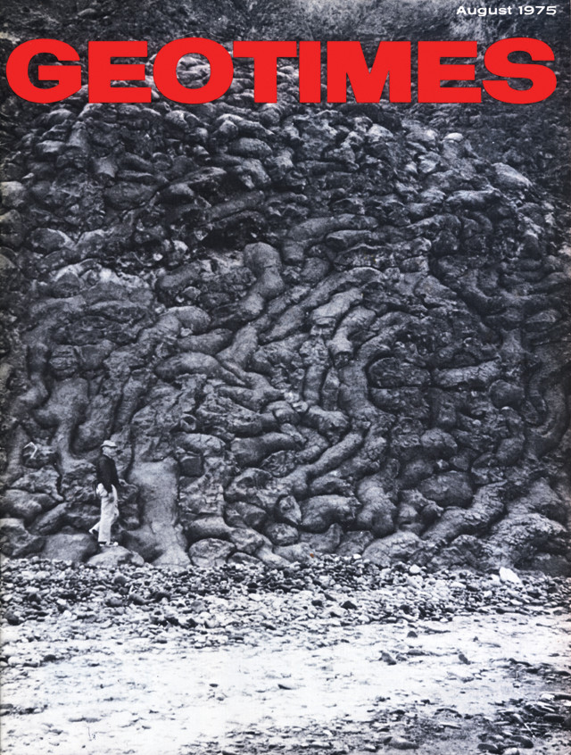
The pillow lavas pictured here on the cover of the August 1975 issue of Geotimes magazine were later named the Geotimes unit after the magazine. Credit: AGI.
In August 1975, an intriguing rock formation in Oman appeared on the cover of Geotimes magazine, EARTH magazine’s predecessor. This pillow lava — a type of rock that forms when hot molten basalt flows into water, such as happens in Hawaii, or erupts underwater — is one of the lowermost units of the now-famous Semail ophiolite sequence. Ophiolites, pieces of ancient oceanic crust and upper mantle later uplifted and exposed on land, were a hot geological topic in the 1970s, because they helped illuminate the process of seafloor spreading, a key puzzle piece supporting the then-revolutionary theories of continental drift and plate tectonics.
Several years later, in the winter of 1978-1979, a geologist named Tony Alabaster was studying the ophiolite sequence in Oman for his dissertation. He named the unusual rock formation at the bottom of the sequence the “Geotimes unit” — likely the only rock formation named after a magazine. Today, Alabaster is associate dean of resources, research and external engagement in the Faculty of Applied Sciences at the University of Sunderland in England. EARTH’s Nate Burgess talked with Alabaster about the events that transpired 35 years ago, how he gave the unit its name and what those rocks have taught us about the locations where ocean crust is generated.
NB: What got you interested in ophiolites?
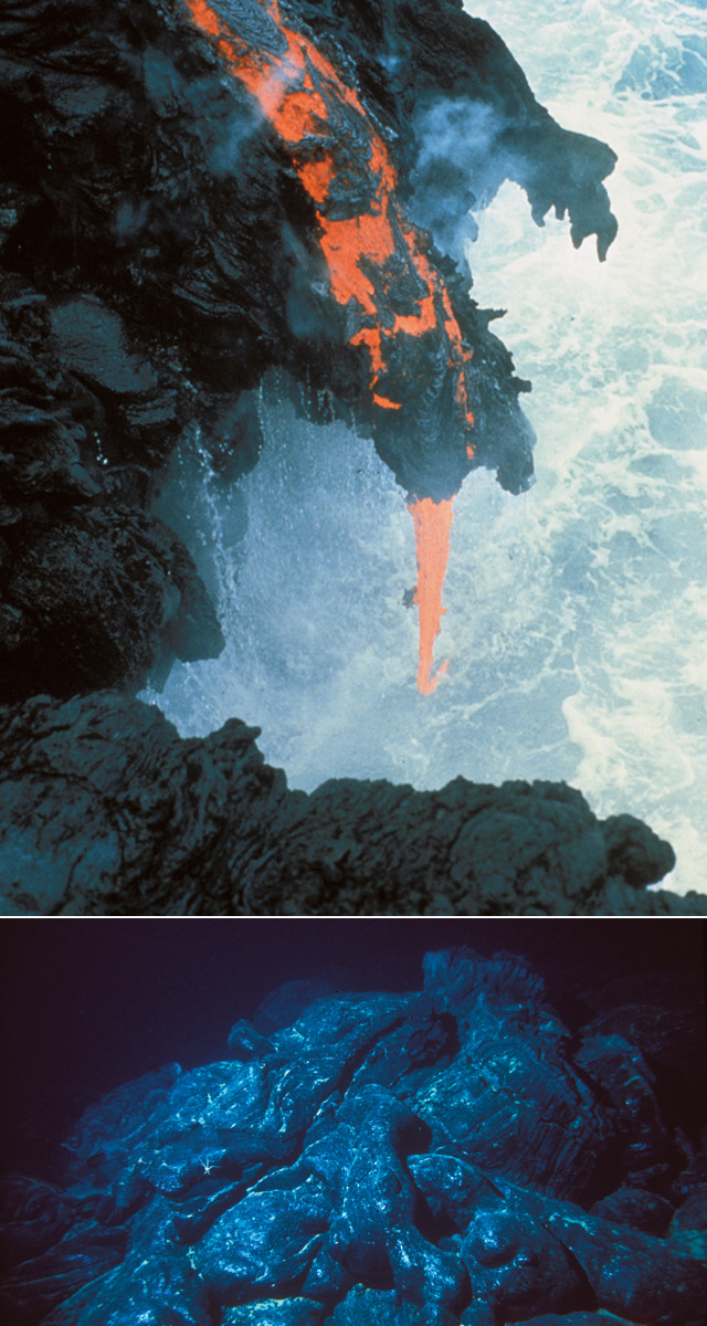
Pillow lavas such as those found in the Geotimes unit form when molten basalt flows into water — either at an underwater vent (bottom) or when a lava flow enters the ocean (top). Credit: top: R.L Christiansen, U.S. Geological Survey Hawaii Volcanoes Observatory; bottom: Image courtesy of Submarine Ring of Fire 2002 Exploration, NOAA-OE.
TA: Thirty-five years ago, life in the earth sciences world was very different. The sorts of breakthroughs in plate tectonics and continental drift that were revolutionary at that time are just taken as commonplace these days.
If you go back to the mid-‘70s and the decade before, in terms of global earth sciences, there was a lot of investment into understanding what was happening on the ocean floor. You can understand the difficulty of doing this remotely. So, if you were able to find equivalents to ocean crust on land, they would give you much greater accessibility. You would see [the rocks] in three dimensions directly. And those pieces of oceanic crust that are now on land are called ophiolites.
It was only in 1972, at the Geological Society of America’s Penrose Ophiolite Symposium, that the first formal definition of an ophiolite was accepted. At that time, there were a number of examples known around the world. There was the Trodos Massif in Cyprus. There was a less-exposed one in Newfoundland. But the general consensus worldwide was that the best-preserved, the best-exposed and the least-deformed ophiolite was the one in Oman — the northern Oman ophiolite complex.
And that attracted a whole range of international earth scientists to Oman. In the early days there were two key players: One was Professor Ian Gass, who was a member of the Royal Society and head of earth sciences at Open University in England, and the other was the U. S. Geological Survey. Once I finished my undergraduate degree, I went on to do a Ph.D. with Ian Gass that focused on this Oman ophiolite complex.
NB: What was your role in the project?
TA: It had been known for thousands of years — back to the days of the Phoenicians [from roughly 2500 B.C. to 330 B.C.] — that these ophiolite complexes contained copper deposits, called massive sulfide ore deposits. In the area of northern Oman, around Lasail, there was very strong archaeological evidence of ancient copper mining from back in the Phoenician days. Subsequent modern geophysical explorations in the 1960s and 1970s showed that there was quite a substantial copper deposit there [in the pillow lavas].
My role was to look at these copper deposits and try to understand just how they formed. If we understood how they formed on land, maybe there was a possibility of finding such copper deposits on the ocean floor. And to understand how that particular copper deposit formed, we needed to understand the volcanic stratigraphy [of the ophiolite complex].
NB: Why did you need to understand the volcanic stratigraphy? What did you learn from it?
TA: As we began our research, there was already a clear understanding that ophiolites represented ancient bits of oceanic crust that are now on land. But as more and more geochemical data were amassed [on the Geotimes unit], what also became clear was that these particular ancient bits of oceanic crust came from very specific parts of the ocean. The Geotimes unit didn’t come from oceanic trenches like the Mid-Atlantic Ridge; it came from a marginal basin, a piece of oceanic crust that formed just behind island swarms off the coast of major landmasses.
NB: How did the 1975 cover of Geotimes inspire the name of this rock? And how did your colleagues react to this name?
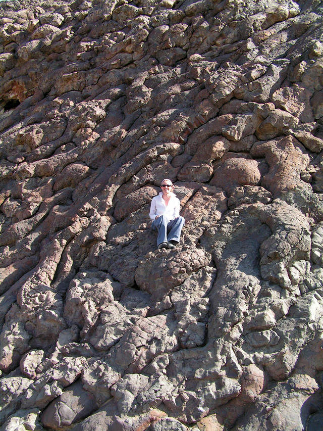
Geologist Jill VanTongeren — a graduate student at Columbia University in New York City — at the Geotimes unit in Oman. Credit: Jill VanTongeren.
TA: Wherever you looked, particularly around this Lasail area of Oman, the lowermost part of the volcanic stratigraphy was this very elongated set of pillow lavas — reddish brown, very, very distinctive. The rock in the photo was along the main Wadi Jizzi road. That photo was taken by Edgar Bailey [from USGS].
As you were heading west along that road, you would get out of your car and it was right there on the left-hand side. It became a very famous stopping-off point for earth scientists who went to Oman and were interested in ophiolites. They would go and see this classic example of pillow lavas, which in those days was quite a new phenomenon.
In the field you don’t know what the chemical characteristics [of the rocks] are. You don’t want to name them by a visual description, but by some obvious characteristic. But this example was already known worldwide, because it appeared on the cover of Geotimes in 1975. Wherever one looked, that photograph on the cover of Geotimes was the “type locality.” There was no better exposure of that type of pillow lava. So, if we were looking for a generic name for the rock formation, naming it Geotimes just seemed like the obvious thing to do. It seems strange to me now that you ask, “What was the reaction of your colleagues?” because the answer was “none.” It was just obvious!
Above that particular Geotimes unit, there was another distinctive pillow lava group, and because the type locality of that was in the Lasail area, we named that the Lasail unit. The next volcanic layer that was distinctive was in a geographic structure called an alley, so we named that the Alley unit. Above that was a fourth one, but there was no type locality, because it occurred so sporadically. So we named that based on a very specific visual thing: It contained a very large number of clinopyroxine crystals, and therefore we named that the Clinopyroxine unit. And then the fifth and final unit we called the Salahi, after another place in northern Oman. So the entire volcanic stratigraphy of this ophiolite complex, except for one, was named for type localities.
NB: When did the naming take place?
TA: I was there studying that ophiolite as part of a much bigger northern Oman ophiolite research group that was based at the Open University in England. We would fly out to Oman — as the USGS would — during winter, as it was too hot to work in the summertime. We’d work for four or five months and bring samples back to the lab. My actual Ph.D. field seasons in Oman were over the winter months of November 1978 to March 1979 and again over those same months 1979-1980. [The naming] would have been during that first field season, but I can’t recall a precise month.
© 2008-2021. All rights reserved. Any copying, redistribution or retransmission of any of the contents of this service without the expressed written permission of the American Geosciences Institute is expressly prohibited. Click here for all copyright requests.