
by Laurie J. Schmidt Wednesday, July 6, 2016
Antone Correa Aguiar, a railroad employee, is seen in the midst of floating debris just after cutting the cable to free the ship Brigham Victory during the April 1, 1946, tsunami. The ship was loaded with explosives; Aguiar freed it from the dock and it floated safely away. Aguiar's body was recovered later at Reed's Bay in Hilo. Credit: Pacifi c Tsunami Museum, Rebecca Lyman Enskine Collection.
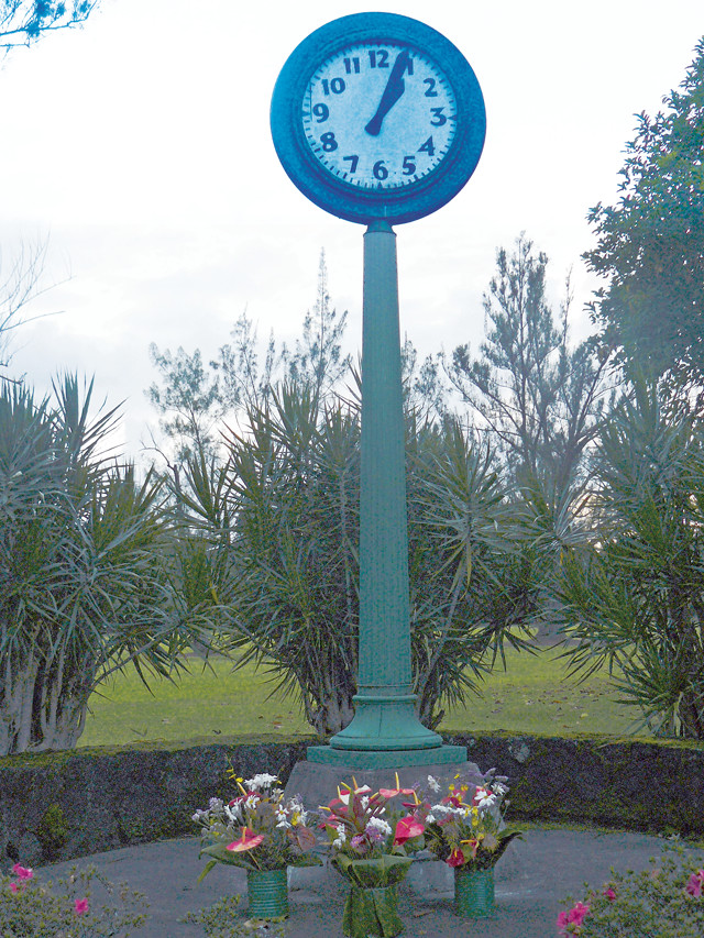
This clock, once a centerpiece of a primarily Japanese community built on a low peninsula in Hilo Bay, now stands as a monument to the 61 people who died on May 23, 1960, when a tsunami struck at 1:04 a.m. Credit: ©Denys, Creative Commons Attribution 3.0 Unported.
On the morning of April 1, 1946, children were on their way to school in the small peninsula community of Laupahoehoe on the island of Hawaii (the Big Island). Curious about the fish that were flopping around in the sand on the beach, the students were too busy to notice the ocean sucking all the water out of the bay. Minutes later, a large wave — about 15 meters high — struck the peninsula and swept 16 children and five teachers out to sea.
Masuo Kino, an 11th grader at Laupahoehoe School, survived the tsunami. “The wave flipped me over and carried me toward the lava rock wall that rimmed the school,” he said in an interview documented at the University of Hawaii’s Center for Oral History. Kino thought the wave would throw him headfirst into the rock wall, but the wall crumbled before he reached it. He was tumbled and tossed around with the debris and rock wall fragments — but he lived.
About five hours earlier, a magnitude-8.1 earthquake had occurred in the Aleutian Trench, about 145 kilometers south of Unimak Island in Alaska’s Aleutian chain. Extending about 3,400 kilometers from the Gulf of Alaska to the Kamchatka Peninsula, the Aleutian Trench is a convergent plate boundary, where the Pacific Plate is being subducted under the North American Plate. The quake uplifted a large section of seafloor, triggering a large tsunami that rippled through the Aleutian Islands and then traveled across the Pacific Ocean.
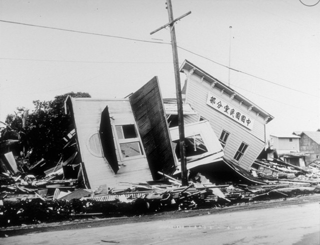
Just 48 minutes after the quake struck, a 30-meter wave crushed the Scotch Cap Lighthouse on Unimak, killing all five lighthouse keepers. The waves then traveled south to the Hawaiian Islands at an average speed of about 790 kilometers per hour. About five hours after the earthquake, the tsunami reached the Big Island of Hawaii, where it raced up Hilo Bay and pounded the city of Hilo on the island’s windward side. Several large waves devastated the coastal area and destroyed Hilo’s entire downtown waterfront area. Wave heights reached as high as two- and three-story buildings, and in some places the tsunami waves inundated areas almost half a kilometer inland. Those who didn’t escape by running upslope or climbing trees were carried away by the waves or buried in debris. The tsunami killed 159 people and caused $26 million in damage (1946 dollars) throughout the state of Hawaii. Hilo’s downtown was rebuilt.
In 1946, there was no comprehensive system of tsunami warning sirens as there is throughout the islands today. In addition, tsunami awareness education was practically nonexistent. Most residents did not recognize that receding ocean water signaled an incoming tsunami wave, and they did not know that a series of larger waves would follow the first one, or even that they should move to higher ground.
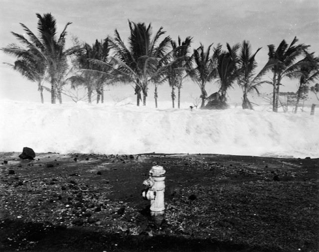
A view of the 1946 tsunami wave coming in to Keaukaha. Credit: Pacific Tsunami Museum, Jeanne Johnston Collection.
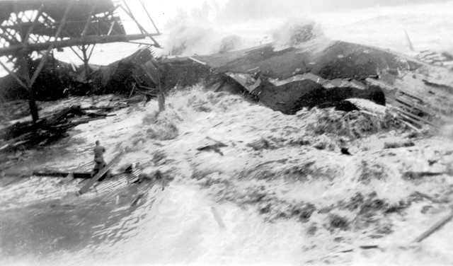
Wreckage of a political party clubhouse on Kamehameha Avenue that was destroyed by the 1946 tsunami. Credit: NOAA/U.S. Army Corps of Engineers.
As a result of the 1946 tsunami, the U.S. Coast and Geodetic Survey (C&GS) — a predecessor of NOAA — established the first tsunami “warning system” in 1949. Commander Charles K. Green, an officer in the C&GS, began looking at tidal records from the 1946 tsunami and calculated probable travel times required for the waves to reach various locations in the Pacific. He then compared his theoretical times to the actual travel times indicated by the tidal records. He also observed that tidal records from the tsunami always showed a small run-up of the water level, followed by a large withdrawal, over intervals of about 10 to 20 minutes. Based on this information, Green designed a tsunami detection system that would filter out other fluctuations in water levels (such as wind waves) and would trigger an alarm when the conditions indicated a tsunami wave.
Green’s invention was included in the new “Seismic Sea Wave Warning System,” along with seismograph stations for rapid earthquake detection, a network of tidal gauges throughout the Pacific Ocean, an improved sea wave travel-time chart, and a communications system that used civil and military emergency capacities.
This warning system was tested four times over the next 15 years, when tsunamis struck in 1952, 1957, 1960 and 1964. In each case, the system accurately predicted the wave arrival times in Hawaii. The 1960 tsunami, triggered by the largest earthquake ever measured, a magnitude-9.5 event near Chile, again devastated Hilo, wiping out waterfront stores, restaurants and homes, and killed 61 people throughout Hawaii. Warning sirens began sounding in Hilo almost four hours before the tsunami reached Hawaii, prompting many residents in low-lying areas to evacuate. But after the first wave arrived, which was only a few feet high, many people mistakenly believed that the danger had passed, and they returned to Hilo before the largest wave struck. Others simply did not heed the warnings and remained in low-lying areas.
In the aftermath of the 1960 tsunami, Pacific nations decided to coordinate their efforts to prevent significant loss of life due to tsunamis in the Pacific Basin. So, in 1968 the United States offered property at Ewa Beach on the island of Oahu as operational headquarters for what would become the Pacific Tsunami Warning Center (PTWC).
Today, the PTWC issues warnings for trans-ocean tsunamis to almost all Pacific Rim countries and most Pacific island states. After the 2004 Indian Ocean tsunami, the center assumed responsibility for additional areas, including the Indian Ocean and Caribbean Sea. It also issued tsunami warnings for Alaska until 1967, when the West Coast and Alaska Tsunami Warning Center was established. In 1975, after an earthquake struck the Kalapana area of the Big Island, the PTWC began providing official tsunami warnings for local earthquakes to the state of Hawaii.
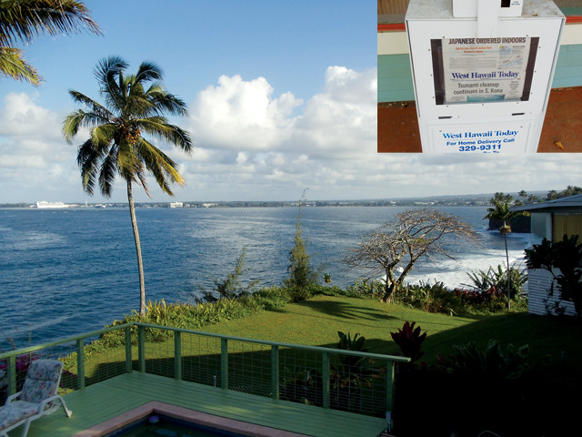
In March 2011, after the magnitude-9.0 Tohoku earthquake in Japan, much of low-lying Hilo was evacuated as a precaution. The image at left was taken the day before the tsunami from a higher area where residents did not have to evacuate. Below: Newspaper in Hawaii from four days after the March 2011 tsunami. Credit: Both: ©Megan Sever.
To determine when a tsunami has formed, the PTWC uses both seismic and oceanographic data. Based on the data received, the PTWC forecasts the most likely scenario and issues bulletins. An Information Bulletin informs the public that a potential tsunami threat exists, such as when an earthquake has occurred. The next level is a Tsunami Watch, which alerts citizens that the earthquake very likely generated a tsunami and that they should prepare to evacuate, depending on their location. Once officials are certain that a tsunami is imminent, a Tsunami Warning is issued. Tsunami Warnings include approximate wave arrival times for various locations across the Pacific, based on Tsunami Travel Time maps. The public can receive PTWC bulletins and warnings by subscribing to RSS feeds or email alerts.
More than 100 tsunamis have been recorded in Hawaii since the early 1800s, 16 of which caused significant damage. Hawaii has had two “close calls” with tsunamis in just the past two years. On Feb. 27, 2010, a magnitude-8.8 earthquake off the coast of Chile triggered a tsunami that arrived in Hawaii about 15 hours later. The PTWC issued a high-level Tsunami Warning, which gave the state more than five hours to prepare. Hawaii State Civil Defense ordered 40,000 to 50,000 people to evacuate flood-prone areas on the Big Island, including Hilo. Emergency workers knocked on neighborhood doors to urge people to evacuate, and homeless people were removed from dangerous areas. Just hours after sirens began sounding, the streets of downtown Hilo were empty — a stark contrast to the situation in 1946. The tsunami waves were smaller than expected, and PTWC scientist Gerard Fryer was widely quoted as saying that Hawaii had “dodged a bullet.”
A year later, on March 11, 2011, the magnitude-9.0 Tohoku earthquake triggered a tsunami that devastated Japan and sent waves traveling across the Pacific toward Hawaii. Low-lying areas of Hilo and other places on the Big Island were evacuated, along with low-lying areas on other islands. Water flooded roads and hotel lobbies, and severely damaged parts of Kona on the opposite side of the Big Island from Hilo. On Maui, 2-meter waves flooded low-lying areas, and boats were damaged at the island’s three major harbors. Hilo was largely spared. Again, the PTWC warnings provided citizens and state emergency officials with significant lead time prior to the tsunami’s arrival. Hawaii Gov. Neil Abercrombie said that Hawaii was “fortunate beyond words.”
Despite the fact that the state was spared any major damage or loss of life in 2010 and 2011, residents of Hawaii — and particularly Hilo — know better than to let their guard down, based on past experience. The islands are vulnerable to tsunamis generated by earthquakes not just on their own soil, but also from around the entire Pacific Ring.
© 2008-2021. All rights reserved. Any copying, redistribution or retransmission of any of the contents of this service without the expressed written permission of the American Geosciences Institute is expressly prohibited. Click here for all copyright requests.