
by David B. Williams Monday, September 28, 2015
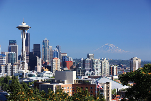
In 1992, researchers confirmed the existence of the Seattle Fault that runs through Seattle, Wash. They also confirmed several other faults that run beneath the city. Credit: ©iStockphoto.com/Jeremy Edwards.
Since the early 1900s, scientists, boaters and residents have known that a ghostly, submerged forest of dead trees lurked just below the surface of Lake Washington, on Seattle’s eastern edge. The trees were mostly too deep to bother anyone until the Lake Washington Ship Canal opened in 1916, connecting the lake and Puget Sound and dropping the level of the lake three meters. Then the dead trees — many of which were still upright — became hazardous to boaters. In response, the U.S. Coast and Geodetic Survey and U.S. Army Corps of Engineers blasted and chained down 186 trees in one submerged forest. Forty years later, when a diver visited a different underwater forest in 28 meters of water, he found himself in a dense grove of dead trees — predominately Douglas fir — the largest of which had a circumference of 9 meters.
No one knew how the trees came to be there or when they were submerged. That is, until 1992, when five research papers appeared in the Dec. 4 issue of Science. The research described the evidence for a massive earthquake about 1,100 years ago that ripped across a fault beneath what is now Seattle. In one spot, ground uplift was seven meters. In another location was evidence for a tsunami. And those submerged trees? They had been deposited in the lake via three tremendous landslides that carried the trees into the lake’s depths. A commentary accompanying the articles called the evidence for the so-called Seattle Fault “as complete a case as has ever been achieved by paleoseismology.”
A picture of the Seattle Fault actually began to emerge to geologists in 1965; they just didn’t fully realize it. The first person to propose that Seattle was underlain by some sort of fault system was University of Puget Sound geophysicist Zdenko Frankenberger Danes, who enlisted the aid of high school students to help him get a grasp on the area’s subsurface. They helped him as part of a grant focused on introducing kids to the natural sciences by having them work on a real science project.
For the project, Danes gave the students a gravimeter, an instrument that detects the subtle difference in gravitational pull between a dense rock, such as basalt, and a low-density one, such as sandstone, thus providing insights into subsurface geology. Working their way north from the university in Tacoma, the students initially found a gravity low, which changed to a gravity high just south of Bremerton before dropping abruptly again in Seattle. These gravity anomalies indicated significant variations in the rock underlying the area, generally cause for geologists to suspect that something is up. Or down.
In a paper in the Journal of Geophysical Research in 1965, Danes and his nine high school co-authors hypothesized that several active faults crisscrossed the Puget Sound lowlands and had ratcheted the subsurface rocks out of their original positions. “Danes’ notion that the very steep gravity gradient in the Seattle area resulted from faulting was very insightful,” according to Sam Johnson, a geologist at the U.S. Geological Survey (USGS) whose research has helped refine Danes’ work.
Little work was done to follow up on Danes’ proposed faults until the late 1980s when USGS geologist Robert Bucknam began to examine an anomalous marine terrace on the southeast edge of Bainbridge Island, 11 kilometers west of downtown Seattle in Puget Sound. Known as Restoration Point, the wave-cut platform consists of flat sandstone atop steeply dipping beds of older siltstone. In the lead 1992 Science paper, Bucknam and colleagues concluded that the lack of intermediate shoreline features, such as erosional scarps or gravel bars, indicated a rapid, seven-meter uplift of the island. They proposed that a massive earthquake raised the platform, and that, based on radiocarbon dates from humus and detrital charcoal atop the platform, this earthquake occurred between 500 and 1,700 years ago.
The four other papers in Science relied on more circumstantial evidence, including data from 11 large rock avalanches in the Olympic Mountains, about 75 kilometers west of Seattle. Five of the slides had blocked streams, creating lakes that submerged trees. Snags, or standing dead trees, collected from three of the lakes — Jefferson, Lower Dry Bed and Spider — indicated an earthquake occurred between 1,000 and 1,300 years ago.
Additional evidence was found in Lake Washington where multiple turbidity flows had deposited a layer of fine sediment containing organic matter, which dated to a mean age of 1,117 years before present, plus or minus 142 years. Geologists concluded that a single, large earthquake triggered the landslides. Douglas firs pulled up from the submerged forests in 1990 also dated to between 1,000 and 1,300 years ago, and further analysis of the trees’ annual growth rings indicated that the firs all died in the same year and season. (The salvage logger who helped the geologists bring up the trees from the murky lake bottom was later convicted of illegally harvesting trees from the same underwater groves. He was sentenced to a jail term of three and a half years.)
Next, scientists compared their tree ring data with a Douglas fir excavated in February 1992 from a trench at West Point, Seattle’s westernmost point, by USGS geologist Brian Atwater. The log was found in a layer of sand 4 to 6 centimeters deep that was deposited above toppled, flattened bulrush stems — evidence of a large inundation of a now-submerged tidal marsh. Atwater concluded that a rupture on the Seattle Fault had dropped West Point one meter into the sea, creating a tsunami that surged across Puget Sound. As the wave spread across what was then a tidal marsh at West Point, it deposited the Douglas fir log along with a sheet of sand.
Radiocarbon dating initially put the tree’s death at between 850 and 1,350 years ago, and comparison to the submerged trees in Lake Washington suggested that they all had died in the same season of the same year, most likely about 1,100 years ago. Archaeologists later found evidence of a 4,000-year-history of human habitation at West Point, meaning the earthquake and tsunami likely had witnesses, and perhaps victims.
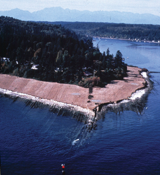
This wave-cut platform, known as Restoration Point, consists of flat sandstone atop steeply dipping beds of older siltstone. The lack of intermediate shoreline features, such as erosional scarps or gravel bars, indicates a rapid, seven-meter uplift of the island from an old earthquake. Credit: Bob Bucknam, courtesy of Brian Sherrod.
Interpreting the accumulated evidence, researchers proposed that a 40-kilometer-long single fault runs east-west from the eastern edge of Bainbridge Island through the southern end of downtown Seattle, continuing east beneath Lake Washington and Lake Sammamish. The last rupture, they wrote, was probably about a magnitude-7 quake.
In the 20 years since the papers appeared in Science, geologists have learned quite a bit more about what underlies this region. As tectonic plate movements push the Sierra Nevada Mountain block northwest at 10 to 12 millimeters per year, the block butts into another block of hard rock, encompassing the Coast Range of Oregon, which in turn rotates slightly to the north and pushes northward into Washington. But western Washington cannot budge much because the North American block to the east and north is essentially fixed. In essence, Seattle is being squeezed between a rock and a hard place.
This region of compression forms the Seattle Fault Zone, now thought to consist of at least three or four separate faults or splays all cutting east-west across the Seattle area. Only the northern splay shows signs of recent movement. In the past 10 million to 15 million years, an estimated 10 kilometers of vertical movement has occurred between the uplifted and down-dropped sides of the fault.
Geologists have also realized that the Seattle Fault is not alone; they have found evidence for a dozen or more similar faults in the area that may be connected. These connections may extend across the Cascade Range into eastern Washington and the Yakima fold and thrust belt.
“nbsp; "
“No one is saying that there is a single fault that runs from Vancouver to Yakima [almost 300 kilometers], but we do think that one fault could jump strands and trigger others,” says USGS geologist Brian Sherrod. Sherrod and his co-authors recently wrote in the Journal of Geophysical Research– Solid Earth that “the throughgoing faults proposed here would pose significantly increased seismic hazards if they should prove to be active along their entire margin.”
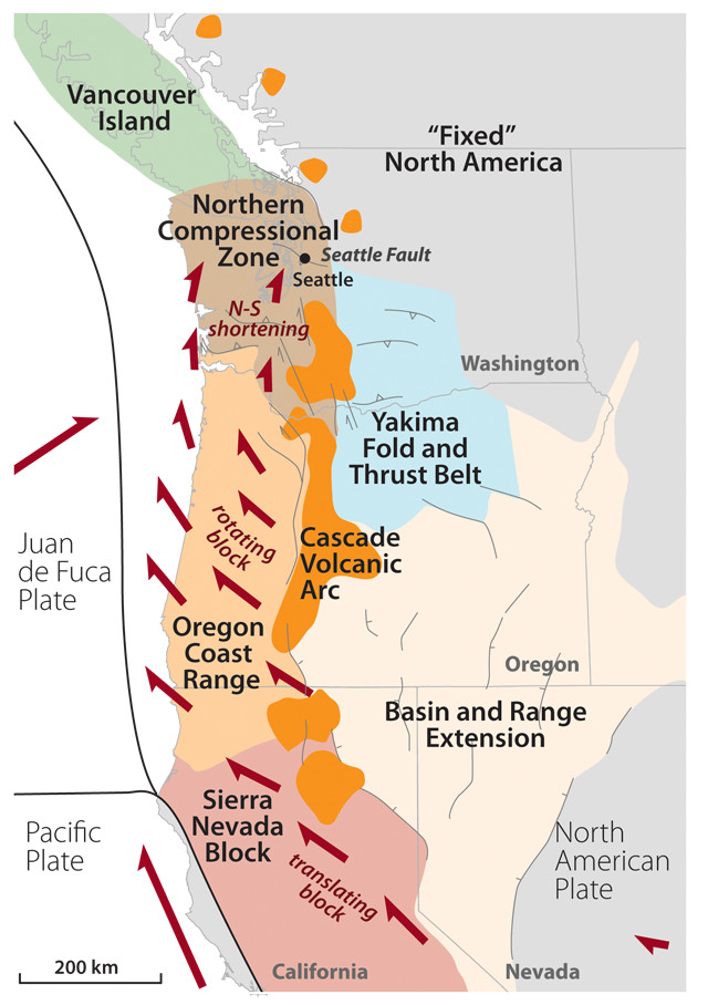
As tectonic movements push the Sierra Nevada Mountain block northwest, it butts into another block of hard rock, encompassing the Oregon Coast Range, which rotates slightly to the north and pushes northward into Washington. The Cascade volcanic arc (orange) erupts along the trailing edge of the Oregon block in a region of crustal extension. The northward motion of the Oregon block squeezes western Washington (brown) against the Canadian Coast Mountains, causing compression, uplift, thrust faulting and earthquakes in the Seattle Fault Zone. Kathleen Cantner, AGI, after Wells et al., Geology, 1998.
In response to the discovery of the fault zone, both Seattle’s Office of Emergency Management and Department of Planning and Development have rewritten building codes and hazard planning. “It took a while for people to realize the extent of it, but the Seattle Fault has focused our attention on the seismic threats,” says T.J. McDonald, a hazards analyst for Seattle.
Unlike the faults involved in earthquakes that hit Seattle in 1949, 1965 and 2001, the Seattle Fault is just below the surface and not deeply buried, which means that a rupture would have a greater effect at the surface.
Perhaps the biggest remaining challenge is getting a better handle on how often the Seattle Fault has ruptured in the past, and thus when it might rupture again. New technology, such as lidar (Light Detection and Ranging) and GPS, has helped geologists better locate the faults and track movement, but it hasn’t helped date past movement. For example, the uplift of 1,100 years ago appears to be the lone occurrence in the last seven to eight millennia, but other nearby faults show evidence for three or maybe four movements in the past 2,500 years. Without better dating, Sherrod says, it is hard to say if the recurrence interval is a thousand years or many thousands of years.
Seattle residents live in one of the most seismically interesting parts of the country, Sherrod says. These faults present “a world-class problem right here in our backyard.”
Some information and the quote from Sam Johnson were excerpted, with permission, from Williams’ book on Seattle geology, “Street Smart Naturalist” (2005).
© 2008-2021. All rights reserved. Any copying, redistribution or retransmission of any of the contents of this service without the expressed written permission of the American Geosciences Institute is expressly prohibited. Click here for all copyright requests.