
by Mary Caperton Morton Thursday, November 12, 2015
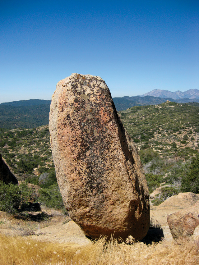
This fragile rock stack in the Grass Valley area of the San Bernardino Mountains in California lies near the San Andreas Fault, one of the most seismically hazardous areas in the United States. Credit: Lisa Grant Ludwig.
Precariously balanced boulders look like bizarre accidents in any landscape, but when they’re found in regions famous for frequent earthquakes, such gravity-defying formations are even more improbable. Scientists have long wondered about an odd collection of dozens of balanced boulders in the San Bernardino Mountains that seemingly should have been toppled centuries ago by the earthquakes that regularly shake Southern California. Even stranger, these car- to house-sized granite boulders are located within 10 kilometers of the active San Andreas and San Jacinto faults. Now, new detective work on 36 of the boulders is giving scientists clues about the connections between these faults.
“In most places, the closer you get to an active fault, the fewer precariously balanced rocks there are. But these boulders sit right along the San Andreas and San Jacinto faults, so the big question is, ‘how could they have survived the multiple earthquakes that have struck this region?’” says Lisa Grant Ludwig, a geophysicist at the University of California, Irvine, and lead author of the new study, published in Seismological Research Letters.
Grant Ludwig and her colleagues first used beryllium-10 dating, produced during exposure to cosmic rays from the sun, to determine how long the boulders have been sitting at the surface. They found the majority of the 36 rocks studied had been exposed for 10,000 to 18,000 years — making them old enough to have experienced about 100 large earthquakes and still remain standing.
“Initially, we were pretty stumped as to how these rocks could still be standing. Some look like they’re ready to topple over any second,” Grant Ludwig says. To test the fragility of the standing rocks, which erode out of the ground in their balanced positions, Grant Ludwig and colleagues used a number of methods, including three-dimensional physical models placed on shake tables in the lab, and tilt-tests on the actual rocks in the field — meaning a force is applied to slightly move the boulders — none of which were actually toppled during testing.
“These different methods, both in the lab and in the field, serve as cross-checks for each other. With some rocks, it’s possible to use all the methods, for others it’s not because they are too dangerous, or too fragile, or too inaccessible,” she says.
Based on their tests, the researchers found that all 36 of the rocks should have been toppled by the ground motion produced by one or more of the earthquakes that have struck this region in the last 10,000 years, such as the magnitude-7.9 Fort Tejon temblor in 1857.
Grant Ludwig and her colleagues surmise that connections deep underground between the San Andreas and San Jacinto faults could somehow dissipate earthquake ground motions in this particular region, leading to less shaking in the area where the boulders are still standing.
“The San Andreas and San Jacinto faults run very close to each other and we think ruptures can jump between the faults,” Grant Ludwig says. The phenomenon of energy transferring between faults is not well understood, but modeling scenarios indicate that the resulting ground motions can sometimes be increased, or, as seems to be the case in this area, decreased, she says.
Ruptures involving both the San Andreas and San Jacinto faults aren’t typically considered by current hazard maps, Grant Ludwig says, which depict the two fault systems separately. Seismic hazard maps produced by the U.S. Geological Survey summarize probability levels for earthquake-generated ground motions across the United States and are used to establish building codes, insurance rates, risk assessments and other public policies. “A lot of factors go into creating these maps,” Grant Ludwig says, but data from balanced boulders are not always included. “These anomalous standing rocks may be indicators of where ground motion behaves differently.”
“There are a lot of uncertainties in generating these maps,” says John Anderson, a seismologist at the University of Nevada in Reno, who was not involved in the new study. “But just because a precarious rock is not consistent with the current versions of the national hazard map doesn’t mean you should throw out the whole map,” he says. Instead, he says the rocks should be seen as important clues that something unusual is going on in the region around the balanced rocks. “A higher density of instruments in this region should allow for testing of the ground motion models against actual data,” he says, which could be used to improve hazard maps.
© 2008-2021. All rights reserved. Any copying, redistribution or retransmission of any of the contents of this service without the expressed written permission of the American Geosciences Institute is expressly prohibited. Click here for all copyright requests.