
by Mary Caperton Morton Thursday, November 9, 2017
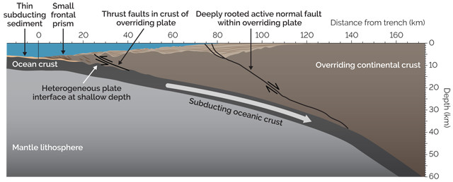
This diagram shows the generalized structure of the subduction zone off the Alaska Peninsula near the Shumagin Islands. A large normal fault cuts through the entire overriding North American Plate at a roughly 45-degree angle and connects to the megathrust fault along which the North American and Pacific plates move against each other. Credit: K. Cantner, AGI, based on data from Bécel et al., Nature Geoscience, 2017.
In 2011, a large swath of coastal Japan was devastated and more than 15,000 people were killed when the magnitude-9.1 Tohoku earthquake unleashed massive tsunami waves that inundated land with run-up heights of 30 meters in places. In a new study, researchers have discovered that the seafloor off the Alaska Peninsula exhibits structures and fault patterns similar to the region where the Tohoku quake originated — a finding that may indicate a higher tsunami risk for coastal Alaska than previously thought.
Catastrophic tsunamis are generated by large earthquakes along subduction zones, where one tectonic plate dives under another, creating a trench on the ocean floor. When stored tension is released during an earthquake, the seafloor can lurch up or down, displacing large quantities of water and creating surface waves that can travel across ocean basins as fast as 800 kilometers per hour and loom stories high as they approach coastlines. During the Tohoku earthquake, a chunk of the leading edge of the Eurasian Plate, which overrides the downgoing Pacific Plate, broke from the rest of that plate, slipping upward more than 50 meters along a fault that angles off from the main subduction zone fault. The sudden upward movement of this segment set off the deadly tsunami.
In the new study, published in Nature Geoscience, researchers led by Anne Bécel and Donna Shillington, both of Columbia University’s Lamont-Doherty Earth Observatory, found a similar orientation of faults beneath the seafloor off the coast of the Alaska Peninsula, where the Pacific Plate dips below the North American Plate. In an area known as the Shumagin Gap, near the Shumagin Islands, the team used a combination of seismic reflection and refraction, as well as recent bathymetric data, to map the seafloor and subsurface fault structures in greater detail than ever before.
“This is by far the best seismic imaging that has been done for this area,” says Jeff Freymueller, a geophysicist at the University of Alaska Fairbanks who was not involved in the study. “This project is very important in that it provides the first modern high-quality data of the area.”
The imaging revealed a normal fault in the overriding plate that runs the entire thickness of the plate, almost 32 kilometers deep, from the seafloor all the way down to where the two plates move against one another. Normal faults arise in extensional tectonic environments, where portions of Earth’s crust are pulling apart, and are unusual in subduction zones, Freymueller says. “We usually think of subduction zones as places where everything is under compression,” he says, so “finding an extensional fault here is somewhat unexpected.”
The newly mapped fault lies between the subduction zone trench and the coast, paralleling the peninsula for about 140 kilometers. On the seafloor, 5-meter-tall scarps seen in the team’s imaging show where movement along the fault has dropped one side and raised the other. “This fault may allow the outer part of the plate closest to the seafloor to slip more in the event of an earthquake and create a tsunami,” Shillington says. “This aspect has not yet been factored into hazard scenarios for this region.”
The Alaska Peninsula has experienced many earthquakes in the last few hundred years: A magnitude-8.6 event in 1946, for example, produced a large tsunami that killed people in mainland Alaska, Oregon and California, and sent waves as far as Papua New Guinea and Antarctica. The Shumagin Gap itself may have ruptured in 1788, producing a deadly tsunami, according to historical accounts of Russian colonists on nearby Unga Island.
Similar tsunamigenic fault structures may also be found along other subduction zones, Shillington says. “From Tohoku, we recognize that structures like this normal fault are associated with large tsunamis, but the kind of deep-penetration seismic reflection data we were able to acquire off of Alaska have only been collected in a few other subduction zones around the world,” she says. “Hopefully, there will be more opportunities to collect data in other places to look for similar structures. More information may help us predict how large of a quake might occur, and how tsunamigenic it might be.”
© 2008-2021. All rights reserved. Any copying, redistribution or retransmission of any of the contents of this service without the expressed written permission of the American Geosciences Institute is expressly prohibited. Click here for all copyright requests.