
by Mary Caperton Morton Wednesday, September 3, 2014
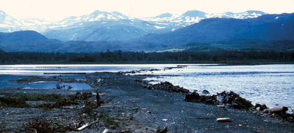
This road along Womens Bay on Kodiak Island is in an area that subsided nearly 2 meters during the 1964 earthquake. Credit: U.S. Geological Survey Photographic Library.
In 1964, a magnitude-9.2 earthquake ruptured two segments of the Alaskan megathrust fault along more than 900 kilometers from Prince William Sound to Kodiak Island. Historical and paleoseismic evidence has hinted at previous events in this region in 1788 and about 1100, and now a team working on Kodiak Island has found clues of another large event that struck about 500 years ago. The find makes the recurrence interval for the tsunami-producing fault much shorter, potentially increasing the earthquake and tsunami hazard profile, not only for Alaska, but also Hawaii and California.
“There’s a temptation, when you’ve had a large, instrumented event like the 1964 earthquake, to assume that event is typical of the pattern, size and type of rupture for a particular fault,” says Ian Shennan, a paleoseismologist at Durham University in England and lead author of the new study published in Geology. New paleoseismic evidence shows, however, that for the Kodiak segment of the Alaskan megathrust, the 1964 event might not be typical. Instead, Shennan says, “it’s becoming pretty clear that the rupture pattern is not always as simple as in 1964. We see that the two segments have ruptured separately at least twice in the past thousand years.”
The Prince William Sound segment of the megathrust has been studied much more extensively than the neighboring Kodiak segment, with paleoseismic records going back 5,000 years. Kodiak Island, located 900 kilometers south and west of Prince William Sound, likely has similar records available, Shennan says, but it has not received as much attention, mainly due to the remote location and difficult logistics of working on the island, which lies south of Homer, Alaska.
To piece together a more complete record for Kodiak, Shennan and colleagues searched for paleoseismic evidence of earthquake-produced subsidence and tsunamis in marsh sediments on Kodiak Island. They found records aligning with the 1788 event, which destroyed the Russian port at Three Saints Bay on the island, for which there is a detailed historical record. They also found evidence for an earthquake between 1020 and 1150 and another event between 1440 and 1620, which they nicknamed the “500-year-old quake.”
“These indicate shorter intervals between ruptures of the Kodiak segment than previously assumed, and more frequent ruptures than for the Prince William Sound segment,” Shennan and colleagues wrote in Geology.
The evidence is strong enough that it should be taken into account when reassessing the hazard profile for the Alaskan megathrust, says Robert Witter, a paleoseismologist with the U.S. Geological Survey in Anchorage, Alaska, who was not involved in the new study. “I think this will definitely change the hazard profile. We thought it was a roughly 600-year recurrence interval, but they are showing that the Kodiak segment seems to rupture much more frequently, and that there may be a tsunami source at Kodiak that has not yet been identified.”
The next step will be to continue to extend the paleoseismic record for the Kodiak segment further back in time, with the goal of matching up with the 5,000-year-long Prince William Sound record. “Even with this new study, we’ve just barely scratched the surface on Kodiak,” Witter says.
© 2008-2021. All rights reserved. Any copying, redistribution or retransmission of any of the contents of this service without the expressed written permission of the American Geosciences Institute is expressly prohibited. Click here for all copyright requests.