
by Kathryn Hansen Monday, January 23, 2012
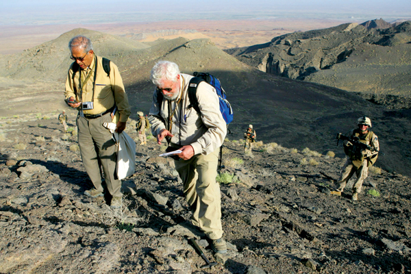
Geologist Said Mirzad (left) surveyed Afghanistan's mineral resources with colleagues from the U.S. Geological Survey and the Afghanistan Geological Survey (and a military escort). Courtesy of Said Mirzad
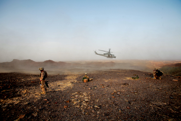
Marines from the First Reconnaissance Battalion, C Company, stand guard as a helicopter drops to pick up civilian scientists at the Khanneshin carbonatite complex in August 2010. Tina Hager, TFBSO
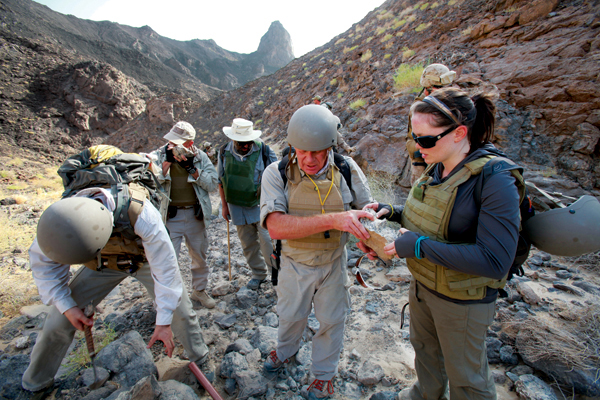
Forrest Horton (left), Robert Tucker (middle), and Emily Scott come across the first sign of rare earth element mineralization in the Khanneshin carbonatite complex. Tina Hager, TFBSO
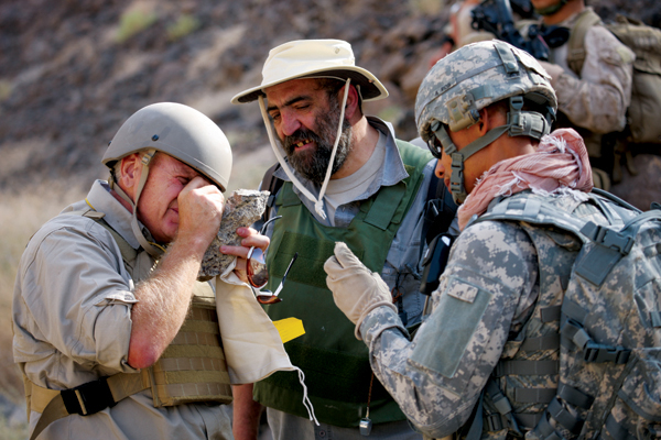
Robert Tucker (left), Alex Chairhorsky (middle), and a Marine look at a specimen of rare earth element minerals from the Khanneshin massif. Tina Hager, TFBSO
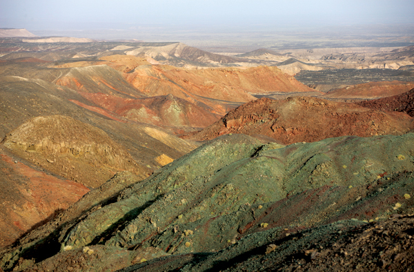
The Khanneshin carbonatite complex hosts rare earth elements. Tina Hager, TFBSO
Each donning about 10 kilograms of protective gear, including helmets and Kevlar, scientists trudged up the rugged, rocky volcanic terrain of southern Afghanistan, slowing now and then to catch an extra breath of thin air. Some carried guns. Others carried rock hammers.
The trek from the helicopter and up a volcano in Afghanistan’s Helmand Province confirmed the presence of an estimated 1 million metric tons of rare earth elements, previously mapped by airborne hyperspectral imaging. Farther north, similar expeditions assessed other mineral resources, notably gold, iron and copper, described in reports issued in September 2011 by the U.S. Geological Survey (USGS). The detailed depiction of what USGS calls “world-class resources” gives the Afghan government a tool that could help reshape the country’s war-torn landscape.
The reports are the culmination of a two-phased project that began in 2004, building on an earlier USAID-funded USGS project, and ended in a 2007 report giving resource estimates. Since 2009, USGS and the Department of Defense have been working to identify, confirm and describe resources in two dozen areas of interest. EARTH has been following the story, from the initial USGS estimate of massive mineral potential, to the struggles faced by geologists working amid a war environment. Now, as the project wraps up and the data packages are handed over to Afghanistan, we take an in-depth look at the study and its results, and ask the experts about the implications for the country’s future.
“Some say that abundant mineral wealth will save Afghanistan, that their problems will be ended because now they have internal funding based on resources, while others say it’s impossible,” says Wayne Pennington, a geophysical engineer at Michigan Tech University. Pennington recently finished serving as the Jefferson Science Fellow working with USAID as a senior engineering advisor, a role in which he worked to improve methods of infrastructure development in post-disaster and post-conflict settings such as Pakistan and Afghanistan. “The truth, in my opinion, is somewhere in between,” he says.
Twenty-four rectangles contrast with the curvy outlines on a map of Afghanistan’s provinces. The boxy “areas of interest” aren’t political borders; rather, they’re the areas reported in 2007 by a team of scientists led by Stephen Peters, an economic geologist at USGS in Reston, Va., to be the most likely locations to economically develop nonfuel mineral resources.
“We thought that these areas in particular would be the most likely to be developed and pose the least risk for investors,” Peters says.
The box-drawing project, in collaboration with the Afghanistan Geological Survey (AGS), relied heavily on the consolidation of information that came from the discoveries and rediscoveries of previous generations. Many of the original discoveries go back to ancient times, to Genghis Khan and Alexander the Great, according to Peters. But it was the Soviets who in the 1960s and early 1970s were the first to map Afghanistan’s geology in great detail. That work was disrupted, however, by the region’s subsequent invasions and civil wars, which drove AGS scientists to hide the records as city facilities and the survey’s facility were destroyed.
Then, when the AGS in Kabul started to be refurbished in 2004, reports — some punctured with bullet holes — started to be re-examined.
“Work done in the 1970s was not common knowledge,” says Robert Tucker, a geologist at USGS in Reston, Va. “When copied and translated, we really began to appreciate the exceptional magnitude of the work the Soviets had done.”
Compiling the wealth of existing data, the USGS teams released the “2007 Preliminary Assessment of Nonfuel Mineral Resources of Afghanistan,” describing abundant mineral deposits such as copper, iron and rare earth elements. In 2010, U.S. defense officials valued the deposits of copper, cobalt, gold and lithium to be worth about $1 trillion, according to United Press International.
The reports sat until 2009, when the Department of Defense Task Force for Business and Stability Operations contracted USGS and AGS for further study, as one means toward providing wealth and stability to the country. The partnership started a new chapter in the research, providing USGS and AGS with access and security to perform on-the-ground evaluation and confirmation of what lies within the 24 boxes.
“What surprised me was the extent of knowledge that already existed concerning the mineral deposits, but it was scattered in various languages and reports we might consider to be obscure,” Pennington says. “USGS did an excellent job in pulling those together and making them accessible.”
In September 2011, USGS announced the results of two more years of study in the report, “Summaries of Important Areas for Mineral Investment and Production Opportunities of Nonfuel Minerals in Afghanistan.” Information packages for each area of interest include a summary of the deposit, a map and analysis. Highlights include an estimated 1 million metric tons of rare earth elements in the Khanneshin carbonatite area in Helmand Province. Among the other areas described: substantial copper and cobalt deposits near Kabul, iron-rich areas in central Afghanistan, and copper and gold deposits in the southeast.
Afghanistan lies at the juncture of several microplates, giving it a wide range of exotic terranes (rock packages) and varied deposits, all in close proximity. The collision of the plates, particularly uplift of the India Plate, has led to mountain building and the exposure of young sediment.
The rocks are free of vegetation and completely exposed. Thus the geology helps Afghanistan in two ways: First, the tectonic processes put the mineral resources there in the first place. And second, it’s pretty easy to find the minerals. Peters calls flights over the region “a geologist’s dream,” and it makes observations by remote sensing — and by digging geologists — a lot simpler.
The deposits aren’t that unique globally, but they are unspoiled. “There are other places that have as good a collection of minerals, for example, the North American West,” Pennington says. “The difference is that the American sites have already been developed whereas the Afghan sites have been left undeveloped, so the minerals are still waiting to be picked up.”
In 2009, Peters and colleagues set out to evaluate the prospects in person, to look at the minerals, and to verify what remote sensing technology had suggested might be in the rocks. For Tucker, that involved fieldwork to the world-class iron deposit northwest of Kabul, two copper systems in Herat Province, and then south to the Khanneshin deposit in Helmand Province. “It was the trip to Helmand Province where I did my best science,” Tucker says.
The province is home to a young volcano, less than 1 million years old, strewn with carbonatitic deposits. The region was thought to be a hot spot for rare earth elements.
“Anyone in Silicon Valley will tell you the importance of rare earth elements,” Tucker says. They turn up in all kinds of technologies, from optics for communications to lightweight alloys useful in aircraft and wind turbine industries. For now, 97 percent of rare earth elements come from China.
The team’s treacherous hike through the volcanic landscape paid off. They returned with promising samples, enough to convince the Task Force for Business and Stability Operations of the Department of Defense to support a return trip last February.
“We hit paydirt,” Tucker says. “The trip was successful beyond my wildest imagination. There were signs of mineralization everywhere, suggesting that we hit upon something world-class.”
The team returned with many samples showing that the rare earth content of the enriched rocks is of exceptional grade, several orders of magnitude above that of common rocks in the volcanic complex, which makes the extraction process much easier. Not to mention the tonnage — an estimated 1 million metric tons — which at current rates of global consumption could sustain demand for a decade. And, Tucker says, that estimate is a conservative one, as the deposit could possibly extend to greater depths than the teams could measure without drilling.
Samples from all of the sites were sent to accredited labs for comparison with the Soviet samples, which Peters says for the most part, “jibed very well.”
“The thoroughness [of the fieldwork] is not ideal,” Peters says, noting that time on the ground to study sites ranged anywhere from 30 minutes to five hours. “Geology has not been done in detail in a modern sense. The downside is that it’s still a war zone and security issues remain. This report is by no means the final story, but it’s a good start.”
And although there remains some uncertainty as to the extent of the deposits, Pennington says, “the prognosis is extremely encouraging and could play a significant role in recovery from decades of war.”
Peters’ team compiled the geologic and hydrologic information into a usable GIS framework, convenient for review by prospective investors, and released the package on Sept. 29, 2011.
The next step is up to Afghanistan’s Ministry of Mines, which is working on tendering packages for six of the 24 areas of interest, rounding out the scientific data with information on mining laws and regulations and conditions of the bid. Current activities described by the ministry include “restructuring [and] developing an investor-friendly regulatory regime.” Toward that effort, the country has become a candidate in the Extractive Industries Transparency Initiative, which sets a global standard for transparency in mining, oil and gas practices. “It’s not like the U.S., where you simply stake a claim,” Peters says.
An Afghan mining law passed in 2006 provides investment security and other regulations to attract investors on a global scale. “To date, this has been a challenge for the new democracy,” Pennington says. There needs to be a lack of corruption, he says, and investors need to feel that bids are being entertained openly and fairly. The system in Afghanistan seems to be set up in such a way that current tenders are being handled properly, but there also needs to be confidence in the physical security of workers and materiel. Finally, there needs to be confidence that contracts will be honored and agreements held in the future. “All of these uncertainties in the current environment add to the risk faced by any potential developer.”
Already, China has won the bid for one of the Aynak copper deposits just south of Kabul, and is currently doing feasibility studies for building a railroad line and opening a coal mine to support it. “I would imagine that China will be interested in a number of the other deposits as well, but also I would hope that any of a number of Western or other Asian companies and countries will be involved in the development of the other prospects,” Pennington says.
Once bids are won, the challenge remains of developing the infrastructure necessary to effectively and economically develop the deposits. That includes building the economic and political infrastructure addressed by the Ministry of Mines, and also the physical infrastructure: electricity, access to oil and gas, and railways.
“We [USGS] think it’s a critical story going forward in Afghanistan,” says Jack Medlin, director of USGS activities in Afghanistan, based in Reston, Va. “If you want to do mineral resource development, there are two things you need to pay attention to: water and energy resources. Where is the power going to come from? You can’t develop these large mineral deposits without energy.”
The resources to develop some of the physical infrastructure are in Afghanistan’s own backyard. Gold, iron, copper and rare earth elements have generated a lot of buzz following the assessment, but there was also work to delineate industrial minerals that Afghans need to build up the country’s infrastructure. Limestone and marble, for example, can be used to make cement. Clay can be turned into brick. And a variety of materials could be used to build roads and railroads.
“USGS’ primary purpose from day one for being in Afghanistan is to train the Afghans in modern assessment and modern technologies used around the world in the exploration and assessment of mineral resources, so we can leave and they can do these things themselves,” Medlin says.
That, however, requires that there be local experts, and that they be trained in mineral studies and be able to access the reports. Although some who risked their safety and livelihoods protecting documents during some of the worst phases of war remain involved with the survey, they are few and far between, according to Pennington. “An entire generation of scientists and technicians is missing.” And for those who remained, the AGS had long been nothing more than an empty shell of a building pocked from bullets, without the computers and technology to access data.
“After 30 years of war it’s easy to imagine the capabilities of any institution, including the Afghanistan Geological Survey, would be extremely limited,” Pennington says.
Still, progress is evident in the refurbishing and opening of the AGS facilities in June 2006, which transformed it into a modern building complete with a computer center that meets hardware and software needs to access and study old and new data, from historical documents, to the new assessment’s maps and digital layers of data.
“Any development in Afghanistan must include the participation of Afghan technicians, laborers and engineers, and we see that in the USGS report,” Pennington says. USGS worked closely with the Afghanistan Geological Survey for much of the ground calibration, and appears to have involved Afghan personnel in all aspects of the study, he notes.
USGS funding and involvement ended with the hand off of the data packages last September. Still, scientists say there is more to be done. The existing 24 areas of study were targeted primarily because that’s where existing historical data pointed. But researchers say there could be up to 40 other areas yet to be mapped and measured as part of Afghanistan’s untapped mineral wealth.
© 2008-2021. All rights reserved. Any copying, redistribution or retransmission of any of the contents of this service without the expressed written permission of the American Geosciences Institute is expressly prohibited. Click here for all copyright requests.