by Sara E. Pratt Saturday, February 25, 2012

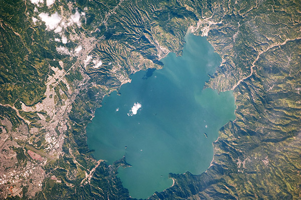
A massive eruption of Ilopango volcano in El Salvador, today a crater lake, may have triggered the global climate cooling of A.D. 536. The only historical eruption at Ilopango took place in 1879-1880, during which a lava dome formed creating the Islas Quemadas in the central part of the lake. NASA Earth Observatory
El Salvador’s Lake Ilopango, near the capital city of San Salvador, is known for boating, diving and the rugged, scenic beauty of its 100 meter-tall cliffs --- the lip of the caldera that holds the lake. However, 1,500 years ago, it may have been the site of one of the most horrific natural disasters in the world. It may also be the long-sought cause of the extreme climate cooling and crop failures of A.D. 535-536, reported Robert A. Dull of the University of Texas at Austin at the Association of American Geographers annual meeting in New York this week.
New research on the extent and the timing of the eruption now places the eruption --- previously thought to have occurred three centuries earlier --- at the right time and place. The massive Plinian-type event with pyroclastic flows would have instantly killed up to 100,000 people, displaced up to 400,000 more and filled the skies with ash and dust for more than a year. The new findings would make it the second-largest volcanic eruption in the last 200,000 years. “This event was much bigger than we ever thought,” Dull said.
Such an eruption would explain the episode in Mayan history known as the Classic Period Hiatus, when the Maya stopped building stelae, decorative stone columns erected to mark events, Dull said. It would also finally explain the global cooling of A.D. 535-536, an 18-month period of cloudy skies, crop failures and famines that was described in both Roman and Chinese historical accounts. “So it’s very well established this event took place,” Dull said. “The question has been the cause.”
The cooling, known as the A.D. 536 event, had been attributed to a number of sources over the years including a bolide impact. In 2008, analysis of ice cores recovered in Greenland and Antarctica — dated to A.D. 536 — showed similar levels of sulfate, indicating a massive tropical volcanic eruption had ejected ash around the planet. However, the location of a tropical volcano that erupted in A.D. 536 and produced a sufficient volume of ash to block the sun remained unknown. Some suggested Rabaul; others Krakatoa. But the dates and sedimentary evidence didn’t align.
In 2001, Dull had re-evaluated carbon-14 dates of a thick, white layer of tephra, locally called the Tierra Blanca Joven (TBJ), or “young white land,” which had placed the Ilopango eruption at A.D. 260. Dull’s 2001 analysis placed it sometime between A.D. 408 and 536. At the time, however, the TBJ eruption was not thought to have been large enough to have caused global cooling.
Over the last few years, however, other researchers have discovered TBJ tephra deposits — dated from A.D. 400 to 600 — even further afield, in Nicaragua, Honduras and in offshore deposits. The wider geographic distribution of TBJ deposits indicates the eruption produced a much larger volume of ash and debris, which Dull now calculates at 84 cubic kilometers, nearly five times larger than previously thought. “An eruption that big has to leave a big hole in the ground,” Dull said, and the dimensions of Ilopango’s caldera, at 11 kilometers by 17 kilometers, fit the bill. Such an eruption would merit a rating of 6.9 on the Volcanic Explosivity Index, larger than the 1816 eruption of Tambora, which caused the “year without a summer.”
Meanwhile, new carbon-14 dates from a tree that was killed and preserved by a pyroclastic flow have placed the Tierra Blanca Joven eruption between A.D. 450 and 545. “That’s a very good fit for this radiocarbon data,” Dull said. “It’s convinced us that we have found the source.”
© 2008-2021. All rights reserved. Any copying, redistribution or retransmission of any of the contents of this service without the expressed written permission of the American Geosciences Institute is expressly prohibited. Click here for all copyright requests.