
by Arielle Emmett Tuesday, June 5, 2018
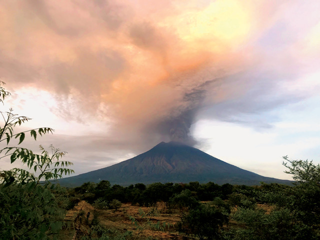
Mount Agung on Bali erupts in November 2017. It is one of nearly 80 volcanoes in Indonesia that have erupted in recorded history. Credit: Michael W. Ishak, CC BY-SA 4.0.
With a little imagination, it’s not hard to see a natural hazard map of Indonesia as a dartboard with many bull’s-eyes. Throw a dart anywhere in the vicinity of the 18,000 islands that make up the Indonesian Archipelago, and it will almost certainly land close to more than one active volcano, and near areas severely impacted by past earthquakes and tsunamis, as well as dozens of fires, floods, tornadoes and landslides, which all routinely disrupt this country’s lush beauty.
Indonesia sits atop a tectonically complex region along the Pacific Ring of Fire — the volatile region of earthquake and volcanic activity that encircles the Pacific Ocean. And, by virtue of the archipelago’s equatorial location and its array of physiographically diverse islands, different parts of the country are subjected to a wide variety of weather, from drenching monsoon rains to prolonged dry spells.
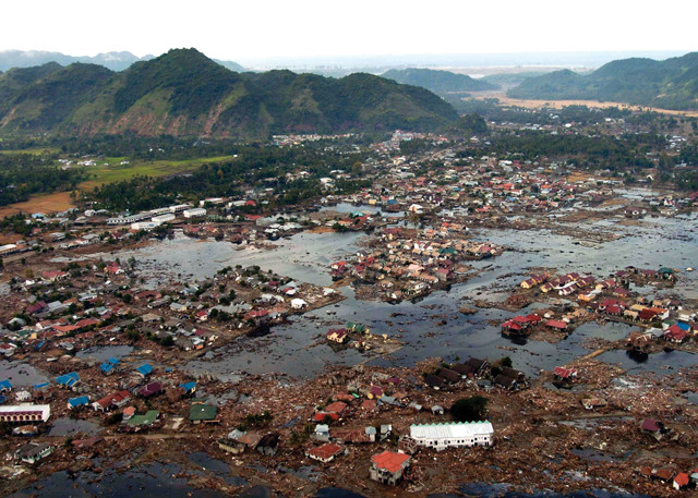
A flooded suburb of Banda Aceh, at the northwest tip of Sumatra, following the December 2004 Indian Ocean earthquake and tsunami, which inundated large swathes of coastline in Indonesia, Thailand and elsewhere around the region. Credit: U.S. Navy photo by Photographer's Mate 2nd Class Philip A. McDaniel.
I visited the islands of Java, Sumatra and Bali in December 2017 — my third visit to Indonesia in three years — eager to catch up on friendships and learn how carefully the country was monitoring its earthquake, tsunami and volcanic hazards. On my mind were the catastrophic 2004 Indian Ocean earthquake and tsunami that struck just west of Sumatra’s Aceh Province, claiming the lives of more than 170,000 Indonesians and roughly 270,000 people around the region.
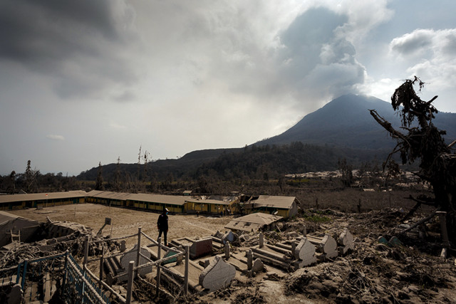
Volcanic ash covers a school and cemetery near Sinabung in January 2014. Sinabung began erupting in 2010 after a centuries-long dormancy, and has been very active since 2013. Credit: Rendy Cipta Muliawan, CC BY 2.0.
In recent years, the Indonesian government, along with other groups like the Earth Observatory of Singapore and the U.S. Pacific Tsunami Warning Center, has been introducing technologies to improve hazard forecasting, warning and mitigation. Among these technologies are GPS systems enabling precision geodetic measurements of plate tectonic movements and stresses; tidal gauges; gas-sniffing drones and temperature sensors for volcanic monitoring; and a new set of integrated databases and communications systems providing hazard detection and visualization, decision support, and earthquake and tsunami warning protocols.
But how effective are these technologies in helping safeguard the country’s populace? Indonesia is a country with 55,000 kilometers of coastline and more than 266 million inhabitants living on 6,000 islands, many of which are among the most remote in the world, where cellphone and internet coverage is rare. I wanted to understand whether the government’s efforts to communicate about hazards were reaching its far-flung residents, and if disaster preparedness based on folklore and “local wisdom” might be equally important — or more so — than monitoring and warning technologies.
Few people outside the region understand just how regularly natural disasters occur throughout Indonesia’s 5,000-kilometer-wide archipelago. More than 2,000 serious disasters are reported each year, 90 percent of which are weather-related — mostly the result of flooding rains, tornadoes, fires and mudslides. In 2017, Indonesians reported 787 floods, 716 tornadoes, 614 landslides, and 96 forest and ground fires (burning peat lands and rainforests to make room for large palm oil plantations and smaller farms is a popular practice, especially in Sumatra). Indonesians also reported 19 regional droughts, two volcanic eruptions — at Mount Sinabung on Sumatra and Mount Agung on Bali — and 11 tsunamis. Overall, 3.4 million people were displaced that year by these natural disasters.
Indonesia experiences roughly 4,000 earthquakes a year, 70 to 100 of which are magnitude 5.5 or higher, along with one or two highly destructive quakes, some reaching or exceeding magnitude 8. Hazard maps created by the Indonesian Agency for Meteorology, Climatology and Geophysics, known as BMKG (Badan Meteorologi, Klimatologi, dan Geofisika), show that earthquakes and tsunamis are particularly frequent on those islands directly adjacent to the boundaries of the tectonic plates that meet in Indonesia’s midst — specifically the Indo-Australian, Pacific, Philippine Sea and Sunda plates — which are continuously moving and straining against one another.
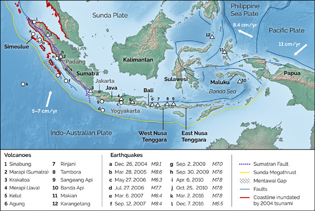
Earthquakes, volcanic eruptions and tsunamis often impact Indonesia as a result of the archipelago's location amid many colliding tectonic plates. This map shows some of the major earthquakes that have struck Indonesia in recent years, along with the inundation zone of the massive December 2004 tsunami and a sampling of the country's many active volcanoes. Credit: K. Cantner, AGI.
Off the western and southern coasts of Sumatra, Java and Nusa Tenggara, for example, the Indo-Australian Plate subducts under the Sunda Plate at a speed of 5 to 7 centimeters per year, building up stress that’s occasionally released as large earthquakes. A chain of active volcanoes — including Sinabung and Krakatoa among others — traces this plate boundary. To Indonesia’s northeast, meanwhile, the Philippine Sea Plate collides with the Sunda Plate to its west and the Pacific Plate to its east. And between all of these major plate collisions, just east of Java, a so-called “suture zone” up to 2,000 kilometers wide comprises several smaller plates that move against each other at relatively high speeds. Earthquakes happen along multiple subduction zones and other faults in the suture zone, too, especially around the “spice islands” of Maluku, Sulawesi, Papua, and smaller islands in the Banda Sea.
With all of this tectonic activity, the country also has 78 volcanoes that have erupted in recorded history. Most famous among them, perhaps, are Tambora in West Nusa Tenggara and Krakatoa, situated between Sumatra and Java, which erupted catastrophically in 1815 and 1883, respectively. In recent times, a 2010 eruption at Mount Merapi outside Yogyakarta in Java spewed plumes of ash, lahars and pyroclastic flows, along with a cloud of ash and sulfur dioxide that reached more than 15 kilometers into the atmosphere over the Indian Ocean, prompting the evacuation of 350,000 people. However, many chose to remain behind or return home while the eruption was still going on, and 350 people died.
In northern Sumatra, Mount Sinabung, which had been dormant for 400 years, began erupting in August 2010 and has been very active since 2013. Major eruptions in 2017, and again this past February, chased residents from the mountain, and Indonesia’s National Disaster Management Authority, known as BNPB (Badan Nasional Penanggulangan Bencana), determined that all residents had to be resettled permanently due to the volcano’s volatility. Meanwhile, Mount Agung, on Bali, came to life in late November 2017 after a hiatus of more than 50 years since its last explosive eruption in 1963. Thanks to advances in monitoring near Agung, plenty of warning signs were detected, enabling disaster personnel to order evacuations before the volcano actually blew, and there were no casualties. In 1963, by contrast, 1,500 people perished as a result of the unexpected eruption.
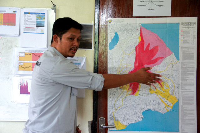
Devy Kamil Syahbana, a volcanologist with the Indonesian Center for Volcanology and Geological Hazard Mitigation, talks about how the November 2017 eruption of Mount Agung forced the evacuations of rural residents living near the volcano. Credit: Wibi Pangestu Pratama.
“Because of the technical changes in volcanic science, we have had fewer victims in the past 20 years,” says Devy Kamil Syahbana, a field specialist with the Indonesian Center for Volcanology and Geological Hazard Mitigation (Pusat Vulkanologi dan Mitigasi Bencana Geologi Badan) who monitors Mount Agung on Bali. “Two decades ago, we didn’t have broadband seismometers or multi-gas analyzer spectroscopy to give us insights into the physical processes inside a volcano,” he says. GPS satellites and temperature sensors were also lacking in the toolkit of Indonesian scientists at that time. “Now, volcanic eruptions are among the most predictable of geological disruptions,” Devy says. Seismic activity is another story. “You can’t predict earthquakes, and that hasn’t changed.”
Tsunamis present a different challenge. Only short warning times are available with current tsunami monitoring setups: generally between 10 and 60 minutes. And although disaster forecasting and warning technologies can help, none are perfect. In an incident that attracted international media attention, a March 2016 magnitude-7.8 earthquake that struck in the ocean roughly 800 kilometers southwest of Padang, Sumatra, resulted in tsunami warnings for parts of Indonesia, but no tsunami ever arrived. The tsunami warning caused widespread panic in Padang, a coastal city in western Sumatra where tsunamis are a major threat. Thousands of citizens fled to higher ground before the warning was canceled two hours later.
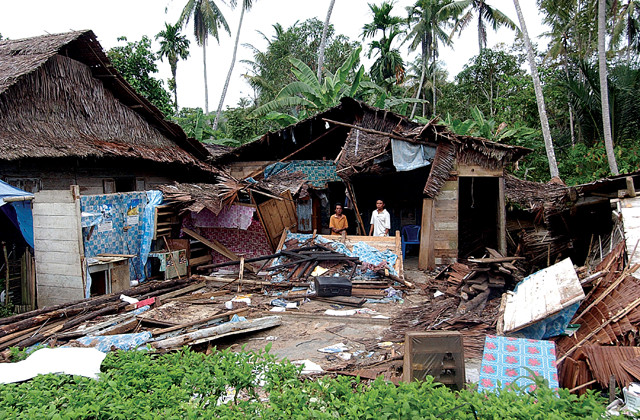
Two men stand amid debris after their home in a village on the island of Nias, west of Sumatra, was demolished by ground shaking during a magnitude-8.6 earthquake in March 2005. Credit: U.S. Navy photo by Photographer's Mate 2nd Class Jeffrey Russell.
While the temblor set off alarms in several different international tsunami warning systems, including Indonesia’s own, both local disaster specialists in Sumatra and national specialists in Jakarta were confronted with conflicting reports. One of the big problems was a complete lack of data coming from 22 ocean buoys deployed between 2006 and 2010 west of Sumatra by a team of German and Indonesian scientists to detect oncoming tsunamis. All of these buoys reportedly failed to work properly during the March 2016 incident.
“There were 22 buoys, and as of [2016], the last of them were not working due to them breaking down, or from theft or vandalism,” says Sutopo Nugroho, director of information for BNPB. Nugroho acknowledges the need for the buoys, but says the country doesn’t “have funding for maintenance or to replace them.”
When the buoys were first deployed, “they didn’t work very well,” says Jörn Behrens, a professor of mathematics at the University of Hamburg in Germany who was involved with the German-Indonesian tsunami warning system from 2006 to 2010. “Technically, the buoys did provide data, but they were placed too close to the potential tsunami sources,” he says.
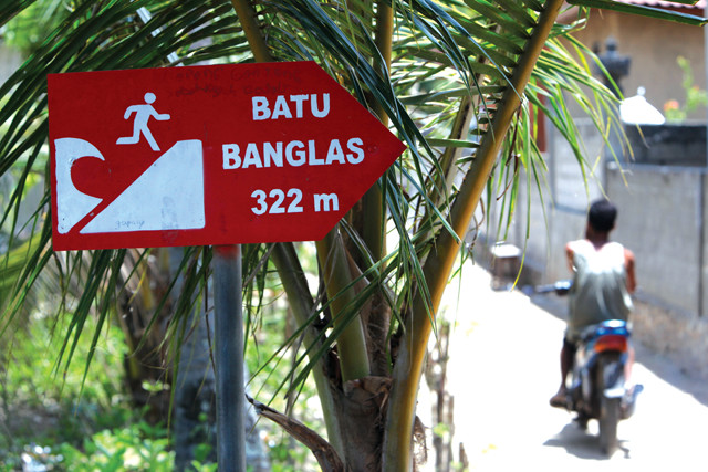
A tsunami hazard sign directs people toward high ground on Nusa Lembongan Island about 10 kilometers offshore Bali. Tsunami warning times in Indonesia are often short because of the close proximity of many islands to sources of major earthquakes, such as the Sunda Megathrust. Credit: ©iStockphoto.com/urf.
Indonesian islands are very close to earthquake sources like the Sunda Megathrust, the 5,500-kilometer-long subduction zone off Sumatra and Java that was the source of the cataclysmic 2004 earthquake and tsunami. The buoys' placement results in little delay between the detection of an earthquake and the potential generation of a tsunami wave. This makes it difficult for scientists to interpret two separate data streams coming from the buoys: one measuring seismicity (detected by ocean-bottom pressure sensors attached to the buoys) and another measuring anomalous wave heights at the water’s surface. “We couldn’t use the data except to say something severe had happened,” Behrens says. In the Pacific Ocean, by contrast, tsunami buoys are placed farther out in the ocean and away from tsunamigenic faults, so there is a time delay between seismic activity and the detection of a tsunami. Behrens believes the current dysfunctional buoys need to be replaced with a better-designed tsunami warning system.
Although seismologists and disaster mitigation authorities in the country have hoped to procure new technology to more quickly detect incipient threats, an array of nontechnical factors impedes progress. Conflicting agendas among multiple disaster agencies sometimes get in the way, as do limited funding for disaster monitoring and response, which influences both technology choices and civic responses. And on some islands, local officials often ignore warnings from disaster agencies, thinking the government is too often “crying wolf.”
“The challenge is the low capacity of local governments; they don’t put disaster risk awareness into their agenda,” Nugroho says. Many of Indonesia’s most remote villages also lack reliable communications and road infrastructure, so that residents may not hear sirens or radio warnings.
Moreover, in some circumstances, individuals have motivations that — knowingly or not — are at odds with monitoring efforts. Off western Sumatra, for example, fishermen and pirates have reportedly stripped the tsunami buoys, which cost more than $300,000 apiece, of sensitive electronic parts to sell. Others, meanwhile, have used the buoys to anchor their boats, damaging the buoys and disrupting their data transmission.
“You have to face the situation that these fishermen have to make a living and support their families, while a tsunami might occur in their area every hundred years or so,” Behrens explains.
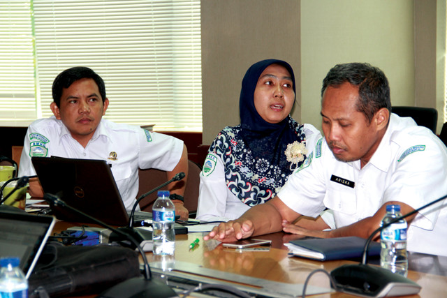
Indonesian Agency for Meteorology, Climatology and Geophysics (BMKG) earthquake and tsunami information specialists (left to right) Dr. Daryono, Weniza, and Ariska Rudyanto review data from the InaTEWS warning system. Credit: Wibi Pangestu Pratama.
Specific predictions of the timing and severity of natural disasters are not possible, but Indonesian disaster management agencies are making substantial progress in providing warnings of potentially dangerous events. Some critical system pieces are still missing in these efforts, however.
“Before 2012, even with the earthquake disasters of 2004 and 2009, Indonesia didn’t have good monitoring or warning systems for disaster management,” Nugroho says. “If we had an earthquake or volcano, and lots of citizens accessed our websites for information, too often the sites crashed,” he says.
In the past half-decade, however, Jakarta adopted a single, internationally recognized platform for monitoring and responding to natural hazards of all sorts in near-real time. The high-tech installation is known as InAWARE 6, a variant of DisasterAWARE, a multihazard warning and risk assessment system created at the Pacific Disaster Center (PDC) in Hawaii with support from the U.S. Agency for International Development. It is also deployed in Thailand, Vietnam and Nepal. The Indonesian version of DisasterAWARE, however, has been modified for scenarios that take the dispersed Indonesian islands into account.
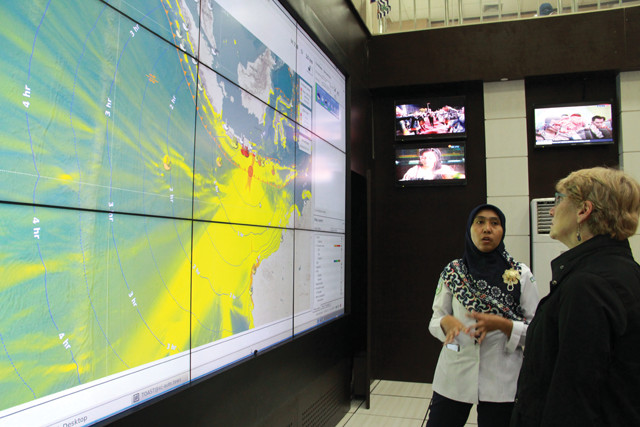
BMKG specialist Weniza explains the agency's InaTEWS warning system to the author. Credit: Wibi Pangestu Pratama.
At BNPB headquarters in Jakarta, a constantly changing InAWARE touchscreen displays the size and severity of Indonesian natural hazards, with colored bull’s-eyes indicating locations of earthquakes, volcanoes, fires, mudslides, tornadoes, storms and tsunamis. Using the platform, decision-makers can analyze data coming in from multiple regional and global feeds, such as seismic data from the U.S. Geological Survey, weather data from the National Oceanographic and Atmospheric Administration, and tsunami data from the Indian Ocean Tsunami Warning System and Indonesia’s BMKG.
“The challenge that remains is getting information to people in the ‘last mile' — people who need to know about it,” says Chris Chiesa, deputy director of the PDC. “Even if the warning system worked perfectly and instantaneously, even if SMS [text messaging] works one second after the ground shakes, for a nearshore earthquake [and tsunami] event, you’d have trouble a couple of kilometers away getting out of the inundation zone,” Chiesa says. “That wave is going to be there in five to seven minutes.”
BNPB’s companion agency, BMKG, which is in charge of all-island earthquake and tsunami warnings, relies on a separate warning system, known as InaTEWS (Indonesia Tsunami Early Warning System), which communicates some data to InAWARE but operates as a separate warning system for seismic hazards only. Built jointly with Germany and implemented over a three-year period in response to the 2004 Aceh-Andaman earthquake and tsunami, InaTEWS uses a network of 165 seismometers and accelerometers placed in the most seismically active island areas.
“We are now required to disseminate information and tsunami warnings to the country within five minutes after an earthquake,” says Weniza (she has one name), a tsunami information specialist with BMKG. “Initial warnings are sent via internet, radio, cellphone SMS and TV,” she says. Within 15 minutes, information from an accelerometer network helps the agency create a “shake map,” at which point a second warning may be issued, and confirming messages exchanged with other disaster agencies.
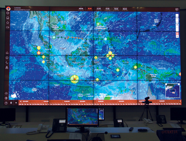
The interactive display of the InAWARE warning system at the headquarters of the National Disaster Management Authority (BNPB) in Jakarta shows natural hazards — volcanoes, earthquakes, flooding, landslides and other types — affecting Indonesia. Credit: Wibi Pangestu Pratama.
Meanwhile, following the failure of the 22 previously deployed buoys, BMKG still lacks a functional network of ocean buoys and deep-sea pressure sensors called DARTs (Deep-ocean Assessment and Reporting of Tsunamis). These buoys and sensors can be linked with GPS systems to better measure seafloor displacement and detect tsunamis, but the InaTEWS system is not integrated at all with GPS networks configured for hazard warnings or for measurements of plate movement. It’s a gap that could be hazardous. Of the 18 tsunami warnings that BMKG has issued since the system was set up in 2008, six have been false alarms, a success rate that could lead to skepticism about the reliability of future tsunami warnings.
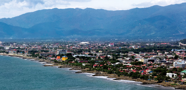
The city of Padang, on the west coast of Sumatra, could be severely impacted if a large earthquake occurs in the Mentawai Gap along the Sunda Megathrust. Credit: Crisco 1492, CC BY-SA 4.0.
The most functional GPS network in Indonesia is owned by the Indonesian Institute of Sciences (LIPI), a government research organization, and is jointly operated by LIPI’s Research Center for Geotechnology and the Earth Observatory of Singapore (EOS). This research array consists of nearly five dozen satellite-linked GPS stations on Sumatra and on outlying islands, says EOS technical director Paramesh Banerjee. The array measures “movements of all the islands linked to the [Sunda Megathrust]” and other major faults, like the Sumatran Fault, Banerjee says. “GPS provides what is happening before an earthquake occurs — how the surface is deforming, and how the slip is occurring [on a fault] — and what happens after a quake.”
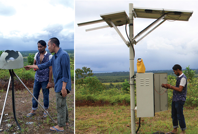
Left: Iwan Hermawan (foreground) of the Earth Observatory of Singapore and his technical assistant Hafiz inspect a GPS station located near Padang, Sumatra. The outer casing of the station is broken, although the GPS unit itself is still operational. Right: Hafiz tests the electronics for the GPS station to make sure it's working properly. Credit: both: Wibi Pangestu Pratama.
The system could, in theory, be modified to work as part of a national earthquake and tsunami warning network, Banerjee suggests. “The best thing is to have one integrated warning system in the Indian Ocean … one that is as close as possible to earthquake sources.” As president of the Asian Seismological Commission, Banerjee is organizing a conference in China to try to create that network out of the patchwork of systems that exist today. Indonesia has announced it will participate.
The Sunda Megathrust remains the most hazardous fault in the Indonesian archipelago. Many seismologists expect that the region’s next great earthquake and tsunami will likely happen in the Mentawai Gap, a portion of the megathrust about 90 kilometers west of central Sumatra. The gap hasn’t seen a significant quake in more than 200 years.
A third-story deck atop this fortified shelter in downtown Padang can accommodate residents fleeing from tsunami floodwaters. The open design is intended to allow water to flow through. Credit: Wibi Pangestu Pratama.
“Mentawai is locked and loading with [seismic] energy, and there has to be an event that will release that stored energy,” says Iwan Hermawan, a geodesist and research fellow at EOS who monitors Sumatra. Along the megathrust at Mentawai, the Eurasian Plate to the east has been shortening and bowing downward as the Indo-Australian Plate slides under it. At some point, the accumulated stress will be too great and a large earthquake — and, most likely, a tsunami — will occur.
The city most vulnerable to a potential quake in the Mentawai Gap and a resultant tsunami is Padang, the largest city on the western coast of Sumatra with a population of more than 800,000. “The risk is high,” Hermawan says, adding that he and EOS director Kerry Sieh believe the Mentawai Gap rupture could happen within the next few decades, or possibly sooner.
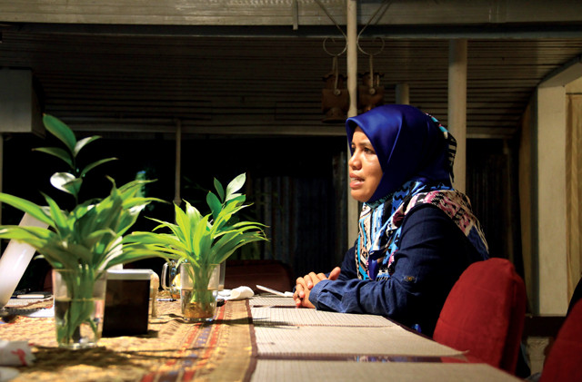
Patra Rina Dewi discusses tsunami education efforts in Padang. Credit: Wibi Pangestu Pratama.
“Much of the loss stemming from the great Aceh-Andaman earthquake and tsunami of 2004 could have been avoided,” Sieh wrote in a 2007 Journal of Earthquake and Tsunami paper. “Similar future losses from earthquakes and tsunamis in South and Southeast Asia could, in theory, be substantially reduced.” Sieh wrote that Indonesia can improve its survival rates in a future disaster by focusing now on scientific discovery, public education about hazards, emergency preparedness, and the design and construction of resilient coastal communities.
But whether Indonesia is adequately prepared today — technologically and in terms of public awareness and preparedness — remains an open question. Some local community organizers have been vigilant about educating the populace and persuading local government officials to act on evacuation plans, but infrastructure and budgets to support such efforts are spotty.
Patra Rina Dewi, a scientist and tsunami educator with a nongovernmental organization called Kogami, has been conducting hazard preparedness training for children and adults in Padang, and urging local and district governments to adopt evacuation and shelter plans. “After 2004, we struggled to get a program of training going for the first two years, and at one point in 2005, the Padang government asked us to stop because they thought we were frightening the tourists,” she says. “But in September 2007, we had a magnitude-7-plus earthquake, and the government woke up and started trusting our organization.”
By 2008, Padang had a tsunami evacuation plan and the city had built tsunami shelters resembling multilevel parking lots that can hold almost 5,000 people. But Dewi still worries that hundreds of thousands of people won’t escape low-lying areas in time if a tsunami comes quickly and washes out key bridges and other infrastructure.
“We’ve done the training,” Dewi says. “We now tell our people that if the earthquake happens [and is] bigger than magnitude 7 … the authorities will make an announcement about a tsunami potential. If you feel a strong earthquake lasting 30 seconds or more and you can’t stand properly, you must evacuate — but don’t take your vehicles; just walk. Get quickly to higher ground — walk at least 3 kilometers away from the beach.”
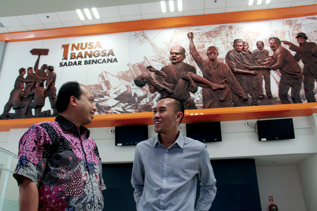
Sutopo Nugroho (left), information director of BNPB, talks with Iwan Hermawan inside the BNPB museum, which is dedicated to natural disaster rescue efforts and the preservation of key artifacts. The sign above reads "Homeland Nation: Aware of Disaster." Credit: Wibi Pangestu Pratama.
Dewi tells people in Padang that the best way to avoid disaster is to recognize the signs for themselves — and as quickly as possible — because improved monitoring technology and communication won’t necessarily help if a massive earthquake happens along a megathrust and forms a tsunami close to the Indonesian islands. She shares her experiences as a rescue worker on Simeulue Island, about 150 kilometers west of Sumatra, after the 2004 earthquake and tsunami struck. Unlike Aceh Province on Sumatra, where nearly 170,000 perished, only 7 people on Simeulue — out of 70,000 residents — drowned during the catastrophe, Dewi says, because locals recalled the stories of their ancestors who faced a tsunami in 1907. When the islanders saw the ocean receding, just before the giant tsunami waves came crashing in, they knew to run for higher ground.
“The children I saw afterward weren’t traumatized; they knew what to do and they seemed happy, even though they saw their houses disappear,” Dewi recalls. “After I returned to Padang, volunteers showed me a magazine saying Padang is the riskiest city in the world for tsunami,” she says. That’s when she discovered her calling. “I know something big will happen in the future if I don’t contribute myself to save people.”
And that’s why rescue workers and organizers like Dewi and Nugroho believe that “local wisdom” is even more effective than GPS, seismometers or other technologies in warning Indonesians of coming disaster. “‘Local wisdom' means people-to-people communication because, basically, disaster mitigation is from people to people,” Nugroho says. “We are trying to develop and integrate local wisdom with technology, so that communities can build the capacity to cope with the disaster themselves,” he says. “We call this the ‘working together spirit.' This means the disaster belongs to us. It’s our responsibility to deal with it.”
© 2008-2021. All rights reserved. Any copying, redistribution or retransmission of any of the contents of this service without the expressed written permission of the American Geosciences Institute is expressly prohibited. Click here for all copyright requests.