
by Mary Caperton Morton Tuesday, February 6, 2018
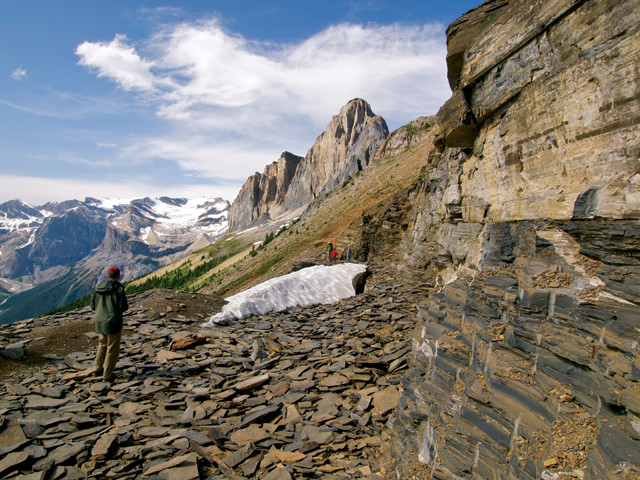
Talus from the fossil-rich Burgess Shale covers the ground in the Walcott Quarry near Field, British Columbia. Credit: Mary Caperton Morton.
Canada’s Burgess Shale is famous for a wide array of exquisitely preserved 500-million-year-old fossils, which are found in a dozen localities in the Canadian Rockies. Linking all these localities today is a geologic feature called the Cathedral Escarpment, which formed in the Cambrian as a steep line of underwater cliffs where regular mudslides are thought to have gently buried a diversity of organisms, setting the stage for the prolific fossil beds. However, new mineralogical clues found at several of the fossil-rich sites suggest that mud volcanism may have also played a starring role in creating the Burgess Shale.
“The Burgess Shale is not a single locality, but rather a stratigraphic unit that extends across many mountains,” says Paul Johnston, a paleontologist at Mount Royal University in Calgary, who presented new research about the Burgess last October at the annual meeting of the Geological Society of America (GSA) in Seattle. “You can find the Burgess Shale rocks exposed in other locations, but not all [sites] contain fossils. Questions we’d like to answer are: Why are the areas of preservation so patchy? And what do the fossil-bearing localities have in common?”
Over the past 10 years, Johnston and co-researcher Stan Keith, of MagmaChem Exploration, based in Sonoita, Ariz., have compared the geochemistry and mineralogy of the rocks found at several Burgess Shale localities in southeastern British Columbia. Starting in the original Walcott Quarry near Field, B.C., and moving southeast along the Kicking Horse Rim to quarries at Mummy Lake and Monarch Mountain, they found the fossil-bearing rocks to be unusually rich in magnesium, containing as much as 30 percent magnesium oxide by weight. “This is a major magnesium anomaly,” Johnston says. “The average marine shale is only about 2.2 percent [magnesium oxide]. So where is it all coming from?”
Since 2009, Johnston and Keith have published several papers detailing how the magnesium could have come from magnesium-rich brines that leaked out along faults on the Cambrian seafloor. In his GSA presentation last fall, Johnston introduced a new idea: The magnesium and faulting may have been linked to hydrothermal venting and mud volcanism on the Cambrian seafloor. One of the most telling clues, Johnston says, is the presence of the mineral serpentine, which the team detected this summer using X-ray diffraction on samples collected in previous years of fieldwork. Serpentine is usually found in low-temperature metamorphic zones and is often associated with mudflows issued from serpentine mud volcanoes.
“Right now, we can’t think of another way to deliver these materials to the Cambrian seafloor other than by deep-sourced mud volcanism,” Johnston says. “What we had originally interpreted as cold brine seeps, we now think are part of a larger set of phenomena that includes mud volcanism and active faulting in that area during the Cambrian.” Mud volcanism may have played a role in periodically burying organisms amid layers of mud, he says, initiating the fossilization process. It may also account for the striking diversity and numbers of organisms in the Burgess: Modern submarine volcanoes and associated seeps are rich in minerals, bacteria and other food resources, and often support a wide array of life.
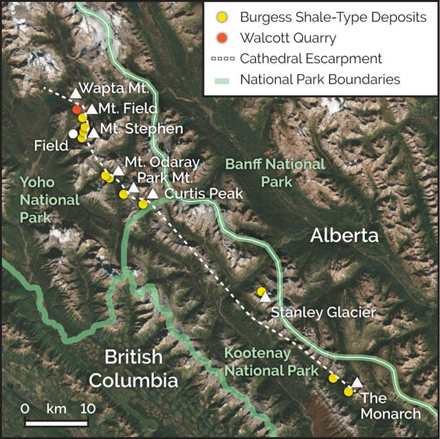
Burgess Shale fossils are found at a dozen localities along the Cathedral Escarpment in the Canadian Rockies. Credit: K. Cantner, AGI.
But not everybody is convinced about the mud volcano hypothesis, or that the magnesium-rich fluids or faulting date back to the same time as the Burgess Shale organisms. “The prevailing view is that the hydrothermal mineralization in the Burgess Shale is clearly post-Cambrian,” says Robert Gaines, a geologist at Pomona College in California who was not involved in the new research. “The movement of fluids along faults wasn’t happening during the Cambrian, but came much later,” he says. Furthermore, “some of these [hydrothermal mineral] deposits have been dated using paleomagnetism to the Cretaceous, when the Rocky Mountains were uplifting.”
Gaines says the next step for Johnston’s team should be to date deposits of sphalerite and other hydrothermal minerals surrounding the faults. “If they are able to show that the mineral deposits from hydrothermal fluids are 500 million years old, that would be conclusive proof to overturn the paradigm that the expected age [of the faults and fluids] is about 100 million years.”
Johnston and Keith plan to publish their recent results in a peer-reviewed journal early this year. “We don’t yet know if mud volcanism is a general model for the various Burgess Shale-type localities,” Johnston says. “This research may provide some impetus for researchers working at other Burgess Shale localities to look more closely for clues. Mud volcanoes are very common in marine settings today, and they may have been during the Cambrian as well.”
© 2008-2021. All rights reserved. Any copying, redistribution or retransmission of any of the contents of this service without the expressed written permission of the American Geosciences Institute is expressly prohibited. Click here for all copyright requests.