
by Russell Blessing and Antonia Sebastian Friday, August 3, 2018
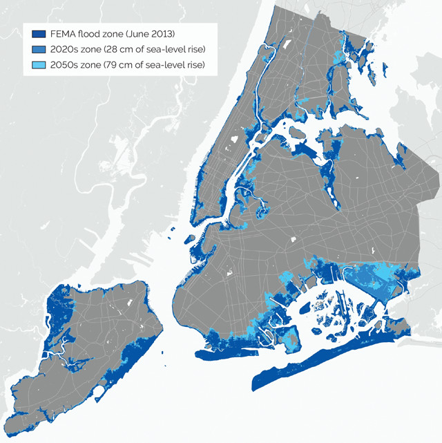
FEMA-projected flooding in New York City during a 100-year flood event. Dark blue is based on 2013 sea level, and lighter shades are expected flood areas for 2020 and 2050 sea levels respectively. Credit: Climate.gov.
In 1968, the United States' National Flood Insurance Program (NFIP) designated the 100-year floodplain — the area of land projected to be covered by water during a flood event that has a one percent chance of occurring in any given year — as the primary mechanism for determining flood insurance premiums. Since then, it has not only become the de facto boundary used to convey flood risk, but it is also the key instrument used to inform household protective actions, development decisions and local flood mitigation policy. However, increasing evidence has illustrated that the 100-year floodplain is a poor predictor of actual flood losses, even for events smaller than a 100-year flood. Nationwide, about a quarter of all insured flood damage occurred outside the FEMA-delineated floodplain. This percentage is even larger in coastal communities where floodplains are more sensitive to changes in the landscape and climate. For example, in Harris County, Texas (where Houston is located), nearly half of all insured flood loss has occurred outside the floodplain. This “out of bounds” flooding, in part, helps explain the NFIP’s current debt of more than $20 billion.
Recently, federal legislators have tried to compensate for this shortfall by increasing premiums and eliminating subsidies. However, this merely shifts the financial burden of flooding further onto homeowners, and skirts underlying issues, particularly inaccurate flood risk delineation. Addressing this issue requires an understanding of the sources of error, such as changing environmental conditions, a lack of long-term and high-resolution data, and problems with the models and methods used to assess flood risk. The last of these is perhaps the most critical.
Flood models often do not accurately capture how stormwater moves through the environment, which ultimately leads to inaccurate flood depth estimates. Additionally, current floodplain maps — which are often more than 15 years old — do not always account adequately for recent and rapid changes in land use, such as the spread of impervious surfaces and the loss of natural habitat, which can significantly increase the depth and extent of a 100-year floodplain. Infrequently updated maps undermine the ability of our flood risk assessments to keep pace with changing environmental conditions such as sea-level rise, subsidence, and changes in land use and land cover. These sources of error are all magnified in the areas most vulnerable to floods: low-lying, rapidly developing coastal watersheds.
The primary consequences of inaccurate floodplain delineation are twofold: delayed or inadequate flood risk adaptation and increasing debt burdens for the NFIP. Inaccurate floodplain delineation undermines the effectiveness of NFIP land-use controls and building codes intended to prevent loss of life and property and guide development away from the floodplain. For example, new construction within the 100-year floodplain must be elevated at or above the anticipated height of the floodwater during a 100-year event. But in areas where the flood hazard is inaccurately delineated, there are homes that should be elevated but which are not, leaving them exposed to damaging flood events. Moreover, these same homeowners are not required to purchase federal flood insurance, and thus are more likely to be uninsured, placing the financial burden on them in the event of a flood. However, if they volunteer to purchase flood insurance, they will pay much less in premiums than those inside the floodplain despite being exposed to nearly the same amount of risk, meaning more of the cost burden of flood damage to their homes is shifted onto the NFIP and ultimately the taxpayer.
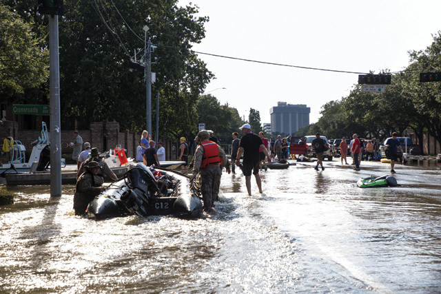
U.S. Marine Corps Reserve servicemen and members of the Texas Highway Patrol and Texas State Guard assist with rescue and relief efforts on a flooded street in Houston on Aug. 31, 2017, following Hurricane Harvey. In Harris County, most of the flood-damaged homes were outside FEMA's designated 100-year, and even 500-year, floodplain. Credit: U.S. Marine Corps photo by Lance Cpl. Niles Lee.
The 2017 hurricane season, directly followed by severe winter storms on the East Coast, pushed the nation’s flood control policies to their breaking point and highlighted the need for a more comprehensive flood risk management program. Several successful initiatives within the NFIP are gaining momentum, including FEMA’s Risk Mapping, Assessment, and Planning (Risk MAP) Program and the Community Rating System (CRS). Risk MAP represents a shift away from traditional flood mapping and toward an integrated process of identifying, assessing, communicating, planning for and mitigating flood-related risks. The CRS is designed to incentivize these behaviors by reducing flood insurance premiums for communities that exceed minimum NFIP standards primarily with nonstructural mitigation activities. For example, the CRS gives extra credit to communities that require homes to be constructed at higher elevations, or that preserve floodplain lands as open space, which has the combined effect of preventing development within flood-prone areas and increasing natural absorption of stormwater.
While these efforts undoubtedly increase flood resilience, it is uncertain how accurately updated flood risk maps will depict the true likelihood of being inundated by flood waters. While the 100-year floodplain may serve as a reasonable indicator of the areas at risk of flooding, it neglects areas where localized ponding occurs outside of the floodplain and fails to account for areas exposed to both storm surge- and rainfall-based flooding at the same time. In a recent study, we found that flooding often occurs well outside the floodplain and that this flooding is not captured using conventional models or methods used to assess flood risk. These flood-prone locations outside of the floodplain typify areas that are chronically flooded by small-scale flood events, leaving them with few opportunities for federal support.
Identifying and communicating about areas outside the regulatory floodplain that experience flood risk must be an integral part of comprehensive flood mitigation. One way to do this would be to allow public access to historical flood damage data so that potential homebuyers are more informed. One such online tool available in Texas, called Buyers Be-Where, allows prospective homebuyers to look up an address and see a graphical representation of flood risk for a specific property. Another option is to improve flood hazard estimates by using state-of-the-art, grid-based hydrologic and inundation models to rapidly account for the influence of small-scale land use and land cover on flooding. Such tools can be used by decision-makers to visualize and communicate the potential for property damage to local residents who may not have flood insurance or be aware of their risk because of their location outside the FEMA floodplain.
In short, people in the U.S. are unable to make informed decisions regarding flood risk management because we have become overly reliant on inaccurate 100-year floodplains. And although the 100-year floodplain will likely continue to serve as an indicator of high-risk areas, it is necessary to continue investing in improving models for flood hazard delineation, risk communication and nonstructural activities that exceed minimum NFIP standards.
© 2008-2021. All rights reserved. Any copying, redistribution or retransmission of any of the contents of this service without the expressed written permission of the American Geosciences Institute is expressly prohibited. Click here for all copyright requests.