
by Lucas Joel Tuesday, May 1, 2018
Mount Pinatubo seen from Clark Air Base on Luzon on June 12, 1991. Credit: U.S. Geological Survey.
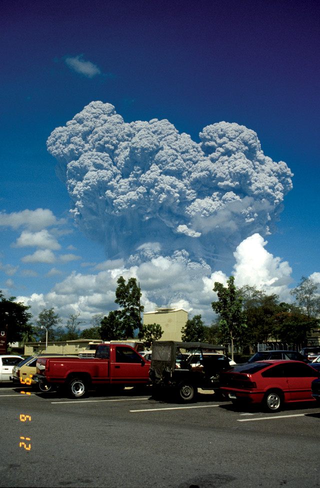
Twenty-seven years ago this month, the calm in central Luzon, the largest and most populous island in the Philippines, turned to chaos. On June 15, 1991, Mount Pinatubo disgorged 5 cubic kilometers of material over a few hours, and ash clouds soared 35 kilometers into the atmosphere. The substantial eruption — the second largest of the 20th century — burned itself into memories and history books.
Before the eruption, 1 million people lived around the volcano, including members of the island’s native Aeta tribe, who called the volcano’s slopes their home. The safety of those living in the area — who needed to know whether, and when, to evacuate — ultimately rested with volcanologists monitoring the volcano. Mount Pinatubo showed signs of unrest months before the eruption, but it was uncertain right up until the very end when it might blow, or even if an eruption would happen at all.
There is no sophisticated monitoring equipment to thank for sensing that something was brewing beneath Pinatubo. Instead, early suspicions came from Catholic nuns living near the volcano.
On July 16, 1990, a magnitude-7.8 earthquake struck about 100 kilometers northeast of Pinatubo. The nuns then saw steam issuing from the ground and felt small earthquakes near the volcano. In August, the nuns and some members of the Aeta tribe traveled to Manila, where they communicated what they had observed to the late volcanologist Ray Punongbayan, who was then director of the Philippine Institute of Volcanology and Seismology (PHIVOLCS). Punongbayan relayed the nuns' tale to Chris Newhall, a volcanologist then with the U.S. Geological Survey (USGS), during a phone call, but Newhall couldn’t be sure that these signs were a buildup to an eruption.
“The typical recurrence period between eruptions at Pinatubo was on the order of a thousand years,” Newhall says, with the last eruption having happened about 500 years earlier. Forecasting when the next eruption would occur was a complete mystery. “There was nothing you could hang your hat on,” he says.
Mount Pinatubo sits on the Pacific Ocean’s Ring of Fire — a string of volcanoes dotting the edge of the Pacific Plate from North America around to East Asia and Oceania. Although it grew quiet again after its July 1990 outburst, more explosions came on April 2, 1991. These were phreatic explosions — mostly steam, with no magma; the steam blasted through surface rock, creating a line of craters on the northeast side of the volcano. Next to the craters, the blasts stripped trees of their branches, and ash dusted tree leaves for a dozen kilometers or more in every direction.
The craters continued to jet steam, and again the nuns and the Aeta traveled to alert Punongbayan. PHIVOLCS installed seismometers on Pinatubo, and the agency began listening to the planet’s stirrings. “They [detected] lots of earthquakes — lots of small earthquakes,” Newhall says. “Immediately that tipped off Punongbayan that something was amiss at Pinatubo.”
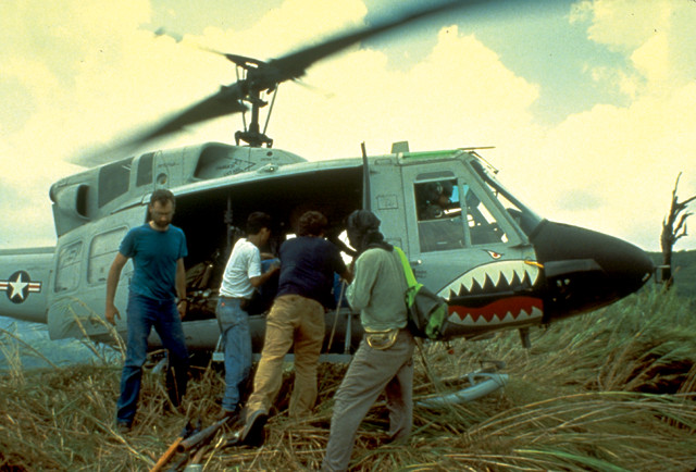
Scientists from the U.S. Geological Survey and the Philippine Institute of Volcanology and Seismology unload volcano monitoring gear from a U.S. Air Force helicopter on the east side of Mount Pinatubo. Credit: U.S. Geological Survey.
" (USAID) in Manila to grant USGS permission to fly a team to the Philippines.
USGS scientists in the Volcano Disaster Assistance Program (VDAP), created in 1986, stand ready to respond to volcanic disasters wherever they may occur around the world. Newhall was part of the VDAP team when Pinatubo was showing signs of unrest, but VDAP deployment is decided upon by USAID, which declined two requests for assistance from Punongbayan.
The USAID director, Newhall explains, did not think there was enough evidence of an impending eruption to justify deploying VDAP. However, clearly something potentially hazardous was happening, so Newhall went around the director. He called a contact at NOAA, who put him in touch with an official at Clark Air Base on Luzon, which at the time was one of the largest U.S. military bases in the world.
Newhall asked the official if the military was aware of the activity at Pinatubo. The official confirmed they were, he says. “And they asked me: ‘When can you be here?'”
Newhall explained to the military the impasse with USAID. The Air Force then called the U.S. Ambassador to the Philippines, who made a call to the USAID director. “I got a telegram from USAID that said: ‘You are to take the next available flight [to the Philippines], and you have $20,000, and do not feel compelled to spend it all.'” Newhall says he didn’t like having to go behind the director’s back to gain authorization. “But, in my judgment, we had to do that,” he says.
After Newhall and his VDAP colleagues landed, they deployed instruments to measure the seismicity, gas emissions and ground swelling around the volcano, but it was still not clear whether or not the volcano would erupt. Seismicity escalated, though, and on June 5, the team issued a warning that an eruption would likely happen within two weeks.
On June 7, the first magma came out of the ground, but the flow was only a trickle and it was not explosive. Then, on June 12, Philippines Independence Day, Pinatubo began releasing its payload. “It looked like an atomic bomb going off,” Newhall says. “That ended all doubt about whether it was going to erupt.”
John Ewert, another volcanologist with USGS, flew to the Philippines on May 23 to support VDAP and the Pinatubo Volcano Observatory (PVO) — a crude monitoring station set up by USGS and PHIVOLCS in empty bedrooms at Clark Air Base. Ewert’s plane flew over Katmai National Park and Preserve, which in 1912 hosted the largest volcanic eruption of the 20th century at Novarupta. He saw from the plane the massive ash flows that came from that eruption. When he got to the Philippines, he saw the ash beds that formed during Pinatubo’s previous eruptions, which blanket the countryside around the volcano, and he recalls thinking they looked “pretty similar” to the Katmai deposits.
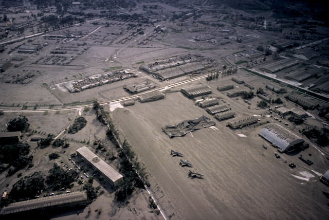
A building (center of image) collapsed under the weight of ash that fell on Clark Air Base from Pinatubo's eruption. Credit: Richard Hoblitt, USGS.
“The Air Force helicoptered PVO scientists to and from Pinatubo, bypassing the rough roads through jungle-covered terrain. “As we got into June … and we got a better sense of how far hazardous flows had traveled from the volcano from past eruptions, we began to be concerned for our own safety.” The eruptions included pyroclastic flows, “incandescently hot avalanches of rock and ash that move very quickly and incinerate and destroy everything in their path,” Ewert says. Clark Air Base sat atop an area flattened by ancient pyroclastic flows. While flatlands make for good landing strips, Ewert says, he knew that flows from a new eruption could easily reach them.
on the morning of June 12, when, just before 9 a.m., the “atomic bomb” went off. Ash soared more than 20 kilometers into the sky, and eventually spread into an umbrella shape.
“Everybody wants to know: Is that the big one? Is that the big one?” Ewert says. It was not the big one. After a few hours of quiet, the seismometers detected more shaking at the volcano. There was an explosion that night, another the next morning, and another in the afternoon on June 14. Seismic activity increased, and on the night of June 14, using military-issue infrared viewing equipment, the team saw incandescent, pyroclastic flows ejecting from the volcano..
0080_1_0.png” caption=“Seismographs at the Pinatubo Volcano Observatory were used to monitor the volcano in the days and weeks leading up to the eruption. Credit: U.S. Geological Survey.” >}}
““The smaller eruptions that occurred a few days before the cataclysmic eruption were the biggest and fastest things I’d ever seen,” recalls Andy Lockhart, a geophysicist with USGS who was part of the VDAP team. “I thought I might die; I thought all my friends there might die; and all the people we were supposed to protect might die.”
By June 14, most of the 14,000 personnel at Clark Air Base had been evacuated, with only the PVO team and core military staff left behind. As dawn broke on June 15, Ewert saw ash filling the entire horizon. But the ash wasn’t the only thing lurking in the atmosphere — Typhoon Yunya hit the Philippines at the same time. The typhoon’s cyclonic winds swept the ash near and far, smothering PVO. “It’s dark, and it’s raining stones and ash, and the wind and the rain — it was impressive,” Ewert says. “We heard roaring sounds,” which came from lahars — slurries of volcanic and other debris mixed with water — flowing down rivers near Clark Air Base. “Nature writes stories that make Hollywood blush,” he says.
Ewert and his team finally evacuated. The main eruption — the one that Pinatubo is famous for — came on the afternoon of June 15. Dubbed a Plinian eruption, Pinatubo released so much material that it collapsed upon itself and formed a caldera.
Between 20,000 and 25,000 people lived close enough to the volcano that if they had remained home, they would’ve been killed in all likelihood, Ewert says. Most residents heeded evacuation warnings, however, and the estimated death toll was far less — about 300 to 400. Most casualties happened as a result of the ash and the typhoon: wet ash piled on roofs, leading to roof collapses as the ground shook during the tumult of the caldera collapse.
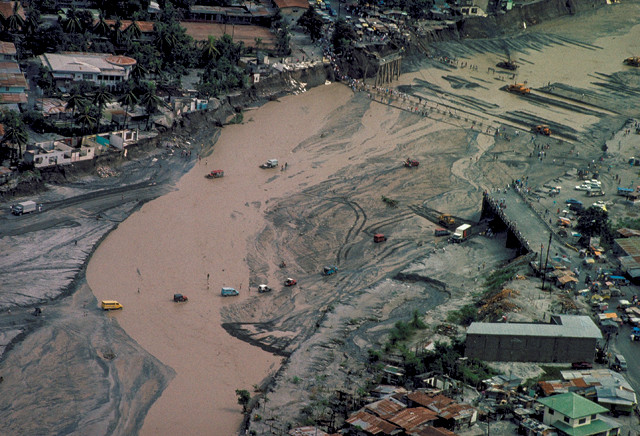
Lahars from the Mount Pinatubo eruption roared down river valleys, destroying homes and bridges and displacing thousands of people. Credit: U.S. Geological Survey.
“After the June 15 eruption, Pinatubo resumed its slumber. Studies of the eruption and its buildup led to new insights about eruptions in general. Ewert points to the earthquakes that predated the eruption and happened far away from the volcano — including the earthquake that hit in July 1990. Magma movement beneath Pinatubo had pressurized the crust around the volcano, and nearby faults failed and slipped. Similar earthquakes have since been spotted around other erupting volcanoes, like Soufrière Hills Volcano on the Caribbean island of Montserrat, and today, volcanologists look for such earthquakes when assessing a volcano’s eruption potential.
Ewert, Newhall and Lockhart note the success of the international collaboration that went into forecasting Pinatubo’s eruption. Pinatubo was the first deployment of VDAP, and working alongside PHIVOLCS — as well as the U.S. military, the Aeta and the nuns — the team managed to help save thousands of lives. “The leaders of the team were frankly heroic — Ray Punongbayan, Chris Newhall, Rick Hoblitt and Dave Harlow. These guys were working under terrible pressure to get it right,” Lockhart says.
The event underscores the difficulty of trying to do scientific work in an environment where there is limited time. “Scientists are routinely taught to be very cautious about what they say,” Newhall says. “In a crisis situation, you don’t have that luxury.” Instead, you need to give others your best guess about what could happen, because there is no room for hesitation. Newhall says he walked away from the experience with a stark realization: “Things that you think are worst-case scenarios can actually happen.”
© 2008-2021. All rights reserved. Any copying, redistribution or retransmission of any of the contents of this service without the expressed written permission of the American Geosciences Institute is expressly prohibited. Click here for all copyright requests.