
by Rachel Crowell Tuesday, March 20, 2018
On June 1, 2009, Air France flight 447 (AF447) from Rio de Janeiro to Paris crashed in the Atlantic Ocean near the mid-ocean ridge, killing all 228 passengers and crew aboard. Credit: BEA, France, bea.aero.
In the early morning hours of March 8, 2014, Malaysia Airlines flight 370 (MH370), en route from Kuala Lumpur to Beijing, lost communication with air traffic control during the transition between Malaysian and Vietnamese air space. It then disappeared, along with all 239 people aboard.
The search for the missing Boeing 777 began the next morning in the South China Sea, its last known location before communication was lost, but no crash site or floating debris was found. The search moved to the vast and turbulent southern Indian Ocean where wisps of satellite and military radar data indicated the flight had ultimately ended. The air and sea search lasted 1,046 days, covered an area of 121,000 square kilometers and cost $157 million before it was jointly called off by the governments of Australia, China and Malaysia in January 2017.
The mysterious case — featuring a series of revelations about the plane’s disabled communications systems, bizarre course changes, and the discovery of debris on an island thousands of kilometers from the hypothesized crash site — is unique in modern aviation.
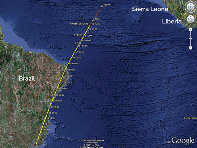
But the search bears some resemblance to the deep-sea search for the elusive wreckage of another lost flight: Air France flight 447 (AF447) from Rio de Janeiro to Paris, which crashed into the Atlantic Ocean 1,145 kilometers off the coast of Brazil on June 1, 2009, killing all 228 passengers and crew aboard.
The search, led by France’s Bureau of Inquiry and Analysis for Civil Aviation Safety (BEA), brought in multiple teams of experts, including aviation safety specialists, engineers, meteorologists, statisticians and oceanographers. On April 4, 2011, after nearly two years of searching, the wreckage of the Airbus A330 was located 3,900 meters below the surface of the Atlantic.
The case of AF447 revealed different ways technology and search efforts can be focused to improve ocean searches and flight safety in the future.
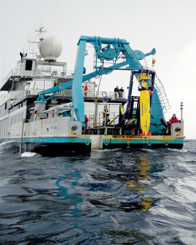
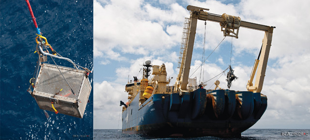
The Remus 6000, an autonomous underwater vehicle (AUV), being held in its launch and recovery system aboard the Alucia during the undersea search for AF447 in the southern Atlantic Ocean. Credit: WHOI.
On Sunday night, May 31, 2009, AF447 took off from Rio de Janeiro’s Galeão International Airport with 216 passengers and 12 crew members, including two co-pilots and one captain. A few hours into the flight to Paris' Charles de Gaulle International Airport, the plane was over the Atlantic about halfway between South America and Africa, where air traffic control is transferred, when it encountered a storm and disappeared from radar.
The first search team lifted off from Dakar, Senegal, nearly 11 hours after the flight’s last communication. BEA and search and rescue authorities organized an international search by aircraft and ships to look for signs of the plane and possible survivors. On the sixth day of the search, the plane’s galley and the first of about 50 bodies ultimately recovered at the surface were found 38 nautical miles from the plane’s last known position.
BEA had estimated that the wreckage would lie within 40 nautical miles based on the plane’s estimated speed and last known position, says Lawrence Stone, chief scientist at Metron, Inc., in Reston, Va., which was commissioned by BEA to narrow the search zone via a statistical analysis, which was later published in Statistical Science. Stone also wrote “Theory of Optimal Search” and was a major technical contributor to the U.S. Coast Guard’s Search and Rescue Optimal Planning System.
Searchers then began an underwater hunt for the remainder of the plane and its flight data and voice recorders, commonly known as black boxes. The search team first used passive acoustic sensors in an attempt to detect the black boxes' underwater locator beacons, or “pingers.” The beacons are designed to emit an acoustic signal as soon as they touch water, but the transmission only lasts 30 to 40 days.
After 31 days, the unsuccessful passive acoustic search was called off and an active acoustic search with sidescan sonar was initiated. BEA commissioned oceanographers to perform a drift analysis based on the locations where bodies and flight debris had already been recovered. The oceanographers delineated a rectangular area north of the plane’s last known position in which they thought the plane was likely to be found and which had not been covered by the passive acoustic search. However, this search, which took place in August 2009, also proved unsuccessful.
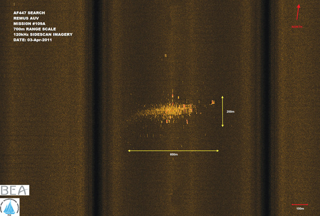
The sidescan sonar image in which the wreckage of AF447 was first identified in April 2011. Credit: WHOI.
While the active towed sonar array search would continue, BEA also sought assistance from the Woods Hole Oceanographic Institution (WHOI) to conduct an undersea search, the first phase of which was completed in April-May 2010.
Over the course of the search, “the number of search days on site for us was probably 50,” says Michael Purcell, WHOI principal engineer who co-led the search with David Gallo, then WHOI director of special projects. Sheer perseverance, along with a sense of camaraderie among searchers, propelled them forward even after the first leg of the undersea search failed to recover the aircraft, he adds. The team also knew what was at stake. “Flying is generally very safe,” but part of how it’s kept that way is by determining the causes of plane crashes and fixing problems as they are identified, Purcell says.
WHOI used three Remus 6000 (Remote Environmental Monitoring Units), autonomous underwater vehicles (AUVs) designed to operate at depths up to 6,000 meters. The miniature submarine-like devices, unattached to any ships by cable, use acoustic navigation, sidescan sonar and high-resolution imaging to conduct surveys of the ocean bottom. At the time of the search, the Remus 6000 was the only AUV that could operate at a depth of 6,000 meters, Purcell says.
Advanced equipment wasn’t the only advantage the WHOI team had. “We brought the experience of looking for things under the ocean … We have a lot of confidence in the equipment and are willing to try things that others … are more reluctant to do,” he says.
Purcell and other WHOI experts are constantly refining their AUV equipment, which can lead to improvements from one operation to the next, he notes. Their AUVs currently have the ability to scan an area spanning 700 meters to either side of the AUV, but he’s hoping researchers will soon be able to pause that wide search — interrupting the AUV’s programmed mission — and instruct it to retrieve more detailed images of a detected anomaly. “If that advance comes to fruition,” he says, “it will save time during future searches.”
In July 2010, BEA tasked Metron with developing a probability map to determine where to continue the search. Stone and his team implemented a Bayesian inference approach, which applies Bayesian statistics to develop a search pattern. This approach has previously been used for undersea searches, for example, to locate the U.S. Navy submarine U.S.S. Scorpion, which sank with 99 submariners aboard southwest of the Azores in 1968.
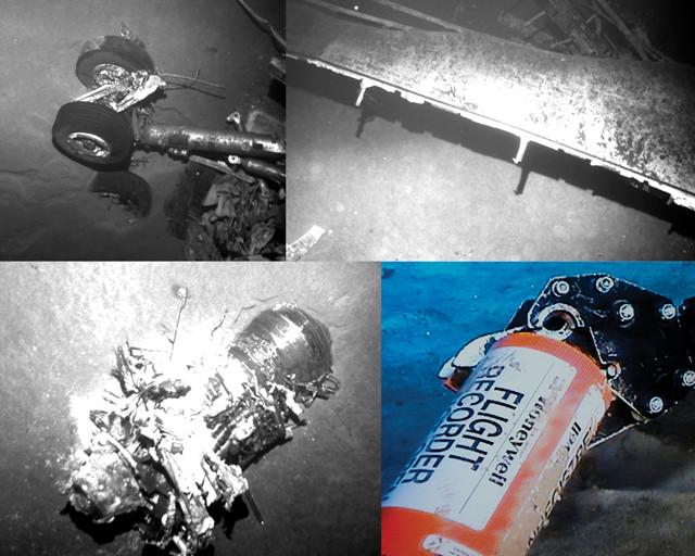
AUVs imaged the wreckage, including (clockwise from top left) part of the landing gear, a wing, a flight recorder and an engine, which aided in identification, analysis and recovery. Credit: all: BEA, France, www.bea.aero.
The earlier drift analysis approach was too narrow, Stone says. Bayesian inference is a better way to incorporate much of the information that’s available during complex searches. He and his collaborators created a probability distribution that incorporated information learned during the search process up to that point, such as the probability that the wreckage was located outside of search areas, uncertainties about ocean currents at the time of the crash, and the likelihood that unknown effects had rendered previous searches ineffective.
According to Stone, team member Johan Strumpfer, a visiting professor of systems research at the University of Cape Town in South Africa, proposed an assumption for their model that proved crucial in determining where the search for AF447 should continue: that the locator beacons had failed.
Based on this assumption, the statistical team recommended performing an active acoustical search in an area that had already been covered by the passive search. “In fact, the 2011 [undersea] search commenced in the center of the [probability] distribution and quickly found the wreckage,” they wrote. In early May 2011, the cockpit voice recorder and flight data recorder were found and recovered.
In July 2012, BEA released its final report on the loss of AF447 based on the recovered wreckage, including information from the flight data and cockpit voice recorders. The investigators concluded that the accident resulted from a succession of events that began with a “temporary inconsistency between the measured air speeds, likely following the obstruction of the Pitot probes [airspeed indicators] by ice crystals that led in particular to autopilot disconnection.” This led to a series of pilot errors that produced a stall from which the pilots could not regain control.
In early May 2011, searchers recovered the flight recorders (left) and other parts of AF447, including an engine and the avionics bay (right) containing the onboard computers. Credit: both: BEA, France, www.bea.aero.
The lessons learned during the search for AF447, and during the subsequent investigation into the details of the crash, most certainly influenced the search for MH370 — which was rekindled in January 2018 with a new undersea search attempt.
The MH370 search also employed a Bayesian statistical approach, detailed in a July 2016 book, to identify the plane’s most likely final location.
However, in December 2016, a new search area was suggested after a drift analysis that considered the July 2015 discovery of a barnacle-encrusted wing flaperon and other debris, including a tattered suitcase that washed up on the French island of Réunion, off the coast of Madagascar in the western Indian Ocean. Based on the predominant circulation pattern of the Indian Ocean, which is a counterclockwise-rotating gyre, and the length of time indicated by the degree of barnacle growth on the wing piece, researchers suggested the crash site could be north of the previously searched areas.
The most important lesson, however, may be that “it took almost two years to locate the wreckage from the Air France accident,” Purcell said in an interview shortly after the loss of MH370. “Determining what happened, deciding where to look, and then looking, can take a long time.”
On Jan. 10, 2018, the Malaysian government and Ocean Infinity, an ocean technology company based in Houston, Texas, struck a “no find, no fee” deal to search for MH370, the New York Times reported. The self-described “seabed intelligence” company could earn as much as $70 million if they find the wreckage or flight data recorders within 90 days of commencing the search, which began on Jan. 22 with two ships and eight AUVs. The team is focusing on a search field of about 25,000 square kilometers off the coast of Australia.
While some critics say it’s time to abandon the search for MH370, Purcell says there will be two significant losses if the wreckage or data recorders are never found: First, the victims' families won’t have the closure of knowing more about the events leading up to their loved ones' deaths, or the chance to possibly receive their remains. And, second, aviation safety specialists won’t have the opportunity to determine the cause of the crash and take steps that could prevent similar tragedies from happening in the future.
© 2008-2021. All rights reserved. Any copying, redistribution or retransmission of any of the contents of this service without the expressed written permission of the American Geosciences Institute is expressly prohibited. Click here for all copyright requests.